Munro · Central Highlands
Beinn Bheoil
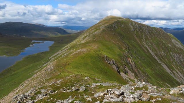
Beinn Bheoil (1019m) — "the hill of the mouth" — is the immediate eastern neighbour of Ben Alder, the great wedge-shaped Munro that dominates the Ben Alder forest. The two are separated by the deep Bealach Breabag and are almost always climbed together as a pair. Beinn Bheoil itself is a long whaleback summit with the iconic view of Ben Alder's east cliffs falling directly to Loch a' Bhealaich Bheithe. The classic approach is via a wild camp or bothy stay at Culra (now ruinous) or Ben Alder Cottage.
Quick facts
- Height
- 1019m/ 3343ft
- Prominence
- 186 m
- Distance
- 17 km
- Ascent
- 897 m
- Time
- 5–8 hrs
- Grid ref
- NN517717
- Parking
- NN637850
- Nearest city
- Fort William· 41km
- Dogs
- Dogs on lead required near livestockDog-friendly guide ↗
Height and prominence cross-checked against the Database of British and Irish Hills (CC BY).
No GPX track yet
Walked this route? Share your track to help other walkers.
Standard route
Loch Ericht track 40% · Open hillside 35% · Summit 25%
From Dalwhinnie head south on bike or foot along the private estate road that runs the length of Loch Ericht to Ben Alder Cottage on the shore of the loch, or to the ruinous Culra bothy north-west of the hills. From Ben Alder Cottage climb the steep north-west ridge directly to Beinn Bheoil, then traverse north over Sron Coire na h-Iolaire and continue to Ben Alder via the Bealach Breabag. Around 30km with 1500m of ascent including the bike-in — usually done over two days with a wild camp.
Terrain
The Dalwhinnie estate landrover track is excellent for fast bike access — one of the longer Highland approach tracks. The climb from Loch Ericht onto Beinn Bheoil is rough heathery hillside with no clear path until higher up. The summit ridge is broad mossy turf. The Bealach Breabag connection to Ben Alder involves a steep drop and steep climb on grass and broken rock. Both Culra and Ben Alder Cottage are reduced in serviceability — verify before relying on them.
In winter
A serious remote winter undertaking with significant commitment. The Dalwhinnie estate track is often drifted closed for weeks at a time in winter. Once committed there is no easy retreat. The Ben Alder east cliffs hold continuous winter climbing routes and the Bealach Breabag accumulates deep avalanche-prone snow. Phone signal absent throughout. SAIS Creag Meagaidh applies to the north side; the south is unrated.
This hill is in the Creag Meagaidh SAIS forecast area. Check SAIS forecasts in winter (December–April).
Best time of year
Getting there
- Glasgow2h 16m
- Edinburgh3h 36m
OS maps: OS Landranger 42
Mobile signal: No signal in the Ben Alder area. Dalwhinnie has 4G. No coverage on the approach or summit. Get mapping saved before a long drive.
Current conditions
Daylight Today
- Sunrise
- 05:00
- Sunset
- 21:48
- Civil dawn
- 04:05
- Civil dusk
- 22:43
NOAA Solar Calculator · 23 July 2026
Pair with
Curated multi-hill combinations from Beinn Bheoil.
Around Beinn Bheoil on the SCOT network
Getting there, basing yourself, and what to do off the hill.
Getting there: Corrour station
Highest mainline station; Loch Ossian, Ben Alder, Aonach Beag (Alder)
17km from the hill
tripscot.co.uk
On TripSCOTBase yourself in Aberfeldy
Loch Tay base — Ben Lawers, Tarmachan ridge, Birks of Aberfeldy
41km from the hill
tripscot.co.uk
On TasteSCOTAfter the hill: Dalwhinnie
Dalwhinnie — Scotland's highest distillery on the Drumochter pass
18km from the hill
tastescot.co.uk
Beinn Bheoil — common questions
- What difficulty is Beinn Bheoil?
- On the OutdoorSCOT scale, Beinn Bheoil comes in at 4/5 — challenging. Expect roughly 17km and 897m of ascent on the usual route — 5-8 hours for most parties. Ground conditions: The Dalwhinnie estate landrover track is excellent for fast bike access — one of the longer Highland approach tracks.
- How much drop does Beinn Bheoil have?
- The drop is 186m: measured from the summit of Beinn Bheoil down to the saddle joining it to higher terrain.
- Where's the parking for Beinn Bheoil?
- Park at NN637850. Double-check the grid reference on an OS map first; informal laybys here fill early in high season.
- What's the best month to climb Beinn Bheoil?
- Aim for May, June, July, August, September, October on Beinn Bheoil. In the remaining months treat it as a winter hill — full kit, solid navigation, and a look at the relevant SAIS avalanche forecast before you go.
- Can dogs go up Beinn Bheoil?
- Dogs are fine on a lead. The route passes livestock or ground-nesting bird habitat, so keep them close throughout.
- Will I get phone signal on Beinn Bheoil?
- No signal in the Ben Alder area. Dalwhinnie has 4G. No coverage on the approach or summit. Get mapping saved before a long drive.
- Is Beinn Bheoil safe in winter?
- A serious remote winter undertaking with significant commitment. The Dalwhinnie estate track is often drifted closed for weeks at a time in winter. Once committed there is no easy retreat. The Ben Alder east cliffs hold continuous winter climbing routes and the Bealach Breabag accumulates deep avalanche-prone snow. Phone signal absent throughout. SAIS Creag Meagaidh applies to the north side; the south is unrated.
Get the OutdoorSCOT weekly
One email a week — new route, hill and bothy guides, seasonal conditions and the odd hard-won lesson. No spam, unsubscribe in one click.