Munro · Central Highlands
Ben Alder
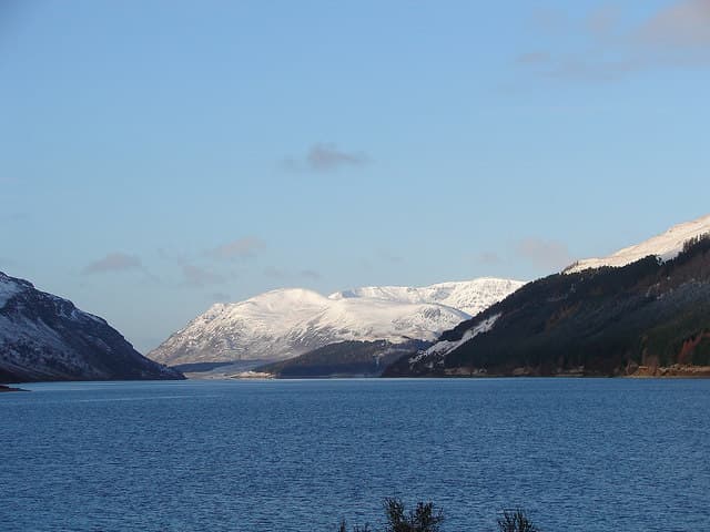
Ben Alder is the 1148m Munro at the heart of the Central Highlands wilderness, sitting in the great empty quarter between Dalwhinnie, Loch Ossian and Loch Rannoch. The summit is a trig point on a wide rocky plateau, ringed on its east side by the dramatic cliffs of Garbh Choire and Coire na Lethchois — among the great corrie systems of the country. The hill has a strong cultural place in Highland history: Bonnie Prince Charlie hid in a cave on the south flank after Culloden, and the Ben Alder estate remains one of the most remote inhabited spots in Britain.
Quick facts
- Height
- 1148m/ 3766ft
- Prominence
- 783 m
- Distance
- 19 km
- Ascent
- 1010 m
- Time
- 6–9 hrs
- Grid ref
- NN496718
- Parking
- NN634849
- Nearest city
- Fort William· 39km
- Dogs
- Dogs on lead required near livestockDog-friendly guide ↗
Height and prominence cross-checked against the Database of British and Irish Hills (CC BY).
No GPX track yet
Walked this route? Share your track to help other walkers.
Standard route
Glen / lochside track 50% · Open hillside 30% · Summit plateau 20%
The traditional approach is from Dalwhinnie via the long bike-and-walk route past Loch Pattack to Culra (now ruined as a bothy but the area remains a popular wild-camp). From Culra climb the Long Leachas ridge or the easier Bealach Dubh approach. Around 36km return — bike strongly recommended for the lower 14km. Many parties spend two days, camping near Culra or using Ben Alder cottage on Loch Ericht. Often combined with Beinn Bheoil.
Terrain
The Dalwhinnie estate road is firm gravel and bike-friendly. The Long Leachas ridge is a Grade 1 scramble on rocky steps — exposed in places but well-graded. The plateau is broad gravel and short heather; the trig pillar sits on a small platform. The east-side corries are unfenced and crag-broken; in mist navigation matters.
In winter
A major winter expedition with full alpine commitment. Ben Alder's east-facing Garbh Choire cliffs hold Grade III-V winter ice and mixed routes. The Long Leachas in winter is a serious Grade I scramble. The plateau navigation in poor visibility has caused several fatal accidents. Phone signal is absent throughout — full self-reliance essential. SAIS Lochaber covers the area indirectly.
This hill is in the Creag Meagaidh SAIS forecast area. Check SAIS forecasts in winter (December–April).
Best time of year
Getting there
- Glasgow2h 16m
- Edinburgh3h 38m
OS maps: OS Landranger 42
Mobile signal: No signal throughout. Ben Alder is one of the very remotest Munros in Scotland — the nearest road is 12km away at Dalwhinnie or via boat on Loch Ericht. Carry a satellite communicator.
Current conditions
Daylight Today
- Sunrise
- 05:00
- Sunset
- 21:48
- Civil dawn
- 04:05
- Civil dusk
- 22:43
NOAA Solar Calculator · 23 July 2026
Pair with
Curated multi-hill combinations from Ben Alder.
Around Ben Alder on the SCOT network
Getting there, basing yourself, and what to do off the hill.
Getting there: Corrour station
Highest mainline station; Loch Ossian, Ben Alder, Aonach Beag (Alder)
15km from the hill
tripscot.co.uk
On TripSCOTBase yourself in Fort William
Ben Nevis base, West Highland Line, gateway to Lochaber
39km from the hill
tripscot.co.uk
On TasteSCOTAfter the hill: Dalwhinnie
Dalwhinnie — Scotland's highest distillery on the Drumochter pass
19km from the hill
tastescot.co.uk
Ben Alder — common questions
- How difficult is Ben Alder?
- Ben Alder carries a 4/5 (challenging) grade on the OutdoorSCOT scale. Count on about 19km, 1010m of ascent and a 6-9 hour day on the standard route. Ground conditions: The Dalwhinnie estate road is firm gravel and bike-friendly.
- How much drop does Ben Alder have?
- The drop is 783m: measured from the summit of Ben Alder down to the saddle joining it to higher terrain.
- Where's the parking for Ben Alder?
- Park at NN634849. Double-check the grid reference on an OS map first; informal laybys here fill early in high season.
- What's the best month to climb Ben Alder?
- Aim for May, June, July, August, September, October on Ben Alder. In the remaining months treat it as a winter hill — full kit, solid navigation, and a look at the relevant SAIS avalanche forecast before you go.
- Can dogs go up Ben Alder?
- Dogs are fine on a lead. The route passes livestock or ground-nesting bird habitat, so keep them close throughout.
- Will I get phone signal on Ben Alder?
- No signal throughout. Ben Alder is one of the very remotest Munros in Scotland — the nearest road is 12km away at Dalwhinnie or via boat on Loch Ericht. Carry a satellite communicator.
- Is Ben Alder safe in winter?
- A major winter expedition with full alpine commitment. Ben Alder's east-facing Garbh Choire cliffs hold Grade III-V winter ice and mixed routes. The Long Leachas in winter is a serious Grade I scramble. The plateau navigation in poor visibility has caused several fatal accidents. Phone signal is absent throughout — full self-reliance essential. SAIS Lochaber covers the area indirectly.
Get the OutdoorSCOT weekly
One email a week — new route, hill and bothy guides, seasonal conditions and the odd hard-won lesson. No spam, unsubscribe in one click.