Munro · Central Highlands
Aonach Beag
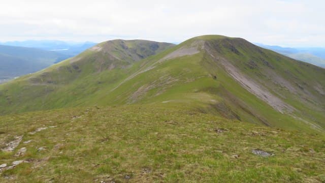
This Aonach Beag — not to be confused with the better-known Aonach Beag east of Ben Nevis — is the 1116m Munro in the Ben Alder forest, one of the four "Pattack Munros" alongside Geal-charn, Beinn Eibhinn and Carn Dearg. The summit is a small cairn on a rocky platform along the broad Ben Alder plateau, looking out over Loch Pattack and across to the bigger Ben Alder massif. Almost always tackled as part of a multi-Munro round from Culra.
Gaelic: “high ridge, small” · Pronunciation: oeun-ach bek
Quick facts
- Height
- 1115.8m/ 3661ft
- Prominence
- 99 m
- Distance
- 18 km
- Ascent
- 982 m
- Time
- 6–9 hrs
- Grid ref
- NN457741
- Parking
- NN634849
- Nearest city
- Fort William· 35km
- Dogs
- Dogs on lead required near livestockDog-friendly guide ↗
Height and prominence cross-checked against the Database of British and Irish Hills (CC BY).
No GPX track yet
Walked this route? Share your track to help other walkers.
Standard route
Long approach track 40% · Open hillside 35% · Summit plateau 25%
The Pattack four-Munro round is the classic line: cycle from Dalwhinnie to Culra (14km), then climb the Lancet Edge or Beinn Eibhinn ridge to gain the broad summit plateau and traverse Aonach Beag, Beinn Eibhinn, Geal-charn and Carn Dearg in a circular route. Around 30km on foot from Culra with 1500m of ascent. The 18km/982m figures relate to Aonach Beag alone from a Culra base.
Terrain
The estate track from Dalwhinnie to Loch Pattack is well-graded gravel — best ridden in. The Lancet Edge route is a Grade 1 scramble; the easier alternative gains the plateau via the south ridge of Beinn Eibhinn. The plateau itself is granite gravel and short grass, broad and exposed. The summit cairn sits on a small rocky platform. No exposure on the standard plateau route.
In winter
A major remote winter expedition. The Lancet Edge under snow becomes a Grade I-II mixed climb. The Pattack plateau picks up sustained snow cover and drifts deep against the broad slopes. Phone signal is absent throughout; Culra is now ruined and no longer reliable shelter. SAIS Lochaber gives a regional indicator. Full self-sufficiency essential.
This hill is in the Creag Meagaidh SAIS forecast area. Check SAIS forecasts in winter (December–April).
Best time of year
Getting there
- Glasgow2h 20m
- Edinburgh3h 43m
OS maps: OS Landranger 42
Mobile signal: No reception above 700m in the Ben Alder area. Dalwhinnie or Newtonmore has 4G. Save maps before the long drive to the start.
Current conditions
Daylight Today
- Sunrise
- 05:00
- Sunset
- 21:49
- Civil dawn
- 04:05
- Civil dusk
- 22:44
NOAA Solar Calculator · 23 July 2026
Pair with
Curated multi-hill combinations from Aonach Beag.
Around Aonach Beag on the SCOT network
Getting there, basing yourself, and what to do off the hill.
Getting there: Tulloch station
Loch Treig; Beinn na Lap; Stob Coire Easain / Stob a Choire Mheadhoin approach
12km from the hill
tripscot.co.uk
On TripSCOTBase yourself in Fort William
Ben Nevis base, West Highland Line, gateway to Lochaber
35km from the hill
tripscot.co.uk
On TasteSCOTAfter the hill: Dalwhinnie
Dalwhinnie — Scotland's highest distillery on the Drumochter pass
21km from the hill
tastescot.co.uk
Aonach Beag — common questions
- Is Aonach Beag a hard climb?
- Aonach Beag is rated 4/5 (challenging) on the OutdoorSCOT scale. The standard route covers about 18km with 982m of ascent and takes most walkers 6-9 hours. Terrain: The estate track from Dalwhinnie to Loch Pattack is well-graded gravel — best ridden in.
- How prominent is Aonach Beag?
- Aonach Beag has 99m of topographic prominence — the height of its summit above the highest col connecting it to higher ground.
- Where should I park to climb Aonach Beag?
- Standard parking is at NN634849. Check the parking grid reference on an OS map before travel; informal laybys can fill on summer weekends.
- When should I climb Aonach Beag?
- The standard good-weather months for Aonach Beag are May, June, July, August, September, October. Outside those months, expect winter conditions on the high ground — full mountain kit, navigation skills, and a check of the SAIS avalanche forecast for the relevant region.
- Can I bring my dog up Aonach Beag?
- On a lead only — the route crosses ground with livestock or nesting-bird interest.
- What's mobile reception like on Aonach Beag?
- No reception above 700m in the Ben Alder area. Dalwhinnie or Newtonmore has 4G. Save maps before the long drive to the start.
- Is Aonach Beag safe in winter?
- A major remote winter expedition. The Lancet Edge under snow becomes a Grade I-II mixed climb. The Pattack plateau picks up sustained snow cover and drifts deep against the broad slopes. Phone signal is absent throughout; Culra is now ruined and no longer reliable shelter. SAIS Lochaber gives a regional indicator. Full self-sufficiency essential.
Get the OutdoorSCOT weekly
One email a week — new route, hill and bothy guides, seasonal conditions and the odd hard-won lesson. No spam, unsubscribe in one click.