Corbett · Central Highlands
Beinn Pharlagain - Meall na Meoig (Meall na Meoig)
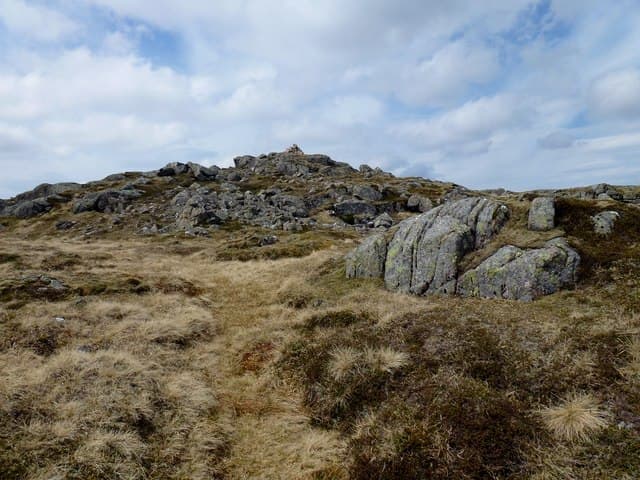
Meall na Meoig is the high point of Beinn Pharlagain, an extensive ridge of low rounded tops on the south-west side of Loch Ericht, deep in the empty country between Rannoch Moor and Ben Alder. At 867m it is dwarfed by the Munro Sgor Gaibhre across the bealach to its north, and most baggers tag it on at the end of a Sgor Gaibhre / Carn Dearg round rather than visit it alone. The summit is a slab of rock with an unbroken view across the wastes of Rannoch.
Quick facts
- Height
- 867.3m/ 2845ft
- Prominence
- 192 m
- Distance
- 16 km
- Ascent
- 763 m
- Time
- 5–8 hrs
- Grid ref
- NN448642
- Parking
- NN423578
- Nearest city
- Fort William· 35km
- Dogs
- Dogs on lead required near livestockDog-friendly guide ↗
Height and prominence cross-checked against the Database of British and Irish Hills (CC BY).
No GPX track yet
Walked this route? Share your track to help other walkers.
Standard route
forest path 20% · blanket bog 45% · broad ridge 25% · summit slab 10%
Start from Rannoch Station, reached by the single-track road in from Kinloch Rannoch, and take the stalkers path north-east through the trees and onto Loch Eigheach moor. After 3–4km, leave the path to climb east onto the broad south ridge of Meall na Meoig and continue pathless to the cairn. Day works out at roughly 16km out-and-back and 763m up. Most parties extend over Sgor Gaibhre and Carn Dearg for a full Ben Alder forest day.
Terrain
The Loch Eigheach path is firm in patches but degrades to wet peat and small burns crossings. Off the path the ground is classic Rannoch — blanket bog, peat hag and tussocky grass — slow underfoot in any season. The summit ridge is gentler, with short heather and small rock outcrops. The slab cairn at the top is easy to miss in poor visibility on the featureless dome.
In winter
A serious winter Corbett mostly because of the long approach across exposed moor — drifting snow can render the path invisible and the featureless plateau is a navigation trap in whiteout. No significant avalanche slopes but cornicing can form on the east edge above Loch Ericht. Rannoch Station is reliably accessible by the West Highland Line; the road in often closes in heavy snow.
This hill is in the Creag Meagaidh SAIS forecast area. Check SAIS forecasts in winter (December–April).
Best time of year
Getting there
- Glasgow2h 7m
- Edinburgh3h 35m
OS maps: OS Landranger 42
Mobile signal: No signal on the moor; Rannoch Station has limited reception
Current conditions
Daylight Today
- Sunrise
- 04:51
- Sunset
- 21:58
- Civil dawn
- 03:53
- Civil dusk
- 22:56
NOAA Solar Calculator · 17 July 2026
Pair with
Curated multi-hill combinations from Beinn Pharlagain - Meall na Meoig (Meall na Meoig).
Got a photo of Beinn Pharlagain - Meall na Meoig (Meall na Meoig)?
30 seconds, helps other walkers.
Submit a photoAround Beinn Pharlagain - Meall na Meoig (Meall na Meoig) on the SCOT network
Getting there, basing yourself, and what to do off the hill.
Getting there: Rannoch station
Rannoch Moor — remote West Highland Line stop; Schiehallion approach via bus
7km from the hill
tripscot.co.uk
On TripSCOTBase yourself in Fort William
Ben Nevis base, West Highland Line, gateway to Lochaber
35km from the hill
tripscot.co.uk
On TasteSCOTAfter the hill: Dalwhinnie
Dalwhinnie — Scotland's highest distillery on the Drumochter pass
28km from the hill
tastescot.co.uk
Beinn Pharlagain - Meall na Meoig (Meall na Meoig) — common questions
- How difficult is Beinn Pharlagain - Meall na Meoig (Meall na Meoig)?
- Beinn Pharlagain - Meall na Meoig (Meall na Meoig) carries a 4/5 (challenging) grade on the OutdoorSCOT scale. Count on about 16km, 763m of ascent and a 5-8 hour day on the standard route. Underfoot: The Loch Eigheach path is firm in patches but degrades to wet peat and small burns crossings.
- What is Beinn Pharlagain - Meall na Meoig (Meall na Meoig)'s prominence?
- 192m of prominence. That's the vertical drop from the summit to the col that links Beinn Pharlagain - Meall na Meoig (Meall na Meoig) to the next higher ground.
- Where do I park for Beinn Pharlagain - Meall na Meoig (Meall na Meoig)?
- Most walkers start from NN423578. Verify the grid reference on an OS map before you set off — space is tight on busy summer weekends.
- When is the best time to climb Beinn Pharlagain - Meall na Meoig (Meall na Meoig)?
- May, June, July, August, September, October give the most reliable conditions on Beinn Pharlagain - Meall na Meoig (Meall na Meoig). Beyond that window the high ground turns wintry: carry full mountain kit, be confident navigating, and check the SAIS avalanche forecast for the area.
- Is Beinn Pharlagain - Meall na Meoig (Meall na Meoig) dog-friendly?
- Yes, but dogs must be kept on a lead — there is livestock or ground-nesting bird interest on the route.
- Is there mobile signal on Beinn Pharlagain - Meall na Meoig (Meall na Meoig)?
- No signal on the moor; Rannoch Station has limited reception
- Is Beinn Pharlagain - Meall na Meoig (Meall na Meoig) safe in winter?
- A serious winter Corbett mostly because of the long approach across exposed moor — drifting snow can render the path invisible and the featureless plateau is a navigation trap in whiteout. No significant avalanche slopes but cornicing can form on the east edge above Loch Ericht. Rannoch Station is reliably accessible by the West Highland Line; the road in often closes in heavy snow.
Get the OutdoorSCOT weekly
One email a week — new route, hill and bothy guides, seasonal conditions and the odd hard-won lesson. No spam, unsubscribe in one click.