Munro · Central Highlands
Carn Dearg
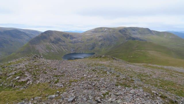
Càrn Dearg (1034m) is the easternmost of the four "Pattack Munros" — the remote group at the head of Loch Pattack in the Ben Alder forest that also includes Beinn Eibhinn, Aonach Beag and Geal-charn. The hill is a long broad shoulder rather than a sharp summit, with a small cairn at the high point and panoramic views east towards Drumochter and west to Ben Alder itself. Access requires a long walk or bike-in from Dalwhinnie.
Gaelic: “cairn-topped hill, red” · Pronunciation: karn jerr-ak
Quick facts
- Height
- 1034.1m/ 3393ft
- Prominence
- 158 m
- Distance
- 17 km
- Ascent
- 910 m
- Time
- 5–8 hrs
- Grid ref
- NN504764
- Parking
- NN637850
- Nearest city
- Fort William· 40km
- Dogs
- Dogs on lead required near livestockDog-friendly guide ↗
Height and prominence cross-checked against the Database of British and Irish Hills (CC BY).
No GPX track yet
Walked this route? Share your track to help other walkers.
Standard route
Estate track / ATV track 50% · Open moorland 35% · Summit 15%
Cycle or walk from Dalwhinnie south-west along the private estate track past Loch Ericht to Ben Alder Lodge, then continue past Loch Pattack to the bothy at Culra (now ruinous — not safe for shelter). From there climb the south ridge of Càrn Dearg, then traverse west along the connecting ridge to Geal-charn, Aonach Beag and Beinn Eibhinn — the classic four-Munro Pattack round. Around 36km with 1500m of ascent on bikes; on foot allow two days with a wild camp.
Terrain
The Dalwhinnie–Ben Alder Lodge estate track is firm landrover surface — ideal for bikes. Beyond Culra the going is rough heathery moor with no clear paths. The south ridge of Càrn Dearg is broad mossy turf and gravel. The summit area is a flat top with the cairn at one end. The connecting ridge west to Geal-charn is a broad easy walk over grassy bealachs. Culra bothy is structurally unsafe — do not enter.
In winter
A serious remote winter undertaking. The Dalwhinnie estate road is often the first thing to drift closed in eastern Highlands snow events. The four-Munro round in winter is one of the longest single-day routes in Scotland; most parties go two days with a wild camp. Phone signal absent throughout the day. SAIS Creag Meagaidh applies to the northern aspects. Full self-sufficiency essential.
This hill is in the Creag Meagaidh SAIS forecast area. Check SAIS forecasts in winter (December–April).
Best time of year
Getting there
- Glasgow2h 22m
- Edinburgh3h 42m
OS maps: OS Landranger 42
Mobile signal: Signal gone above 700m on the Monadhliath. Newtonmore has reasonable 4G. The estate tracks into the hills lose signal within a few kilometres.
Current conditions
Daylight Today
- Sunrise
- 05:00
- Sunset
- 21:49
- Civil dawn
- 04:05
- Civil dusk
- 22:44
NOAA Solar Calculator · 23 July 2026
Pair with
Curated multi-hill combinations from Carn Dearg.
Around Carn Dearg on the SCOT network
Getting there, basing yourself, and what to do off the hill.
Getting there: Dalwhinnie station
Highest mainline station; Drumochter Munros; Ben Alder approach
16km from the hill
tripscot.co.uk
On TripSCOTBase yourself in Fort William
Ben Nevis base, West Highland Line, gateway to Lochaber
40km from the hill
tripscot.co.uk
On TasteSCOTAfter the hill: Dalwhinnie
Dalwhinnie — Scotland's highest distillery on the Drumochter pass
16km from the hill
tastescot.co.uk
Carn Dearg — common questions
- Is Carn Dearg a hard climb?
- Carn Dearg is rated 4/5 (challenging) on the OutdoorSCOT scale. The standard route covers about 17km with 910m of ascent and takes most walkers 5-8 hours. Ground conditions: The Dalwhinnie–Ben Alder Lodge estate track is firm landrover surface — ideal for bikes.
- How much drop does Carn Dearg have?
- The drop is 158m: measured from the summit of Carn Dearg down to the saddle joining it to higher terrain.
- Where's the parking for Carn Dearg?
- Park at NN637850. Double-check the grid reference on an OS map first; informal laybys here fill early in high season.
- What's the best month to climb Carn Dearg?
- Aim for May, June, July, August, September, October on Carn Dearg. In the remaining months treat it as a winter hill — full kit, solid navigation, and a look at the relevant SAIS avalanche forecast before you go.
- Can dogs go up Carn Dearg?
- Dogs are fine on a lead. The route passes livestock or ground-nesting bird habitat, so keep them close throughout.
- Will I get phone signal on Carn Dearg?
- Signal gone above 700m on the Monadhliath. Newtonmore has reasonable 4G. The estate tracks into the hills lose signal within a few kilometres.
- Is Carn Dearg safe in winter?
- A serious remote winter undertaking. The Dalwhinnie estate road is often the first thing to drift closed in eastern Highlands snow events. The four-Munro round in winter is one of the longest single-day routes in Scotland; most parties go two days with a wild camp. Phone signal absent throughout the day. SAIS Creag Meagaidh applies to the northern aspects. Full self-sufficiency essential.
Get the OutdoorSCOT weekly
One email a week — new route, hill and bothy guides, seasonal conditions and the odd hard-won lesson. No spam, unsubscribe in one click.