Corbett · Central Highlands
The Sow of Atholl (Meall an Dobharchain)
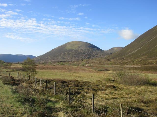
The Sow of Atholl is the shapely conical Corbett on the west side of the Drumochter Pass — visible to every driver heading north on the A9 between Pitlochry and Newtonmore, and amongst the most accessible Corbetts in Scotland for that reason. The English name is a translation of an alternative Gaelic form. The hill makes a short and uncomplicated day from the A9 layby, with the summit giving a vantage point across the Drumochter Munros (A' Bhuidheanach Bheag, the Sow's bigger neighbours) and the long flat-bottomed pass itself.
Quick facts
- Height
- 798.9m/ 2621ft
- Prominence
- 161 m
- Distance
- 9 km
- Ascent
- 530 m
- Time
- 2–4 hrs
- Grid ref
- NN625741
- Parking
- NN632754
- Nearest
- Fort William· Inverness 71km
- Dogs
- Dogs on lead required near livestockDog-friendly guide ↗
Height and prominence cross-checked against the Database of British and Irish Hills (CC BY).
No GPX track yet
Walked this route? Share your track to help other walkers.
Standard route
moorland path 30% · heather moorland 40% · grassy slope 20% · summit area 10%
Park at the large layby on the A9 at NN632754, just south of the Drumochter summit and the entrance to the Balsporran cottages access track. Cross the railway via the underpass and follow the Land Rover track south-west along the Allt Beul an Sporain. After around 2km, leave the track and climb steeply west onto the eastern slopes of the Sow. The route reaches the summit cairn after a steady pull. Descent reverses the line. Allow 3.5–4 hours.
Terrain
Track for the first part — easy. Above the track, grass and heather to the summit. The east side of the Sow holds peat hags in places; pick lines round them. The summit is a small grassy cap with a cairn. Drier than most central Highland hills thanks to the Drumochter rain shadow.
In winter
A great winter introduction Corbett — short, friendly gradients, well-defined terrain, and you can see the whole route from the road. Snow holds reliably on the east aspect. Cold easterlies from the Cairngorms can be brutal on the summit; bring a windproof. The A9 is generally well-cleared but the Drumochter Pass closes occasionally in heavy storms.
This hill is in the Creag Meagaidh SAIS forecast area. Check SAIS forecasts in winter (December–April).
Best time of year
Getting there
- Glasgow2h 19m
- Edinburgh3h 31m
OS maps: OS Landranger 42
Mobile signal: Reasonable EE/Vodafone at the A9 layby; patchy in Coire Beul an Sporain; usable on the summit cone
Current conditions
Daylight Today
- Sunrise
- 04:43
- Sunset
- 22:03
- Civil dawn
- 03:43
- Civil dusk
- 23:03
NOAA Solar Calculator · 13 July 2026
Pair with
Curated multi-hill combinations from The Sow of Atholl (Meall an Dobharchain).
Got a photo of The Sow of Atholl (Meall an Dobharchain)?
30 seconds, helps other walkers.
Submit a photoAround The Sow of Atholl (Meall an Dobharchain) on the SCOT network
Getting there, basing yourself, and what to do off the hill.
Getting there: Dalwhinnie station
Highest mainline station; Drumochter Munros; Ben Alder approach
12km from the hill
tripscot.co.uk
On TripSCOTBase yourself in Aberfeldy
Loch Tay base — Ben Lawers, Tarmachan ridge, Birks of Aberfeldy
34km from the hill
tripscot.co.uk
On TasteSCOTAfter the hill: Dalwhinnie
Dalwhinnie — Scotland's highest distillery on the Drumochter pass
11km from the hill
tastescot.co.uk
The Sow of Atholl (Meall an Dobharchain) — common questions
- What difficulty is The Sow of Atholl (Meall an Dobharchain)?
- On the OutdoorSCOT scale, The Sow of Atholl (Meall an Dobharchain) comes in at 2/5 — moderate. Expect roughly 9km and 530m of ascent on the usual route — 2-4 hours for most parties. Terrain: Track for the first part — easy.
- How prominent is The Sow of Atholl (Meall an Dobharchain)?
- The Sow of Atholl (Meall an Dobharchain) has 161m of topographic prominence — the height of its summit above the highest col connecting it to higher ground.
- Where should I park to climb The Sow of Atholl (Meall an Dobharchain)?
- Standard parking is at NN632754 near Fort William. Check the parking grid reference on an OS map before travel; informal laybys can fill on summer weekends.
- When should I climb The Sow of Atholl (Meall an Dobharchain)?
- The standard good-weather months for The Sow of Atholl (Meall an Dobharchain) are April, May, June, July, August, September, October. Outside those months, expect winter conditions on the high ground — full mountain kit, navigation skills, and a check of the SAIS avalanche forecast for the relevant region.
- Can I bring my dog up The Sow of Atholl (Meall an Dobharchain)?
- On a lead only — the route crosses ground with livestock or nesting-bird interest.
- What's mobile reception like on The Sow of Atholl (Meall an Dobharchain)?
- Reasonable EE/Vodafone at the A9 layby; patchy in Coire Beul an Sporain; usable on the summit cone
- Is The Sow of Atholl (Meall an Dobharchain) safe in winter?
- A great winter introduction Corbett — short, friendly gradients, well-defined terrain, and you can see the whole route from the road. Snow holds reliably on the east aspect. Cold easterlies from the Cairngorms can be brutal on the summit; bring a windproof. The A9 is generally well-cleared but the Drumochter Pass closes occasionally in heavy storms.
Get the OutdoorSCOT weekly
One email a week — new route, hill and bothy guides, seasonal conditions and the odd hard-won lesson. No spam, unsubscribe in one click.