Graham · Central Highlands
Leana Mhor
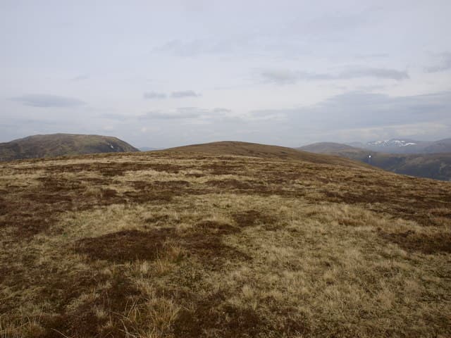
Leana Mhor (683m) — the big meadow — is a broad heathery hill on the north side of Loch Treig, set in the NN28 square between the West Highland Line and the Easains. The name reflects its sweeping cropped-grass summit. From the cairn the view runs south down Loch Treig and west to the Aonachs and Ben Nevis.
Gaelic: “big” · Pronunciation: leana vore
Quick facts
- Height
- 683.9m/ 2244ft
- Prominence
- 174 m
- Distance
- 13 km
- Ascent
- 560 m
- Time
- 4–6 hrs
- Grid ref
- NN284878
- Parking
- NN323872
- Nearest city
- Fort William· 23km
- Dogs
- Dogs on lead required near livestockDog-friendly guide ↗
Height and prominence cross-checked against the Database of British and Irish Hills (CC BY).
No GPX track yet
Walked this route? Share your track to help other walkers.
Standard route
blanket bog 55% · heather moorland 35% · grassy summit 10%
From Tulloch railway station on the West Highland Line follow the track south-west along the Allt Cam to the Lairig Leacach watershed. Strike up the south-east ridge on heather and turf to gain the broad plateau. A small cairn marks the high point at the western end of the meadow.
Terrain
Estate path and forest track for the first 4km, then deep heather and tussock on the south-east ridge. The broad summit plateau is cropped grass and minor peat — easy walking once gained but featureless in cloud. Bog around the headwater burns is unavoidable.
In winter
The Lochaber interior catches heavy Atlantic snow that lies long on this NN28 plateau. Drifting fills the burn channels deceptively and the broad cropped-grass top becomes a whiteout trap. SAIS Creag Meagaidh forecasts cover this ground.
This hill is in the Creag Meagaidh SAIS forecast area. Check SAIS forecasts in winter (December–April).
Best time of year
Getting there
- Glasgow3h 41m
- Edinburgh3h 11m
OS maps: OS Landranger 34, OS Landranger 41
Mobile signal: Weak. Remote Rannoch area; blank on every network.
Current conditions
Daylight Today
- Sunrise
- 04:44
- Sunset
- 22:06
- Civil dawn
- 03:44
- Civil dusk
- 23:07
NOAA Solar Calculator · 13 July 2026
Around Leana Mhor on the SCOT network
Getting there, basing yourself, and what to do off the hill.
Getting there: Roy Bridge station
Glen Roy; Grey Corries (Stob Choire Claurigh, Sgurr Choinnich Mor)
6km from the hill
tripscot.co.uk
On TripSCOTBase yourself in Fort William
Ben Nevis base, West Highland Line, gateway to Lochaber
23km from the hill
tripscot.co.uk
On TasteSCOTAfter the hill: Ben Nevis Distillery
Fort William — Lochaber distillery at the foot of the Ben; long-aged Japanese-owned classics
20km from the hill
tastescot.co.uk
Leana Mhor — common questions
- Is Leana Mhor a hard climb?
- Leana Mhor is rated 4/5 (challenging) on the OutdoorSCOT scale. The standard route covers about 13km with 560m of ascent and takes most walkers 4-6 hours. Ground conditions: Estate path and forest track for the first 4km, then deep heather and tussock on the south-east ridge.
- How much drop does Leana Mhor have?
- The drop is 174m: measured from the summit of Leana Mhor down to the saddle joining it to higher terrain.
- Where's the parking for Leana Mhor?
- Park at NN323872. Double-check the grid reference on an OS map first; informal laybys here fill early in high season.
- What's the best month to climb Leana Mhor?
- Aim for March, April, May, June, July, August, September, October, November on Leana Mhor. In the remaining months treat it as a winter hill — full kit, solid navigation, and a look at the relevant SAIS avalanche forecast before you go.
- Can dogs go up Leana Mhor?
- Dogs are fine on a lead. The route passes livestock or ground-nesting bird habitat, so keep them close throughout.
- Will I get phone signal on Leana Mhor?
- Weak. Remote Rannoch area; blank on every network.
- Is Leana Mhor safe in winter?
- The Lochaber interior catches heavy Atlantic snow that lies long on this NN28 plateau. Drifting fills the burn channels deceptively and the broad cropped-grass top becomes a whiteout trap. SAIS Creag Meagaidh forecasts cover this ground.
Get the OutdoorSCOT weekly
One email a week — new route, hill and bothy guides, seasonal conditions and the odd hard-won lesson. No spam, unsubscribe in one click.