Graham · Glen Coe & Lochaber
Cnap Cruinn
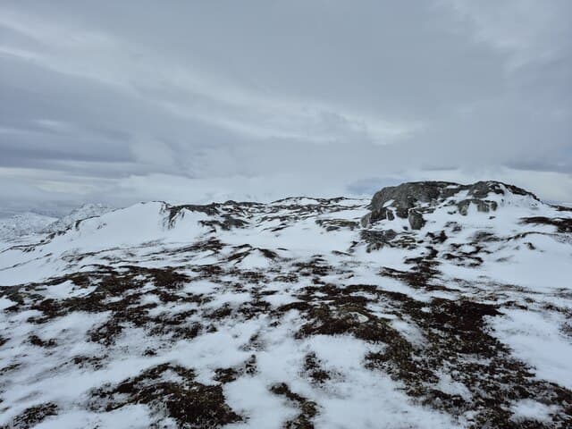
A round knoll between Loch Treig and the upper Spean, looking south to the Easains and west toward the Grey Corries. The summit is a small rock rib at the end of a long heathery rib — pleasingly out of the way.
Quick facts
- Height
- 741.9m/ 2434ft
- Prominence
- 245 m
- Distance
- 14 km
- Ascent
- 608 m
- Time
- 4–7 hrs
- Grid ref
- NN302774
- Parking
- NN349803
- Nearest city
- Fort William· 20km
- Dogs
- Dogs on lead required near livestockDog-friendly guide ↗
Height and prominence cross-checked against the Database of British and Irish Hills (CC BY).
No GPX track yet
Walked this route? Share your track to help other walkers.
Standard route
moorland path 20% · bog and heather 50% · grassy upper slopes 20% · summit area 10%
Take the West Highland Line to Tulloch Station or drive to the carpark there, then walk south-west on the access track past the Easains hostel before striking up the long open north-east ridge to the rib.
Terrain
Estate access track, then trackless tussock and short heather. The summit rib gives a moment of rocky interest in an otherwise grassy day.
In winter
Lochaber SAIS region; the north-east flank holds windslab after westerlies. River crossings down low can become difficult after thaws given the bare ground catchment from the surrounding hills.
This hill is in the Glen Coe SAIS forecast area. Check SAIS forecasts in winter (December–April).
Best time of year
Getting there
- Glasgow2h 28m
- Edinburgh3h 59m
OS maps: OS Landranger 41
Mobile signal: No signal in this remote Rannoch/Etive area
Current conditions
Daylight Today
- Sunrise
- 04:51
- Sunset
- 22:00
- Civil dawn
- 03:53
- Civil dusk
- 22:58
NOAA Solar Calculator · 17 July 2026
Around Cnap Cruinn on the SCOT network
Getting there, basing yourself, and what to do off the hill.
Getting there: Tulloch station
Loch Treig; Beinn na Lap; Stob Coire Easain / Stob a Choire Mheadhoin approach
4km from the hill
tripscot.co.uk
On TripSCOTBase yourself in Fort William
Ben Nevis base, West Highland Line, gateway to Lochaber
20km from the hill
tripscot.co.uk
On TasteSCOTAfter the hill: Ben Nevis Distillery
Fort William — Lochaber distillery at the foot of the Ben; long-aged Japanese-owned classics
18km from the hill
tastescot.co.uk
Cnap Cruinn — common questions
- What difficulty is Cnap Cruinn?
- On the OutdoorSCOT scale, Cnap Cruinn comes in at 4/5 — challenging. Expect roughly 14km and 608m of ascent on the usual route — 4-7 hours for most parties. Ground conditions: Estate access track, then trackless tussock and short heather.
- How much drop does Cnap Cruinn have?
- The drop is 245m: measured from the summit of Cnap Cruinn down to the saddle joining it to higher terrain.
- Where's the parking for Cnap Cruinn?
- Park at NN349803. Double-check the grid reference on an OS map first; informal laybys here fill early in high season.
- What's the best month to climb Cnap Cruinn?
- Aim for April, May, June, July, August, September, October on Cnap Cruinn. In the remaining months treat it as a winter hill — full kit, solid navigation, and a look at the relevant SAIS avalanche forecast before you go.
- Can dogs go up Cnap Cruinn?
- Dogs are fine on a lead. The route passes livestock or ground-nesting bird habitat, so keep them close throughout.
- Will I get phone signal on Cnap Cruinn?
- No signal in this remote Rannoch/Etive area
- Is Cnap Cruinn safe in winter?
- Lochaber SAIS region; the north-east flank holds windslab after westerlies. River crossings down low can become difficult after thaws given the bare ground catchment from the surrounding hills.
Get the OutdoorSCOT weekly
One email a week — new route, hill and bothy guides, seasonal conditions and the odd hard-won lesson. No spam, unsubscribe in one click.