Corbett · Loch Treig
Sgurr Innse
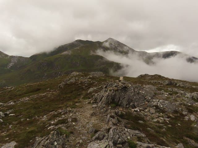
Sgùrr Innse is the rocky cone of the Innse pair — sharper, smaller and more interesting underfoot than Cruach Innse to the north. At 809m it stands a metre below its partner but punches above its weight: the summit is a small rocky tower with serious drops on the south face and a short scrambling step on the standard ascent. Most parties tackle Sgùrr Innse alongside Cruach Innse from the Lairig Leacach for the classic Lochaber Corbett double, and the view from the summit is the best front-row vantage on the Grey Corries that exists anywhere.
Quick facts
- Height
- 809m/ 2654ft
- Prominence
- 216 m
- Distance
- 17 km
- Ascent
- 850 m
- Time
- 5–7 hrs
- Grid ref
- NN290748
- Parking
- NN256807
- Nearest city
- Fort William· 18km
- Dogs
- Dogs on lead required near livestockDog-friendly guide ↗
Height and prominence cross-checked against the Database of British and Irish Hills (CC BY).
No GPX track yet
Walked this route? Share your track to help other walkers.
Standard route
forest track 20% · glen path 25% · steep rocky slope 35% · summit ridge 20%
Start at Corriechoille near Spean Bridge — the same parking point as for Cruach Innse. Forestry track heads south for around 3km, then the stalkers' path runs along the Lairig Leacach. Around 4km in, branch west and climb the steep grass and rock slope onto the north ridge of Sgùrr Innse. A short scramble onto the summit tower. For the classic round, descend north-east to the bealach and reverse-climb Cruach Innse. Allow 6 hours for Sgùrr Innse alone, 8 for the pair.
Terrain
Forestry track and stalkers' path on the approach — easy. The climb onto the hill is steep grass with rock outcrops. The summit tower needs hands for the last few metres: easy scrambling but exposed if you stray off the line. In the wet the rock is glassy.
In winter
Sgùrr Innse in winter is more committing than its unassuming height suggests — the summit scramble becomes a serious step under verglas, the north-facing slope holds wind-deposited snow, and the descent back to the bealach requires care. Many parties skip the summit tower in marginal conditions and stop at the shoulder.
This hill is in the Glen Coe SAIS forecast area. Check SAIS forecasts in winter (December–April).
Best time of year
Getting there
- Glasgow2h 25m
- Edinburgh3h 58m
OS maps: OS Landranger 41
Mobile signal: No signal in the Lairig Leacach/Grey Corries area
Current conditions
Daylight Today
- Sunrise
- 04:45
- Sunset
- 22:05
- Civil dawn
- 03:45
- Civil dusk
- 23:05
NOAA Solar Calculator · 13 July 2026
Pair with
Curated multi-hill combinations from Sgurr Innse.
Around Sgurr Innse on the SCOT network
Getting there, basing yourself, and what to do off the hill.
Getting there: Tulloch station
Loch Treig; Beinn na Lap; Stob Coire Easain / Stob a Choire Mheadhoin approach
6km from the hill
tripscot.co.uk
On TripSCOTBase yourself in Fort William
Ben Nevis base, West Highland Line, gateway to Lochaber
18km from the hill
tripscot.co.uk
On TasteSCOTAfter the hill: Ben Nevis Distillery
Fort William — Lochaber distillery at the foot of the Ben; long-aged Japanese-owned classics
17km from the hill
tastescot.co.uk
Sgurr Innse — common questions
- How hard is Sgurr Innse?
- We grade Sgurr Innse at 3/5, which puts it in moderately challenging territory. The usual route is around 17km with 850m of climbing; allow 5-7 hours. Ground conditions: Forestry track and stalkers' path on the approach — easy.
- How much drop does Sgurr Innse have?
- The drop is 216m: measured from the summit of Sgurr Innse down to the saddle joining it to higher terrain.
- Where's the parking for Sgurr Innse?
- Park at NN256807. Double-check the grid reference on an OS map first; informal laybys here fill early in high season.
- What's the best month to climb Sgurr Innse?
- Aim for April, May, June, July, August, September, October on Sgurr Innse. In the remaining months treat it as a winter hill — full kit, solid navigation, and a look at the relevant SAIS avalanche forecast before you go.
- Can dogs go up Sgurr Innse?
- Dogs are fine on a lead. The route passes livestock or ground-nesting bird habitat, so keep them close throughout.
- Will I get phone signal on Sgurr Innse?
- No signal in the Lairig Leacach/Grey Corries area
- Is Sgurr Innse safe in winter?
- Sgùrr Innse in winter is more committing than its unassuming height suggests — the summit scramble becomes a serious step under verglas, the north-facing slope holds wind-deposited snow, and the descent back to the bealach requires care. Many parties skip the summit tower in marginal conditions and stop at the shoulder.
Get the OutdoorSCOT weekly
One email a week — new route, hill and bothy guides, seasonal conditions and the odd hard-won lesson. No spam, unsubscribe in one click.