Munro · Glen Coe & Lochaber
Stob Coire Easain
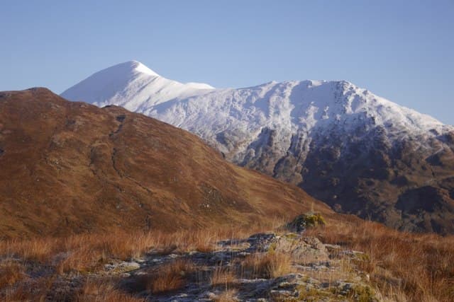
Stob Coire Easain is the 1115m Munro above the north shore of Loch Treig, the higher of the two "Easains" — its smaller twin Stob a' Choire Mheadhoin lies 1km north along the connecting ridge. The pair sits in the quiet country between the Grey Corries and Loch Treig, with the long water of the loch dropping 800m straight down from the summit ridge. With 611m of prominence the hill stands clear of its Grey Corries neighbours via a deep bealach.
Gaelic: “pointed peak, corrie” · Pronunciation: stob kor-a easain
Quick facts
- Height
- 1115m/ 3658ft
- Prominence
- 611 m
- Distance
- ~17 km
- Ascent
- ~981 m
- Time
- 6–9 hrs
- Grid ref
- NN308730
- Parking
- NN350782
- Nearest city
- Fort William· 20km
- Dogs
- Dogs on lead required near livestockDog-friendly guide ↗
Height and prominence cross-checked against the Database of British and Irish Hills (CC BY).
No GPX track yet
Walked this route? Share your track to help other walkers.
Standard route
Loch-side track 30% · Open hillside 35% · Ridge walk 35%
The classic line is from Fersit on the back road into Tulloch, climbing the north ridge of Stob a' Choire Mheadhoin then traversing south to Stob Coire Easain. Around 17km return with 981m of ascent for the pair. The Corrour Station approach from the south is feasible but logistically complex (rail-dependent). Both Easains in one day is the standard outing.
Terrain
The Fersit approach track is firm initially then degrades to rough heather and wet ground beside the Allt Laire. The north ridge of Stob a' Choire Mheadhoin is steep grass and rock; the connecting ridge to Stob Coire Easain is broad grassy walking with no exposure. The summit cairn sits on a small platform with the east face dropping steeply to Loch Treig.
In winter
The east face above Loch Treig holds Grade III-V winter routes. Cornicing on the east edge is consistent. The Fersit track is gritted as far as the road end; the upper ground is exposed to easterly weather. Phone signal absent above the road.
Kit for this: the winter Munro kit list · which boots take crampons
Best time of year
Getting there
- Glasgow2h 22m
- Edinburgh3h 55m
OS maps: OS Landranger 41
Mobile signal: No signal on the ridge above Loch Treig. Tulloch station car park has intermittent signal. The Corrour approach from Fersit is remote with no coverage at all above 600m.
Current conditions
Daylight Today
- Sunrise
- 08:08
- Sunset
- 17:59
- Civil dawn
- 07:29
- Civil dusk
- 18:38
NOAA Solar Calculator · 23 October 2026
Pair with
Curated multi-hill combinations from Stob Coire Easain.
Around Stob Coire Easain on the SCOT network
Getting there, basing yourself, and what to do off the hill.
Stob Coire Easain — common questions
- How hard is Stob Coire Easain?
- We grade Stob Coire Easain at 3/5, which puts it in moderately challenging territory. The usual route is around 17km with 981m of climbing; allow 6-9 hours. Underfoot: The Fersit approach track is firm initially then degrades to rough heather and wet ground beside the Allt Laire.
- What is Stob Coire Easain's prominence?
- 611m of prominence. That's the vertical drop from the summit to the col that links Stob Coire Easain to the next higher ground.
- Where do I park for Stob Coire Easain?
- Most walkers start from NN350782. Verify the grid reference on an OS map before you set off — space is tight on busy summer weekends.
- When is the best time to climb Stob Coire Easain?
- May, June, July, August, September, October give the most reliable conditions on Stob Coire Easain. Beyond that window the high ground turns wintry: carry full mountain kit, be confident navigating, and check the SAIS avalanche forecast for the area.
- Is Stob Coire Easain dog-friendly?
- Yes, but dogs must be kept on a lead — there is livestock or ground-nesting bird interest on the route.
- Is there mobile signal on Stob Coire Easain?
- No signal on the ridge above Loch Treig. Tulloch station car park has intermittent signal. The Corrour approach from Fersit is remote with no coverage at all above 600m.
- Is Stob Coire Easain safe in winter?
- The east face above Loch Treig holds Grade III-V winter routes. Cornicing on the east edge is consistent. The Fersit track is gritted as far as the road end; the upper ground is exposed to easterly weather. Phone signal absent above the road.
Get the OutdoorSCOT weekly
One email a week — new route, hill and bothy guides, seasonal conditions and the odd hard-won lesson. No spam, unsubscribe in one click.