Graham · Glen Coe & Lochaber
Creag Ghuanach
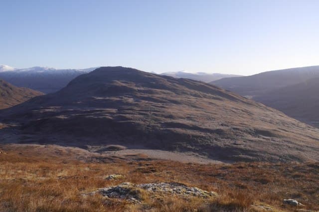
Creag Ghuanach (621m), the rocky crag of unease, is a small rocky knoll above the head of Loch Treig in the NN29 square. Its cairn looks across the loch to the great whaleback of Stob Coire Easain and back along Strath Ossian toward the Corrour deer forest. The remoteness of the setting makes the modest top feel earned even though the climb is short.
Quick facts
- Height
- 621m/ 2037ft
- Prominence
- 212 m
- Distance
- 12 km
- Ascent
- 466 m
- Time
- 3–5 hrs
- Grid ref
- NN299690
- Parking
- NN284689
- Nearest city
- Fort William· 20km
- Dogs
- Dogs on lead required near livestockDog-friendly guide ↗
Height and prominence cross-checked against the Database of British and Irish Hills (CC BY).
No GPX track yet
Walked this route? Share your track to help other walkers.
Standard route
heather moorland 60% · rocky hillside 25% · bog and wet grass 15%
The usual approach is on foot or bike from Corrour station, taking the estate track south-west to the loch head and then climbing the short crag-broken east flank. About six hours round trip from Corrour; longer if walking in via the Lairig Leacach from Fersit. The descent reverses the climb — the west side falls in tiers of broken crag.
Terrain
Loch-side heather and a steep little crag-step define the climb. The summit knoll is firm rock with grass between blocks. Avoid the west face which drops abruptly to the lochside flats; the cleanest descent is back the way you came.
In winter
Loch Treig sits in a frosty hollow and Creag Ghuanach catches verglas readily on its short crag-step. The walk in along the loch is on a level track but is exposed to north winds funnelling down from Aonach Beag. Daylight is short and a midwinter visit needs an early train to Corrour and a careful eye on the return.
This hill is in the Glen Coe SAIS forecast area. Check SAIS forecasts in winter (December–April).
Best time of year
Getting there
- Glasgow2h 17m
- Edinburgh3h 52m
OS maps: OS Landranger 41
Mobile signal: Poor. Remote Loch Treig/Corrour area; very limited coverage.
Current conditions
Daylight Today
- Sunrise
- 04:52
- Sunset
- 21:59
- Civil dawn
- 03:54
- Civil dusk
- 22:57
NOAA Solar Calculator · 17 July 2026
Around Creag Ghuanach on the SCOT network
Getting there, basing yourself, and what to do off the hill.
Getting there: Corrour station
Highest mainline station; Loch Ossian, Ben Alder, Aonach Beag (Alder)
6km from the hill
tripscot.co.uk
On TripSCOTBase yourself in Fort William
Ben Nevis base, West Highland Line, gateway to Lochaber
20km from the hill
tripscot.co.uk
On TasteSCOTAfter the hill: Ben Nevis Distillery
Fort William — Lochaber distillery at the foot of the Ben; long-aged Japanese-owned classics
19km from the hill
tastescot.co.uk
Creag Ghuanach — common questions
- What difficulty is Creag Ghuanach?
- On the OutdoorSCOT scale, Creag Ghuanach comes in at 3/5 — moderately challenging. Expect roughly 12km and 466m of ascent on the usual route — 3-5 hours for most parties. Underfoot: Loch-side heather and a steep little crag-step define the climb.
- What is Creag Ghuanach's prominence?
- 212m of prominence. That's the vertical drop from the summit to the col that links Creag Ghuanach to the next higher ground.
- Where do I park for Creag Ghuanach?
- Most walkers start from NN284689. Verify the grid reference on an OS map before you set off — space is tight on busy summer weekends.
- When is the best time to climb Creag Ghuanach?
- March, April, May, June, July, August, September, October, November give the most reliable conditions on Creag Ghuanach. Beyond that window the high ground turns wintry: carry full mountain kit, be confident navigating, and check the SAIS avalanche forecast for the area.
- Is Creag Ghuanach dog-friendly?
- Yes, but dogs must be kept on a lead — there is livestock or ground-nesting bird interest on the route.
- Is there mobile signal on Creag Ghuanach?
- Poor. Remote Loch Treig/Corrour area; very limited coverage.
- Is Creag Ghuanach safe in winter?
- Loch Treig sits in a frosty hollow and Creag Ghuanach catches verglas readily on its short crag-step. The walk in along the loch is on a level track but is exposed to north winds funnelling down from Aonach Beag. Daylight is short and a midwinter visit needs an early train to Corrour and a careful eye on the return.
Get the OutdoorSCOT weekly
One email a week — new route, hill and bothy guides, seasonal conditions and the odd hard-won lesson. No spam, unsubscribe in one click.