Graham · Glen Coe & Lochaber
Beinn na Cloiche
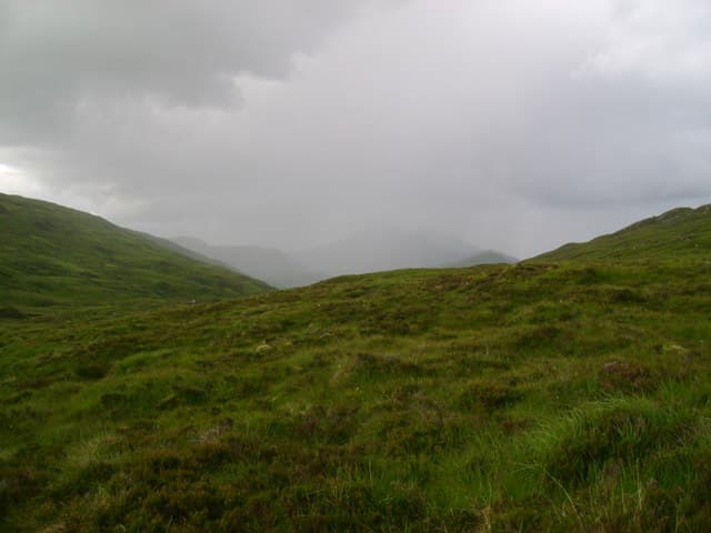
Beinn na Cloiche (645m) — the stone hill — sits in the NN26 square above the Allt Cam Ban, between Loch Treig and the Lairig Leacach. A cairn on a quartzite outcrop marks the top, with the Easains and Stob Coire Easain rising to the north and Stob Ban's pale flank gleaming nearby.
Quick facts
- Height
- 645.1m/ 2116ft
- Prominence
- 193 m
- Distance
- 12 km
- Ascent
- 484 m
- Time
- 3–5 hrs
- Grid ref
- NN284648
- Parking
- NN251806
- Nearest city
- Fort William· 20km
- Dogs
- Dogs on lead required near livestockDog-friendly guide ↗
Height and prominence cross-checked against the Database of British and Irish Hills (CC BY).
No GPX track yet
Walked this route? Share your track to help other walkers.
Standard route
heather and bog 60% · grass slopes 25% · rocky summit 15%
Start from the parking at Corriechoille at the south end of the Lairig Leacach track. Follow the well-graded track south-east into the Lairig, then leave it after four kilometres on a quad rut climbing east. Once on the broad shoulder, follow the watershed south-east to the quartzite outcrop and cairn.
Terrain
Excellent Lairig Leacach track for the first stage, then trackless tussock and quartzite slabs on the upper slopes. The outcrop summit is a fine perch but the surrounding watershed is broad and unfeatured beyond it.
In winter
The Lairig Leacach corridor receives heavy Lochaber snow and the quartzite outcrops glaze with rime in cold spells. Beinn na Cloiche has no avalanche-prone steep ground itself but the approach passes beneath busier slopes. SAIS Creag Meagaidh forecasts apply here.
This hill is in the Glen Coe SAIS forecast area. Check SAIS forecasts in winter (December–April).
Best time of year
Getting there
- Glasgow2h 13m
- Edinburgh3h 50m
OS maps: OS Landranger 41
Mobile signal: Poor. Remote Lairig Leacach / Corriechoille area; weak on most networks.
Current conditions
Daylight Today
- Sunrise
- 04:46
- Sunset
- 22:04
- Civil dawn
- 03:46
- Civil dusk
- 23:04
NOAA Solar Calculator · 13 July 2026
Around Beinn na Cloiche on the SCOT network
Getting there, basing yourself, and what to do off the hill.
Getting there: Corrour station
Highest mainline station; Loch Ossian, Ben Alder, Aonach Beag (Alder)
7km from the hill
tripscot.co.uk
On TripSCOTBase yourself in Fort William
Ben Nevis base, West Highland Line, gateway to Lochaber
20km from the hill
tripscot.co.uk
On TasteSCOTAfter the hill: Ben Nevis Distillery
Fort William — Lochaber distillery at the foot of the Ben; long-aged Japanese-owned classics
20km from the hill
tastescot.co.uk
Beinn na Cloiche — common questions
- What difficulty is Beinn na Cloiche?
- On the OutdoorSCOT scale, Beinn na Cloiche comes in at 3/5 — moderately challenging. Expect roughly 12km and 484m of ascent on the usual route — 3-5 hours for most parties. Underfoot: Excellent Lairig Leacach track for the first stage, then trackless tussock and quartzite slabs on the upper slopes.
- What is Beinn na Cloiche's prominence?
- 193m of prominence. That's the vertical drop from the summit to the col that links Beinn na Cloiche to the next higher ground.
- Where do I park for Beinn na Cloiche?
- Most walkers start from NN251806. Verify the grid reference on an OS map before you set off — space is tight on busy summer weekends.
- When is the best time to climb Beinn na Cloiche?
- March, April, May, June, July, August, September, October, November give the most reliable conditions on Beinn na Cloiche. Beyond that window the high ground turns wintry: carry full mountain kit, be confident navigating, and check the SAIS avalanche forecast for the area.
- Is Beinn na Cloiche dog-friendly?
- Yes, but dogs must be kept on a lead — there is livestock or ground-nesting bird interest on the route.
- Is there mobile signal on Beinn na Cloiche?
- Poor. Remote Lairig Leacach / Corriechoille area; weak on most networks.
- Is Beinn na Cloiche safe in winter?
- The Lairig Leacach corridor receives heavy Lochaber snow and the quartzite outcrops glaze with rime in cold spells. Beinn na Cloiche has no avalanche-prone steep ground itself but the approach passes beneath busier slopes. SAIS Creag Meagaidh forecasts apply here.
Get the OutdoorSCOT weekly
One email a week — new route, hill and bothy guides, seasonal conditions and the odd hard-won lesson. No spam, unsubscribe in one click.