Graham · Glen Coe & Lochaber
Pap of Glencoe
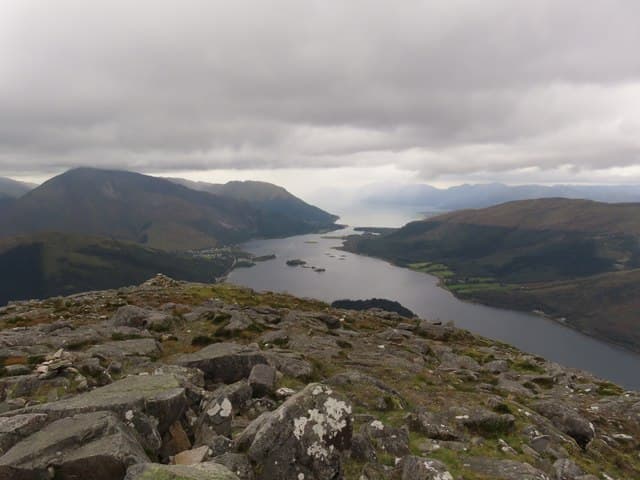
Sgorr na Ciche, the famous breast-shaped peak rising at the western end of the Aonach Eagach ridge directly above Glencoe village and Loch Leven. Tiny in height for its visual impact, it is the most photographed minor summit in Lochaber.
Quick facts
- Height
- 742.4m/ 2436ft
- Prominence
- 156 m
- Distance
- 14 km
- Ascent
- 608 m
- Time
- 4–7 hrs
- Grid ref
- NN125594
- Parking
- NN101591
- Nearest city
- Fort William· 15km
- Dogs
- Dogs on lead required near livestockDog-friendly guide ↗
Height and prominence cross-checked against the Database of British and Irish Hills (CC BY).
No GPX track yet
Walked this route? Share your track to help other walkers.
Standard route
village path 15% · steep grass 40% · rocky upper section 30% · summit area 15%
Start from the path beside the war memorial at the east end of Glencoe village, climb steeply on a worn line through birch and bracken, then zigzag up the south-east shoulder to the foot of the cone. The final pull is loose scree to the small summit.
Terrain
Heavily eroded path on the lower slopes — slippery wet grass in rain. Final cone is steep loose stones and small rock steps requiring care.
In winter
The conical summit can ice up dramatically after a clearance and the loose scree becomes consolidated neve. Aonach Eagach SAIS area applies — windslab on the connecting ridge if continuing east.
This hill is in the Glen Coe SAIS forecast area. Check SAIS forecasts in winter (December–April).
Best time of year
Getting there
- Glasgow2h 14m
- Edinburgh3h 1m
OS maps: OS Landranger 41
Mobile signal: Good signal near Glencoe village; around 2-3 bars on top above the village
Current conditions
Daylight Today
- Sunrise
- 04:47
- Sunset
- 22:05
- Civil dawn
- 03:48
- Civil dusk
- 23:04
NOAA Solar Calculator · 13 July 2026
Pair with
Curated multi-hill combinations from Pap of Glencoe.
Around Pap of Glencoe on the SCOT network
Getting there, basing yourself, and what to do off the hill.
Getting there: Fort William station
Ben Nevis, Mamores, Aonachs, Knoydart ferry connection
14km from the hill
tripscot.co.uk
On TripSCOTBase yourself in Fort William
Ben Nevis base, West Highland Line, gateway to Lochaber
15km from the hill
tripscot.co.uk
On TasteSCOTAfter the hill: Ben Nevis Distillery
Fort William — Lochaber distillery at the foot of the Ben; long-aged Japanese-owned classics
17km from the hill
tastescot.co.uk
Pap of Glencoe — common questions
- How hard is Pap of Glencoe?
- We grade Pap of Glencoe at 4/5, which puts it in challenging territory. The usual route is around 14km with 608m of climbing; allow 4-7 hours. Underfoot: Heavily eroded path on the lower slopes — slippery wet grass in rain.
- What is Pap of Glencoe's prominence?
- 156m of prominence. That's the vertical drop from the summit to the col that links Pap of Glencoe to the next higher ground.
- Where do I park for Pap of Glencoe?
- Most walkers start from NN101591. Verify the grid reference on an OS map before you set off — space is tight on busy summer weekends.
- When is the best time to climb Pap of Glencoe?
- April, May, June, July, August, September, October give the most reliable conditions on Pap of Glencoe. Beyond that window the high ground turns wintry: carry full mountain kit, be confident navigating, and check the SAIS avalanche forecast for the area.
- Is Pap of Glencoe dog-friendly?
- Yes, but dogs must be kept on a lead — there is livestock or ground-nesting bird interest on the route.
- Is there mobile signal on Pap of Glencoe?
- Good signal near Glencoe village; around 2-3 bars on top above the village
- Is Pap of Glencoe safe in winter?
- The conical summit can ice up dramatically after a clearance and the loose scree becomes consolidated neve. Aonach Eagach SAIS area applies — windslab on the connecting ridge if continuing east.
Get the OutdoorSCOT weekly
One email a week — new route, hill and bothy guides, seasonal conditions and the odd hard-won lesson. No spam, unsubscribe in one click.