Graham · Glen Coe & Lochaber
Tom Meadhoin
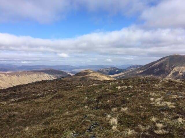
Tom Meadhoin (621m), the middle knoll, lifts above Kinlochleven in the NN06 square between Loch Leven and the Mamores. The summit is a rock cushion in grass at the end of a gentle ridge running east from the village. The view down Loch Leven is one of the best gifts of a hill this size, with the Glen Coe tops and the south side of the Mamores filling the horizon.
Quick facts
- Height
- 621.8m/ 2040ft
- Prominence
- 156 m
- Distance
- 12 km
- Ascent
- 466 m
- Time
- 3–5 hrs
- Grid ref
- NN087621
- Parking
- NN100623
- Nearest city
- Fort William· 12km
- Dogs
- Dogs on lead required near livestockDog-friendly guide ↗
Height and prominence cross-checked against the Database of British and Irish Hills (CC BY).
No GPX track yet
Walked this route? Share your track to help other walkers.
Standard route
heather moorland 65% · grass slopes 25% · rocky summit 10%
From Kinlochleven car park at NN100623 follow the West Highland Way signs out of the village onto the old military road. After about a kilometre branch onto a forest track climbing east, then leave it for the open hillside as the trees thin. The summit knob is reached in three to four hours round trip. Take care on the descent through the forestry, which has many criss-crossing tracks.
Terrain
Forestry tracks for the first half-hour give way to heather and bracken on the open hillside. The upper ridge is a sequence of grass-and-rock terraces, easy to walk and pleasant in summer. The Allt na Sguabaidh on the south side runs in a steep gorge — keep clear of its lip.
In winter
Kinlochleven is one of the wettest spots in Scotland and Tom Meadhoin's rock terraces ice over readily. The forestry tracks become greasy underfoot in shaded sections. The hill is well suited to a short midwinter day if conditions are settled, but the Mamores SAIS forecast is the right reference for upper-slope avalanche conditions.
This hill is in the Glen Coe SAIS forecast area. Check SAIS forecasts in winter (December–April).
Best time of year
Getting there
- Glasgow2h 19m
- Edinburgh3h 7m
OS maps: OS Landranger 41
Mobile signal: Good in Kinlochleven; patchy on the upper hill.
Current conditions
Daylight Today
- Sunrise
- 04:53
- Sunset
- 22:00
- Civil dawn
- 03:56
- Civil dusk
- 22:58
NOAA Solar Calculator · 17 July 2026
Around Tom Meadhoin on the SCOT network
Getting there, basing yourself, and what to do off the hill.
Getting there: Fort William station
Ben Nevis, Mamores, Aonachs, Knoydart ferry connection
12km from the hill
tripscot.co.uk
On TripSCOTBase yourself in Fort William
Ben Nevis base, West Highland Line, gateway to Lochaber
12km from the hill
tripscot.co.uk
On TasteSCOTAfter the hill: Ben Nevis Distillery
Fort William — Lochaber distillery at the foot of the Ben; long-aged Japanese-owned classics
14km from the hill
tastescot.co.uk
Tom Meadhoin — common questions
- What difficulty is Tom Meadhoin?
- On the OutdoorSCOT scale, Tom Meadhoin comes in at 3/5 — moderately challenging. Expect roughly 12km and 466m of ascent on the usual route — 3-5 hours for most parties. Terrain: Forestry tracks for the first half-hour give way to heather and bracken on the open hillside.
- How prominent is Tom Meadhoin?
- Tom Meadhoin has 156m of topographic prominence — the height of its summit above the highest col connecting it to higher ground.
- Where should I park to climb Tom Meadhoin?
- Standard parking is at NN100623. Check the parking grid reference on an OS map before travel; informal laybys can fill on summer weekends.
- When should I climb Tom Meadhoin?
- The standard good-weather months for Tom Meadhoin are March, April, May, June, July, August, September, October, November. Outside those months, expect winter conditions on the high ground — full mountain kit, navigation skills, and a check of the SAIS avalanche forecast for the relevant region.
- Can I bring my dog up Tom Meadhoin?
- On a lead only — the route crosses ground with livestock or nesting-bird interest.
- What's mobile reception like on Tom Meadhoin?
- Good in Kinlochleven; patchy on the upper hill.
- Is Tom Meadhoin safe in winter?
- Kinlochleven is one of the wettest spots in Scotland and Tom Meadhoin's rock terraces ice over readily. The forestry tracks become greasy underfoot in shaded sections. The hill is well suited to a short midwinter day if conditions are settled, but the Mamores SAIS forecast is the right reference for upper-slope avalanche conditions.
Get the OutdoorSCOT weekly
One email a week — new route, hill and bothy guides, seasonal conditions and the odd hard-won lesson. No spam, unsubscribe in one click.