Munro · Glen Coe & Lochaber
Beinn a' Bheithir - Sgorr Dhearg
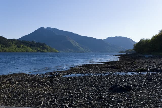
Sgorr Dhearg (1024m) — "red peak" — is the higher of the two Munros that make up Beinn a' Bheithir, the elegant horseshoe of summits standing on the south side of the Ballachulish narrows. Visible to every traveller heading north on the A82 from Glencoe, the mountain forms a magnificent backdrop to Loch Linnhe. The traverse of both Munros (Sgorr Dhearg and Sgorr Dhonuill) is one of the great short Argyll ridge walks with seaward views across to Mull and Morvern.
Quick facts
- Height
- 1024.2m/ 3360ft
- Prominence
- 729 m
- Distance
- 17 km
- Ascent
- 901 m
- Time
- 5–8 hrs
- Grid ref
- NN056558
- Parking
- NN036586
- Nearest city
- Fort William· 19km
- Dogs
- Dogs on lead required near livestockDog-friendly guide ↗
Height and prominence cross-checked against the Database of British and Irish Hills (CC BY).
No GPX track yet
Walked this route? Share your track to help other walkers.
Standard route
Forest path 25% · Open hillside 35% · Summit ridge 40%
Start from the parking area at the end of the forestry road south of Ballachulish (above the Ballachulish Quarry). Walk east on the forest track, then take the path that climbs steeply south through clear-felled forestry onto Sgorr Bhan, the prominent north-east outlier. Continue south-west along the narrow connecting ridge to Sgorr Dhearg. Most parties continue west over the high bealach to Sgorr Dhonuill, then descend the north-west ridge through the forest. Around 11km with 1300m of ascent for the pair.
Terrain
The forestry access tracks are firm but the routes through the trees can be muddy after rain. The climb onto Sgorr Bhan is steep heathery hillside with one or two short rocky steps higher up. The connecting ridge between Sgorr Bhan, Sgorr Dhearg and Sgorr Dhonuill is narrow with sustained airy walking — exposure on both sides, particularly on the Sgorr Bhan section. The summit of Dhearg is a tiny pointed top. The Dhonuill descent through forest is wet and rooty.
In winter
A serious west-coast winter ridge. The connecting crest between the three tops develops continuous cornicing on both sides and becomes a sustained narrow winter walk. The north corries above Loch Leven hold significant avalanche risk after westerly storms. The forestry access can be drifted. The A82 corridor at Ballachulish stays gritted. SAIS Glencoe applies. Phone signal weakens above 700m.
This hill is in the Glen Coe SAIS forecast area. Check SAIS forecasts in winter (December–April).
Best time of year
Getting there
- Glasgow2h 14m
- Edinburgh3h 5m
OS maps: OS Landranger 41
Mobile signal: Reasonable signal in Ballachulish village. Signal weakens to patchy above 700m on the Beinn a' Bheithir ridges. Download maps before heading up.
Current conditions
Daylight Today
- Sunrise
- 05:04
- Sunset
- 21:50
- Civil dawn
- 04:10
- Civil dusk
- 22:45
NOAA Solar Calculator · 23 July 2026
Pair with
Curated multi-hill combinations from Beinn a' Bheithir - Sgorr Dhearg.
Around Beinn a' Bheithir - Sgorr Dhearg on the SCOT network
Getting there, basing yourself, and what to do off the hill.
Getting there: Fort William station
Ben Nevis, Mamores, Aonachs, Knoydart ferry connection
19km from the hill
tripscot.co.uk
On TripSCOTBase yourself in Fort William
Ben Nevis base, West Highland Line, gateway to Lochaber
19km from the hill
tripscot.co.uk
On TasteSCOTAfter the hill: Ben Nevis Distillery
Fort William — Lochaber distillery at the foot of the Ben; long-aged Japanese-owned classics
21km from the hill
tastescot.co.uk
Beinn a' Bheithir - Sgorr Dhearg — common questions
- What difficulty is Beinn a' Bheithir - Sgorr Dhearg?
- On the OutdoorSCOT scale, Beinn a' Bheithir - Sgorr Dhearg comes in at 4/5 — challenging. Expect roughly 17km and 901m of ascent on the usual route — 5-8 hours for most parties. Terrain: The forestry access tracks are firm but the routes through the trees can be muddy after rain.
- How prominent is Beinn a' Bheithir - Sgorr Dhearg?
- Beinn a' Bheithir - Sgorr Dhearg has 729m of topographic prominence — the height of its summit above the highest col connecting it to higher ground.
- Where should I park to climb Beinn a' Bheithir - Sgorr Dhearg?
- Standard parking is at NN036586. Check the parking grid reference on an OS map before travel; informal laybys can fill on summer weekends.
- When should I climb Beinn a' Bheithir - Sgorr Dhearg?
- The standard good-weather months for Beinn a' Bheithir - Sgorr Dhearg are May, June, July, August, September, October. Outside those months, expect winter conditions on the high ground — full mountain kit, navigation skills, and a check of the SAIS avalanche forecast for the relevant region.
- Can I bring my dog up Beinn a' Bheithir - Sgorr Dhearg?
- On a lead only — the route crosses ground with livestock or nesting-bird interest.
- What's mobile reception like on Beinn a' Bheithir - Sgorr Dhearg?
- Reasonable signal in Ballachulish village. Signal weakens to patchy above 700m on the Beinn a' Bheithir ridges. Download maps before heading up.
- Is Beinn a' Bheithir - Sgorr Dhearg safe in winter?
- A serious west-coast winter ridge. The connecting crest between the three tops develops continuous cornicing on both sides and becomes a sustained narrow winter walk. The north corries above Loch Leven hold significant avalanche risk after westerly storms. The forestry access can be drifted. The A82 corridor at Ballachulish stays gritted. SAIS Glencoe applies. Phone signal weakens above 700m.
Get the OutdoorSCOT weekly
One email a week — new route, hill and bothy guides, seasonal conditions and the odd hard-won lesson. No spam, unsubscribe in one click.