Corbett · Morvern
Fraochaidh
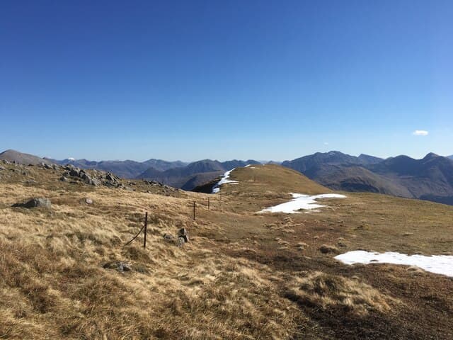
Fraochaidh is the highest of the hills hidden between Glen Duror and Glen Creran in Appin, south-west of Ballachulish. It is a quiet hill on a busy stretch of the west coast — most travellers heading up the A828 are too focused on Glen Coe ahead to notice it. With 551m of prominence and a complex undulating ridge, it gives one of the most worthwhile Corbett days in this corner of Argyll. The summit cairn looks out over Loch Linnhe to Morvern and north to the Pap of Glencoe and Bidean nam Bian.
Quick facts
- Height
- 879m/ 2884ft
- Prominence
- 551 m
- Distance
- 16 km
- Ascent
- 774 m
- Time
- 5–8 hrs
- Grid ref
- NN029517
- Parking
- NM992551
- Nearest city
- Fort William· 24km
- Dogs
- Dogs on lead required near livestockDog-friendly guide ↗
Height and prominence cross-checked against the Database of British and Irish Hills (CC BY).
No GPX track yet
Walked this route? Share your track to help other walkers.
Standard route
forest track 25% · boggy moor 20% · broad ridge 45% · summit dome 10%
Start from the small car park at Achara, just east of Duror on the A828, and follow the path north through Forestry Land onto open hillside above Achindarroch. A long undulating ridge runs west then north-west over a series of bumps and a deep bealach before the final pull onto Fraochaidh. Around 16km return with 774m of ascent net of re-ascents over the intermediate tops. Return by the same route — the south-west descent into Glen Creran is rough and ends in deer fence.
Terrain
Through the forest the track is firm but the transition onto open hill is boggy and pathless for the first kilometre. The connecting ridge is broad and grassy with rocky outcrops on the bumps — straightforward in clear weather but disorientating in mist where the multiple sub-tops make it easy to drop onto the wrong descent line. Watch for forestry felling operations on the lower slopes; signs reroute walkers when active.
In winter
A relatively low Corbett but its position close to the coast and west-facing aspect mean it catches the full force of Atlantic systems. Snow cover is rarely deep but the ridge develops icy patches that the broad open ground hides until stepped on. In a thaw the forestry section becomes seriously muddy. The shorter winter day rules out any temptation to extend over the western tops.
This hill is in the Glen Coe SAIS forecast area. Check SAIS forecasts in winter (December–April).
Best time of year
Getting there
- Glasgow2h 11m
- Edinburgh3h 5m
OS maps: OS Landranger 41
Mobile signal: No signal in Glen Etive; possible brief coverage near Bunawe on descent
Current conditions
Daylight Today
- Sunrise
- 04:48
- Sunset
- 22:05
- Civil dawn
- 03:49
- Civil dusk
- 23:04
NOAA Solar Calculator · 13 July 2026
Pair with
Curated multi-hill combinations from Fraochaidh.
Around Fraochaidh on the SCOT network
Getting there, basing yourself, and what to do off the hill.
Getting there: Fort William station
Ben Nevis, Mamores, Aonachs, Knoydart ferry connection
23km from the hill
tripscot.co.uk
On TripSCOTBase yourself in Fort William
Ben Nevis base, West Highland Line, gateway to Lochaber
24km from the hill
tripscot.co.uk
On TasteSCOTAfter the hill: Ben Nevis Distillery
Fort William — Lochaber distillery at the foot of the Ben; long-aged Japanese-owned classics
26km from the hill
tastescot.co.uk
Fraochaidh — common questions
- How hard is Fraochaidh?
- We grade Fraochaidh at 3/5, which puts it in moderately challenging territory. The usual route is around 16km with 774m of climbing; allow 5-8 hours. Ground conditions: Through the forest the track is firm but the transition onto open hill is boggy and pathless for the first kilometre.
- How much drop does Fraochaidh have?
- The drop is 551m: measured from the summit of Fraochaidh down to the saddle joining it to higher terrain.
- Where's the parking for Fraochaidh?
- Park at NM992551. Double-check the grid reference on an OS map first; informal laybys here fill early in high season.
- What's the best month to climb Fraochaidh?
- Aim for May, June, July, August, September, October on Fraochaidh. In the remaining months treat it as a winter hill — full kit, solid navigation, and a look at the relevant SAIS avalanche forecast before you go.
- Can dogs go up Fraochaidh?
- Dogs are fine on a lead. The route passes livestock or ground-nesting bird habitat, so keep them close throughout.
- Will I get phone signal on Fraochaidh?
- No signal in Glen Etive; possible brief coverage near Bunawe on descent
- Is Fraochaidh safe in winter?
- A relatively low Corbett but its position close to the coast and west-facing aspect mean it catches the full force of Atlantic systems. Snow cover is rarely deep but the ridge develops icy patches that the broad open ground hides until stepped on. In a thaw the forestry section becomes seriously muddy. The shorter winter day rules out any temptation to extend over the western tops.
Get the OutdoorSCOT weekly
One email a week — new route, hill and bothy guides, seasonal conditions and the odd hard-won lesson. No spam, unsubscribe in one click.