Corbett · Glen Coe
Meall Lighiche
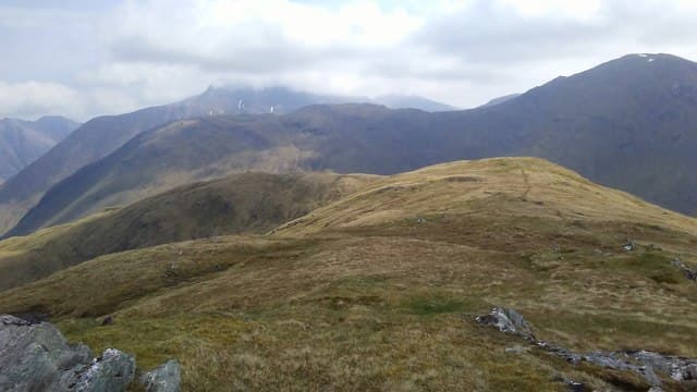
Meall Lighiche — 'the physician's hill' — is the rounded 772m Corbett rising between Glen Etive and Glen Creran, set in the quieter country south-west of the main Glen Coe Munros. The mountain is overshadowed by its neighbours — Sgor na h-Ulaidh and Stob a' Choin Dubh to the north, Beinn Sgulaird to the south — and is often climbed by Munro-baggers as a quick add-on after Sgor na h-Ulaidh. The summit gives an open view down Glen Creran to Loch Creran and across to Bidean nam Bian on the far side of Glen Etive.
Quick facts
- Height
- 772m/ 2533ft
- Prominence
- 247 m
- Distance
- 11 km
- Ascent
- 700 m
- Time
- 3–5 hrs
- Grid ref
- NN094528
- Parking
- NN035484
- Nearest city
- Fort William· 21km
- Dogs
- Dogs on lead required near livestockDog-friendly guide ↗
Height and prominence cross-checked against the Database of British and Irish Hills (CC BY).
No GPX track yet
Walked this route? Share your track to help other walkers.
Standard route
glen access 15% · heather hillside 50% · grassy ridge 25% · summit area 10%
From the head of Glen Creran, park in the small lay-by on the minor road just south of Invercreran (NN035484). Walk north up the estate track that runs into the bealach between Meall Lighiche and Sgor na h-Ulaidh. About 3km up the glen, leave the track and climb east up the broad south-west flank of Meall Lighiche. A steady plod on grass and heather gains the modest summit cairn. Allow 5–6 hours.
Terrain
A serviceable estate track covers the lower approach. Beyond it the underlying ground is heather and grass with peat hag in the bealach. The top opens out as wide turf with a low cairn marking the high point. Drier than the Glen Etive average because the hill sits in a partial rain shadow from the Bidean massif.
In winter
A friendly winter Corbett by Glen Coe standards — gentle gradients keep the ascent line clear of avalanche-prone ground, and the north-east aspect holds reliable snow cover. The Glen Creran road is narrow but generally accessible. Cold easterlies from the Bidean massif can be ferocious on the broad summit; carry a windproof.
This hill is in the Glen Coe SAIS forecast area. Check SAIS forecasts in winter (December–April).
Best time of year
Getting there
- Glasgow2h 8m
- Edinburgh3h 59m
OS maps: OS Landranger 41
Mobile signal: EE/Vodafone usable at Invercreran; weakens through the glen; no signal on the summit or in the upper bealach
Current conditions
Daylight Today
- Sunrise
- 04:48
- Sunset
- 22:05
- Civil dawn
- 03:48
- Civil dusk
- 23:04
NOAA Solar Calculator · 13 July 2026
Pair with
Curated multi-hill combinations from Meall Lighiche.
Around Meall Lighiche on the SCOT network
Getting there, basing yourself, and what to do off the hill.
Getting there: Fort William station
Ben Nevis, Mamores, Aonachs, Knoydart ferry connection
21km from the hill
tripscot.co.uk
On TripSCOTBase yourself in Fort William
Ben Nevis base, West Highland Line, gateway to Lochaber
21km from the hill
tripscot.co.uk
On TasteSCOTAfter the hill: Ben Nevis Distillery
Fort William — Lochaber distillery at the foot of the Ben; long-aged Japanese-owned classics
23km from the hill
tastescot.co.uk
Meall Lighiche — common questions
- Is Meall Lighiche a hard climb?
- Meall Lighiche is rated 2/5 (moderate) on the OutdoorSCOT scale. The standard route covers about 11km with 700m of ascent and takes most walkers 3-5 hours. Underfoot: A serviceable estate track covers the lower approach.
- What is Meall Lighiche's prominence?
- 247m of prominence. That's the vertical drop from the summit to the col that links Meall Lighiche to the next higher ground.
- Where do I park for Meall Lighiche?
- Most walkers start from NN035484. Verify the grid reference on an OS map before you set off — space is tight on busy summer weekends.
- When is the best time to climb Meall Lighiche?
- April, May, June, July, August, September, October give the most reliable conditions on Meall Lighiche. Beyond that window the high ground turns wintry: carry full mountain kit, be confident navigating, and check the SAIS avalanche forecast for the area.
- Is Meall Lighiche dog-friendly?
- Yes, but dogs must be kept on a lead — there is livestock or ground-nesting bird interest on the route.
- Is there mobile signal on Meall Lighiche?
- EE/Vodafone usable at Invercreran; weakens through the glen; no signal on the summit or in the upper bealach
- Is Meall Lighiche safe in winter?
- A friendly winter Corbett by Glen Coe standards — gentle gradients keep the ascent line clear of avalanche-prone ground, and the north-east aspect holds reliable snow cover. The Glen Creran road is narrow but generally accessible. Cold easterlies from the Bidean massif can be ferocious on the broad summit; carry a windproof.
Get the OutdoorSCOT weekly
One email a week — new route, hill and bothy guides, seasonal conditions and the odd hard-won lesson. No spam, unsubscribe in one click.