Corbett · Glen Coe
Beinn Maol Chaluim
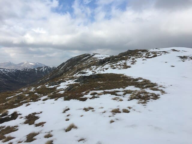
Beinn Maol Chaluim is the 906m Corbett standing directly south of Bidean nam Bian on the east side of Glen Etive. The mountain is overshadowed by its giant Munro neighbour — Bidean is the highest in Argyll — and rarely climbed for its own sake. The summit lies at the south end of a long broad ridge running down from Bidean's Stob Coire nan Lochan top. Most parties combine it with Bidean as part of a long Glen Etive horseshoe, although the Corbett stands alone on the standard list.
Quick facts
- Height
- 906.3m/ 2973ft
- Prominence
- 197 m
- Distance
- 11 km
- Ascent
- 920 m
- Time
- 3–6 hrs
- Grid ref
- NN134525
- Parking
- NN135453
- Nearest city
- Fort William· 22km
- Dogs
- Dogs on lead required near livestockDog-friendly guide ↗
Height and prominence cross-checked against the Database of British and Irish Hills (CC BY).
No GPX track yet
Walked this route? Share your track to help other walkers.
Standard route
glen floor 15% · steep grass 45% · rocky upper slopes 30% · summit plateau 10%
Park at the small parking area on the Glen Etive road near Invercharnan (NN135453), some 14km down the glen from the A82. Cross the river by the bridge and follow the path up the south bank for around 2km, then climb the steep south-east face of Beinn Maol Chaluim directly. The route gains the summit ridge after a sustained pull. Descent reverses the line. Allow 5–6 hours.
Terrain
Glen Etive road is single-track and narrow — parking can be tight in busy weekends. The hillside is steep grass with rocky outcrops; the ascent is short on horizontal distance but unrelenting in gradient. The summit ridge is broad and rocky with a small cairn. The connecting ridge to Bidean nam Bian is rough and committing.
In winter
Beinn Maol Chaluim in winter is a serious snow climb on the steep east face. The Glen Etive road can be slow when iced. The connecting ridge to Bidean is a Grade I winter route in good conditions — fine extension for parties with axe and crampon experience. Check the Glen Coe SAIS forecast.
This hill is in the Glen Coe SAIS forecast area. Check SAIS forecasts in winter (December–April).
Best time of year
Getting there
- Glasgow2h 6m
- Edinburgh3h 55m
OS maps: OS Landranger 41
Mobile signal: No signal in Glen Etive; no coverage on the summit
Current conditions
Daylight Today
- Sunrise
- 04:48
- Sunset
- 22:04
- Civil dawn
- 03:48
- Civil dusk
- 23:04
NOAA Solar Calculator · 13 July 2026
Pair with
Curated multi-hill combinations from Beinn Maol Chaluim.
Around Beinn Maol Chaluim on the SCOT network
Getting there, basing yourself, and what to do off the hill.
Getting there: Bridge of Orchy station
Black Mount; Beinn Dorain, Beinn an Dothaidh, Beinn Achaladair, Beinn a Chreachain
21km from the hill
tripscot.co.uk
On TripSCOTBase yourself in Fort William
Ben Nevis base, West Highland Line, gateway to Lochaber
22km from the hill
tripscot.co.uk
On TasteSCOTAfter the hill: Ben Nevis Distillery
Fort William — Lochaber distillery at the foot of the Ben; long-aged Japanese-owned classics
23km from the hill
tastescot.co.uk
Beinn Maol Chaluim — common questions
- How difficult is Beinn Maol Chaluim?
- Beinn Maol Chaluim carries a 3/5 (moderately challenging) grade on the OutdoorSCOT scale. Count on about 11km, 920m of ascent and a 3-6 hour day on the standard route. Underfoot: Glen Etive road is single-track and narrow — parking can be tight in busy weekends.
- What is Beinn Maol Chaluim's prominence?
- 197m of prominence. That's the vertical drop from the summit to the col that links Beinn Maol Chaluim to the next higher ground.
- Where do I park for Beinn Maol Chaluim?
- Most walkers start from NN135453. Verify the grid reference on an OS map before you set off — space is tight on busy summer weekends.
- When is the best time to climb Beinn Maol Chaluim?
- May, June, July, August, September, October give the most reliable conditions on Beinn Maol Chaluim. Beyond that window the high ground turns wintry: carry full mountain kit, be confident navigating, and check the SAIS avalanche forecast for the area.
- Is Beinn Maol Chaluim dog-friendly?
- Yes, but dogs must be kept on a lead — there is livestock or ground-nesting bird interest on the route.
- Is there mobile signal on Beinn Maol Chaluim?
- No signal in Glen Etive; no coverage on the summit
- Is Beinn Maol Chaluim safe in winter?
- Beinn Maol Chaluim in winter is a serious snow climb on the steep east face. The Glen Etive road can be slow when iced. The connecting ridge to Bidean is a Grade I winter route in good conditions — fine extension for parties with axe and crampon experience. Check the Glen Coe SAIS forecast.
Get the OutdoorSCOT weekly
One email a week — new route, hill and bothy guides, seasonal conditions and the odd hard-won lesson. No spam, unsubscribe in one click.