Corbett · Ardnamurchan
Garbh Bheinn
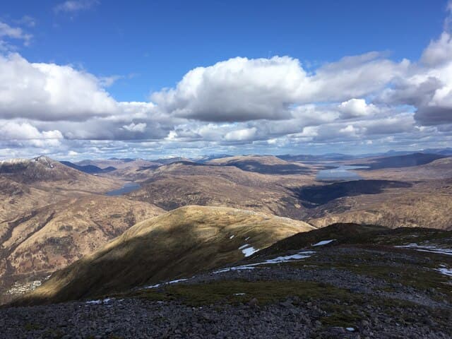
This Garbh Bheinn — "the rough hill", one of several so named in Scotland — sits south-east of Kinlochleven between Loch Eilde Mor and Loch Treig, in the quiet country that joins the Mamores to the Grey Corries. At 867m it is overshadowed by Munro neighbours on both sides but commands an outstanding panorama of the Mamore ridge and Ben Nevis to the north. The summit is a small rocky top reached by a long ridge of rough quartzite blocks that fully justify the hill's name.
Gaelic: “rough” · Pronunciation: garrav bheinn
Quick facts
- Height
- 867m/ 2844ft
- Prominence
- 332 m
- Distance
- 16 km
- Ascent
- 763 m
- Time
- 5–8 hrs
- Grid ref
- NN169600
- Parking
- NN187621
- Nearest city
- Fort William· 15km
- Dogs
- Dogs on lead required near livestockDog-friendly guide ↗
Height and prominence cross-checked against the Database of British and Irish Hills (CC BY).
No GPX track yet
Walked this route? Share your track to help other walkers.
Standard route
loch path 35% · open hillside 25% · quartzite ridge 30% · summit top 10%
The cleanest line starts from Kinlochleven, taking the path east past the Grey Mare's Tail waterfall and along the north shore of Loch Eilde Mor for around 6km. Where the loch path turns south at Luibeilt, climb north on rough grass and quartzite onto the broad south ridge of Garbh Bheinn and follow it pathless to the summit. Around 16km return with 763m of ascent. Strong parties extend over the Lairig Leacach to connect with Sgurr Innse and Cruach Innse.
Terrain
The Loch Eilde Mor track is good for the first 6km. Off it the ground is rough boulder-strewn moor — Garbh Bheinn earned its name. The summit ridge is broken quartzite blocks with no clear path; cairns are intermittent. Care needed in mist as the ridge has several minor humps and a single false summit. No exposure or scrambling proper.
In winter
A serious-feeling Corbett under snow because of the distance and the quartzite boulders becoming concealed and slippery. The north flank above Luibeilt holds drifts after westerlies. The Loch Eilde Mor track is a long cold walk in midwinter; the Aluminium Company railway is no longer accessible. Phone signal is intermittent at best.
This hill is in the Glen Coe SAIS forecast area. Check SAIS forecasts in winter (December–April).
Best time of year
Getting there
- Glasgow2h 12m
- Edinburgh3h 57m
OS maps: OS Landranger 41, OS Explorer 384
Mobile signal: Intermittent in Kinlochleven; none on the hill or along the loch
Current conditions
Daylight Today
- Sunrise
- 04:47
- Sunset
- 22:05
- Civil dawn
- 03:47
- Civil dusk
- 23:04
NOAA Solar Calculator · 13 July 2026
On a long-distance route
Garbh Bheinn sits within 5km of these named long-distance walks — useful for trail-pack rest days or section extensions.
Around Garbh Bheinn on the SCOT network
Getting there, basing yourself, and what to do off the hill.
Getting there: Fort William station
Ben Nevis, Mamores, Aonachs, Knoydart ferry connection
15km from the hill
tripscot.co.uk
On TripSCOTBase yourself in Fort William
Ben Nevis base, West Highland Line, gateway to Lochaber
15km from the hill
tripscot.co.uk
On TasteSCOTAfter the hill: Ben Nevis Distillery
Fort William — Lochaber distillery at the foot of the Ben; long-aged Japanese-owned classics
17km from the hill
tastescot.co.uk
Garbh Bheinn — common questions
- What difficulty is Garbh Bheinn?
- On the OutdoorSCOT scale, Garbh Bheinn comes in at 3/5 — moderately challenging. Expect roughly 16km and 763m of ascent on the usual route — 5-8 hours for most parties. Terrain: The Loch Eilde Mor track is good for the first 6km.
- How prominent is Garbh Bheinn?
- Garbh Bheinn has 332m of topographic prominence — the height of its summit above the highest col connecting it to higher ground.
- Where should I park to climb Garbh Bheinn?
- Standard parking is at NN187621. Check the parking grid reference on an OS map before travel; informal laybys can fill on summer weekends.
- When should I climb Garbh Bheinn?
- The standard good-weather months for Garbh Bheinn are May, June, July, August, September, October. Outside those months, expect winter conditions on the high ground — full mountain kit, navigation skills, and a check of the SAIS avalanche forecast for the relevant region.
- Can I bring my dog up Garbh Bheinn?
- On a lead only — the route crosses ground with livestock or nesting-bird interest.
- What's mobile reception like on Garbh Bheinn?
- Intermittent in Kinlochleven; none on the hill or along the loch
- Is Garbh Bheinn safe in winter?
- A serious-feeling Corbett under snow because of the distance and the quartzite boulders becoming concealed and slippery. The north flank above Luibeilt holds drifts after westerlies. The Loch Eilde Mor track is a long cold walk in midwinter; the Aluminium Company railway is no longer accessible. Phone signal is intermittent at best.
Get the OutdoorSCOT weekly
One email a week — new route, hill and bothy guides, seasonal conditions and the odd hard-won lesson. No spam, unsubscribe in one click.