Corbett · Glen Coe
Beinn a' Chrulaiste
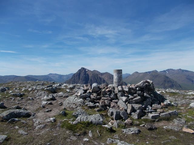
Beinn a' Chrulaiste is the broad heather hill rising directly opposite Buachaille Etive Mòr at the head of Glen Coe — and quite possibly the most photographed Corbett in Scotland, because every shot of the Buachaille reflected in Lochan na h-Achlaise is taken from somewhere on its flanks. The 857m summit gives the definitive front-row view of the Buachaille, with the Glen Coe Munros stretched out to the west and Rannoch Moor opening south. The walk is short and uncomplicated; the photographic opportunity at the right time of day is unmatched anywhere in mountain Scotland.
Quick facts
- Height
- 857m/ 2812ft
- Prominence
- 464 m
- Distance
- 8 km
- Ascent
- 590 m
- Time
- 2–4 hrs
- Grid ref
- NN246566
- Parking
- NN264555
- Nearest city
- Fort William· 22km
- Dogs
- Dogs on lead required near livestockDog-friendly guide ↗
Height and prominence cross-checked against the Database of British and Irish Hills (CC BY).
No GPX track yet
Walked this route? Share your track to help other walkers.
Standard route
moorland track 25% · heather hillside 40% · grassy upper slopes 25% · summit area 10%
Park at the Kingshouse Hotel car park or the layby on the A82 just east of it (NN264555). Cross the old road and follow a clear path north-east onto the south-west flank of Beinn a' Chrulaiste. The route climbs steadily through heather and grass onto the broad summit dome. Strong walkers extend by traversing east-north-east toward Stob na Cruaiche; most people retrace to enjoy the Buachaille view at a leisurely pace on descent. Allow 4–5 hours.
Terrain
A clear path most of the way — by Rannoch Moor standards exceptionally dry underfoot. Heather and grass throughout with occasional small rocky outcrops near the summit. The top is broad and rocky with a flat rock as cairn marker. No exposed ground anywhere on the standard route.
In winter
One of the better introductory winter Corbetts — gradient is friendly, route-finding obvious, and the descent route is hard to lose. Lee snow drifts on the north-east side of the summit dome. The walk works as a winter half-day for parties based at Kingshouse for serious objectives on the Buachaille; the Chrulaiste view of the surrounding peaks in winter light is exceptional.
This hill is in the Glen Coe SAIS forecast area. Check SAIS forecasts in winter (December–April).
Best time of year
Getting there
- Glasgow2h 4m
- Edinburgh3h 46m
OS maps: OS Landranger 41
Mobile signal: EE/Vodafone reasonable at the Kingshouse car park; weakens on the lower flanks; brief 4G on the summit with line-of-sight south over Rannoch Moor
Current conditions
Daylight Today
- Sunrise
- 04:53
- Sunset
- 21:59
- Civil dawn
- 03:55
- Civil dusk
- 22:56
NOAA Solar Calculator · 17 July 2026
Pair with
Curated multi-hill combinations from Beinn a' Chrulaiste.
Around Beinn a' Chrulaiste on the SCOT network
Getting there, basing yourself, and what to do off the hill.
Getting there: Corrour station
Highest mainline station; Loch Ossian, Ben Alder, Aonach Beag (Alder)
15km from the hill
tripscot.co.uk
On TripSCOTBase yourself in Fort William
Ben Nevis base, West Highland Line, gateway to Lochaber
22km from the hill
tripscot.co.uk
On TasteSCOTAfter the hill: Ben Nevis Distillery
Fort William — Lochaber distillery at the foot of the Ben; long-aged Japanese-owned classics
23km from the hill
tastescot.co.uk
Beinn a' Chrulaiste — common questions
- How hard is Beinn a' Chrulaiste?
- We grade Beinn a' Chrulaiste at 2/5, which puts it in moderate territory. The usual route is around 8km with 590m of climbing; allow 2-4 hours. Ground conditions: A clear path most of the way — by Rannoch Moor standards exceptionally dry underfoot.
- How much drop does Beinn a' Chrulaiste have?
- The drop is 464m: measured from the summit of Beinn a' Chrulaiste down to the saddle joining it to higher terrain.
- Where's the parking for Beinn a' Chrulaiste?
- Park at NN264555. Double-check the grid reference on an OS map first; informal laybys here fill early in high season.
- What's the best month to climb Beinn a' Chrulaiste?
- Aim for May, June, July, August, September, October on Beinn a' Chrulaiste. In the remaining months treat it as a winter hill — full kit, solid navigation, and a look at the relevant SAIS avalanche forecast before you go.
- Can dogs go up Beinn a' Chrulaiste?
- Dogs are fine on a lead. The route passes livestock or ground-nesting bird habitat, so keep them close throughout.
- Will I get phone signal on Beinn a' Chrulaiste?
- EE/Vodafone reasonable at the Kingshouse car park; weakens on the lower flanks; brief 4G on the summit with line-of-sight south over Rannoch Moor
- Is Beinn a' Chrulaiste safe in winter?
- One of the better introductory winter Corbetts — gradient is friendly, route-finding obvious, and the descent route is hard to lose. Lee snow drifts on the north-east side of the summit dome. The walk works as a winter half-day for parties based at Kingshouse for serious objectives on the Buachaille; the Chrulaiste view of the surrounding peaks in winter light is exceptional.
Get the OutdoorSCOT weekly
One email a week — new route, hill and bothy guides, seasonal conditions and the odd hard-won lesson. No spam, unsubscribe in one click.