Munro · Glen Coe & Lochaber
Buachaille Etive Mor - Stob Dearg
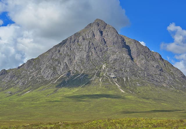
Stob Dearg (1021m) — "red peak" — is the iconic pyramid summit of the Buachaille Etive Mòr, "the great herdsman of Etive", probably the most photographed mountain in Scotland. The peak rises dramatically from the eastern end of Rannoch Moor as one of the great mountain images of the Highlands. Stob Dearg is the higher and more famous of two Munros on the Buachaille (with Stob na Bròige to the south-west); together they form the full ridge of one of Scotland's most celebrated mountains.
Gaelic: “big, pointed peak, red” · Pronunciation: buachaille etive more stob jerr-ak
Quick facts
- Height
- 1021.4m/ 3351ft
- Prominence
- 532 m
- Distance
- 17 km
- Ascent
- 899 m
- Time
- 5–8 hrs
- Grid ref
- NN222542
- Parking
- NN221563
- Nearest city
- Fort William· 23km
- Dogs
- Dogs on lead required near livestockDog-friendly guide ↗
Height and prominence cross-checked against the Database of British and Irish Hills (CC BY).
No GPX track yet
Walked this route? Share your track to help other walkers.
Standard route
Coire na Tulaich path 30% · Rocky corrie head 35% · Summit ridge 35%
Park at the Altnafeadh lay-by on the A82 at the foot of the Buachaille. Cross the River Coupall via the wire footbridge at Lagangarbh, then follow the well-built path up the deep Coire na Tulaich. The corrie headwall steepens to a serious scree gully that requires care in descent. From the high bealach turn east along the rocky ridge to Stob Dearg. Most parties continue south-west to Stob na Bròige for the second Munro. Around 11km with 1100m of ascent for the pair.
Terrain
The Lagangarbh footbridge is sound but the path beyond can be wet. The Coire na Tulaich path is well-built pitching for the lower section but the headwall is severely eroded loose scree — slippery in any conditions and particularly on descent. The summit ridge of Stob Dearg is broad rocky ground with the summit cairn perched at the edge of the great north-east face — the face that gives the Buachaille its iconic profile. The connecting ridge west to Stob na Bròige is broad and easy.
In winter
A major Glencoe winter mountaineering venue. The Coire na Tulaich headwall is the most-warned-about avalanche slope in Scotland — multiple fatal incidents have happened on the descent. Stob Dearg itself is a Grade III/IV climbing venue with iconic routes like Crowberry Gully and Curved Ridge. The A82 at Altnafeadh is gritted; Lagangarbh hut is SMC-owned (members only). SAIS Glencoe applies. Phone signal at the lay-by is reasonable; absent on the hill.
This hill is in the Glen Coe SAIS forecast area. Check SAIS forecasts in winter (December–April).
Best time of year
Getting there
- Glasgow2h 3m
- Edinburgh3h 47m
OS maps: OS Landranger 41
Mobile signal: Reasonable signal at the Altnafeadh car park on the A82. Signal thins beyond 700m on Stob Dearg. Line maps up before leaving Glencoe village.
Current conditions
Daylight Today
- Sunrise
- 05:03
- Sunset
- 21:49
- Civil dawn
- 04:09
- Civil dusk
- 22:44
NOAA Solar Calculator · 23 July 2026
Pair with
Curated multi-hill combinations from Buachaille Etive Mor - Stob Dearg.
Around Buachaille Etive Mor - Stob Dearg on the SCOT network
Getting there, basing yourself, and what to do off the hill.
Getting there: Bridge of Orchy station
Black Mount; Beinn Dorain, Beinn an Dothaidh, Beinn Achaladair, Beinn a Chreachain
16km from the hill
tripscot.co.uk
On TripSCOTBase yourself in Fort William
Ben Nevis base, West Highland Line, gateway to Lochaber
23km from the hill
tripscot.co.uk
On TasteSCOTAfter the hill: Ben Nevis Distillery
Fort William — Lochaber distillery at the foot of the Ben; long-aged Japanese-owned classics
24km from the hill
tastescot.co.uk
Buachaille Etive Mor - Stob Dearg — common questions
- How difficult is Buachaille Etive Mor - Stob Dearg?
- Buachaille Etive Mor - Stob Dearg carries a 4/5 (challenging) grade on the OutdoorSCOT scale. Count on about 17km, 899m of ascent and a 5-8 hour day on the standard route. Terrain: The Lagangarbh footbridge is sound but the path beyond can be wet.
- How prominent is Buachaille Etive Mor - Stob Dearg?
- Buachaille Etive Mor - Stob Dearg has 532m of topographic prominence — the height of its summit above the highest col connecting it to higher ground.
- Where should I park to climb Buachaille Etive Mor - Stob Dearg?
- Standard parking is at NN221563. Check the parking grid reference on an OS map before travel; informal laybys can fill on summer weekends.
- When should I climb Buachaille Etive Mor - Stob Dearg?
- The standard good-weather months for Buachaille Etive Mor - Stob Dearg are May, June, July, August, September, October. Outside those months, expect winter conditions on the high ground — full mountain kit, navigation skills, and a check of the SAIS avalanche forecast for the relevant region.
- Can I bring my dog up Buachaille Etive Mor - Stob Dearg?
- On a lead only — the route crosses ground with livestock or nesting-bird interest.
- What's mobile reception like on Buachaille Etive Mor - Stob Dearg?
- Reasonable signal at the Altnafeadh car park on the A82. Signal thins beyond 700m on Stob Dearg. Line maps up before leaving Glencoe village.
- Is Buachaille Etive Mor - Stob Dearg safe in winter?
- A major Glencoe winter mountaineering venue. The Coire na Tulaich headwall is the most-warned-about avalanche slope in Scotland — multiple fatal incidents have happened on the descent. Stob Dearg itself is a Grade III/IV climbing venue with iconic routes like Crowberry Gully and Curved Ridge. The A82 at Altnafeadh is gritted; Lagangarbh hut is SMC-owned (members only). SAIS Glencoe applies. Phone signal at the lay-by is reasonable; absent on the hill.
Get the OutdoorSCOT weekly
One email a week — new route, hill and bothy guides, seasonal conditions and the odd hard-won lesson. No spam, unsubscribe in one click.