Munro · Glen Coe & Lochaber
Creise
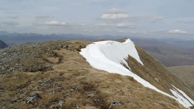
Creise is the 1100m Munro that forms the southern wall of the Glen Etive head, paired with Meall a' Bhuiridh across the broad high col. The mountain sits at the heart of the Black Mount range, with steep crag-broken faces dropping into Coireach a' Bha both ways and a long ridge running south over Clach Leathad and Stob a' Ghlais Choire. The summit is a small rock 3m from the main cairn, with views west across Rannoch Moor and north to Glen Coe.
Quick facts
- Height
- 1099.8m/ 3608ft
- Prominence
- 169 m
- Distance
- 18 km
- Ascent
- 968 m
- Time
- 6–9 hrs
- Grid ref
- NN238506
- Parking
- NN267525
- Nearest city
- Fort William· 27km
- Dogs
- Dogs on lead required near livestockDog-friendly guide ↗
Height and prominence cross-checked against the Database of British and Irish Hills (CC BY).
No GPX track yet
Walked this route? Share your track to help other walkers.
Standard route
Ski area path / open hillside 35% · Broad ridge 40% · Summit area 25%
The popular line links Creise with Meall a' Bhuiridh via the high connecting col, starting from the Glencoe Mountain ski area. Most parties traverse west over Meall a' Bhuiridh to Creise, then return the same way or descend south via the long Aonach Mor ridge to Victoria Bridge for a longer linear day. Around 18km with 968m of cumulative ascent for the pair.
Terrain
The Glencoe Mountain ski-area access road is firm tarmac. Above the resort the going turns to grass and broken rock; the connecting ridge to Meall a' Bhuiridh has one short rocky step that needs a hand on rock in places. The Creise summit is a rocky platform with the cairn unmistakable. The west drop into Coireach a' Bha is steep and edge-undercut.
In winter
A major Glen Coe winter venue. The east and west faces hold steep snow and cornicing throughout the season. The east-facing slopes carry significant avalanche hazard after a westerly loading event. The A82 stays gritted; SAIS Glencoe is the relevant report. Ski-area infrastructure can be useful for early-season recces but does not run as a lift for walkers.
This hill is in the Glen Coe SAIS forecast area. Check SAIS forecasts in winter (December–April).
Best time of year
Getting there
- Glasgow2h 58m
- Edinburgh3h 42m
OS maps: OS Landranger 41
Mobile signal: Good signal at the Glencoe Mountain ski area car park. Signal drops above 800m.
Current conditions
Daylight Today
- Sunrise
- 05:03
- Sunset
- 21:49
- Civil dawn
- 04:09
- Civil dusk
- 22:43
NOAA Solar Calculator · 23 July 2026
Pair with
Curated multi-hill combinations from Creise.
Around Creise on the SCOT network
Getting there, basing yourself, and what to do off the hill.
Getting there: Bridge of Orchy station
Black Mount; Beinn Dorain, Beinn an Dothaidh, Beinn Achaladair, Beinn a Chreachain
12km from the hill
tripscot.co.uk
On TripSCOTBase yourself in Fort William
Ben Nevis base, West Highland Line, gateway to Lochaber
27km from the hill
tripscot.co.uk
On TasteSCOTAfter the hill: Ben Nevis Distillery
Fort William — Lochaber distillery at the foot of the Ben; long-aged Japanese-owned classics
28km from the hill
tastescot.co.uk
Creise — common questions
- How hard is Creise?
- We grade Creise at 4/5, which puts it in challenging territory. The usual route is around 18km with 968m of climbing; allow 6-9 hours. Underfoot: The Glencoe Mountain ski-area access road is firm tarmac.
- What is Creise's prominence?
- 169m of prominence. That's the vertical drop from the summit to the col that links Creise to the next higher ground.
- Where do I park for Creise?
- Most walkers start from NN267525. Verify the grid reference on an OS map before you set off — space is tight on busy summer weekends.
- When is the best time to climb Creise?
- May, June, July, August, September, October give the most reliable conditions on Creise. Beyond that window the high ground turns wintry: carry full mountain kit, be confident navigating, and check the SAIS avalanche forecast for the area.
- Is Creise dog-friendly?
- Yes, but dogs must be kept on a lead — there is livestock or ground-nesting bird interest on the route.
- Is there mobile signal on Creise?
- Good signal at the Glencoe Mountain ski area car park. Signal drops above 800m.
- Is Creise safe in winter?
- A major Glen Coe winter venue. The east and west faces hold steep snow and cornicing throughout the season. The east-facing slopes carry significant avalanche hazard after a westerly loading event. The A82 stays gritted; SAIS Glencoe is the relevant report. Ski-area infrastructure can be useful for early-season recces but does not run as a lift for walkers.
Get the OutdoorSCOT weekly
One email a week — new route, hill and bothy guides, seasonal conditions and the odd hard-won lesson. No spam, unsubscribe in one click.