Graham · Glen Coe & Lochaber
Beinn Suidhe
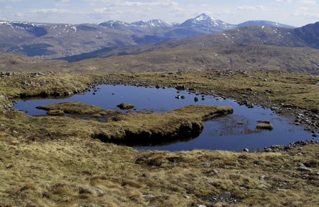
Beinn Suidhe (676m) — the seat hill — sits south of Loch Tulla in the NN24 square, a satellite of the bigger Bridge of Orchy peaks. Its 280m of re-ascent gives it a clear individuality and the cairn looks across Loch Dochard to Ben Starav and the wild upper reach of Glen Kinglass. A natural pairing with Beinn nan Aighenan or as a stand-alone afternoon outing.
Quick facts
- Height
- 676.3m/ 2219ft
- Prominence
- 280 m
- Distance
- 13 km
- Ascent
- 554 m
- Time
- 3–6 hrs
- Grid ref
- NN211400
- Parking
- NN194374
- Nearest city
- Fort William· 36km
- Dogs
- Dogs on lead required near livestockDog-friendly guide ↗
Height and prominence cross-checked against the Database of British and Irish Hills (CC BY).
No GPX track yet
Walked this route? Share your track to help other walkers.
Standard route
heather and bracken 55% · grass slopes 30% · rocky summit 15%
Park at Victoria Bridge near Bridge of Orchy and follow the West Highland Way south for a kilometre. Branch off west along the rough track toward Clashgour, then climb the broad north-east shoulder of Beinn Suidhe on heather and short grass. The summit cairn perches on a rock plinth three metres beyond a smaller cairn — be sure to touch the right one.
Terrain
West Highland Way for the initial walk-in, then estate track and a heather pull onto the broad shoulder. Above 500m the going changes to short grass and patches of slabby schist that grip well. The summit area is small and rocky.
In winter
Bridge of Orchy gets serious west-coast snow and Beinn Suidhe holds a deep cover on its north and east flanks. The schist slabs near the cairn ice up quickly. SAIS Glencoe forecasts cover the broader area — the connecting ridge to Beinn nan Aighenan can produce sizeable cornices on its south side.
This hill is in the Glen Coe SAIS forecast area. Check SAIS forecasts in winter (December–April).
Best time of year
Getting there
- Glasgow2h 47m
- Edinburgh3h 38m
OS maps: OS Landranger 50
Mobile signal: Moderate. EE connects on higher ground; Vodafone intermittent.
Current conditions
Daylight Today
- Sunrise
- 04:48
- Sunset
- 22:03
- Civil dawn
- 03:49
- Civil dusk
- 23:02
NOAA Solar Calculator · 13 July 2026
Around Beinn Suidhe on the SCOT network
Getting there, basing yourself, and what to do off the hill.
Getting there: Bridge of Orchy station
Black Mount; Beinn Dorain, Beinn an Dothaidh, Beinn Achaladair, Beinn a Chreachain
9km from the hill
tripscot.co.uk
On TripSCOTBase yourself in Fort William
Ben Nevis base, West Highland Line, gateway to Lochaber
36km from the hill
tripscot.co.uk
Beinn Suidhe — common questions
- Is Beinn Suidhe a hard climb?
- Beinn Suidhe is rated 3/5 (moderately challenging) on the OutdoorSCOT scale. The standard route covers about 13km with 554m of ascent and takes most walkers 3-6 hours. Ground conditions: West Highland Way for the initial walk-in, then estate track and a heather pull onto the broad shoulder.
- How much drop does Beinn Suidhe have?
- The drop is 280m: measured from the summit of Beinn Suidhe down to the saddle joining it to higher terrain.
- Where's the parking for Beinn Suidhe?
- Park at NN194374. Double-check the grid reference on an OS map first; informal laybys here fill early in high season.
- What's the best month to climb Beinn Suidhe?
- Aim for March, April, May, June, July, August, September, October, November on Beinn Suidhe. In the remaining months treat it as a winter hill — full kit, solid navigation, and a look at the relevant SAIS avalanche forecast before you go.
- Can dogs go up Beinn Suidhe?
- Dogs are fine on a lead. The route passes livestock or ground-nesting bird habitat, so keep them close throughout.
- Will I get phone signal on Beinn Suidhe?
- Moderate. EE connects on higher ground; Vodafone intermittent.
- Is Beinn Suidhe safe in winter?
- Bridge of Orchy gets serious west-coast snow and Beinn Suidhe holds a deep cover on its north and east flanks. The schist slabs near the cairn ice up quickly. SAIS Glencoe forecasts cover the broader area — the connecting ridge to Beinn nan Aighenan can produce sizeable cornices on its south side.
Get the OutdoorSCOT weekly
One email a week — new route, hill and bothy guides, seasonal conditions and the odd hard-won lesson. No spam, unsubscribe in one click.