Graham · Glen Coe & Lochaber
Meall Garbh
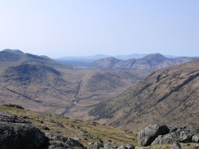
Meall Garbh (700m) — the rough lump — is a heathery dome south of Loch Lyon in the NN16 square, hemmed between the Lyon dam and the Munro mass of Stuchd an Lochain. Although modest, its position gives a fine outlook across the Glen Lyon hills and along the chain of reservoirs that drain east to Loch Tay.
Gaelic: “rounded hill, rough” · Pronunciation: myowl garrav
Quick facts
- Height
- 700.3m/ 2298ft
- Prominence
- 259 m
- Distance
- 13 km
- Ascent
- 574 m
- Time
- 3–6 hrs
- Grid ref
- NN167367
- Parking
- NN171361
- Nearest city
- Oban· 31km
- Dogs
- Dogs on lead required near livestockDog-friendly guide ↗
Height and prominence cross-checked against the Database of British and Irish Hills (CC BY).
No GPX track yet
Walked this route? Share your track to help other walkers.
Standard route
heather moorland 55% · grass slopes 30% · rocky summit 15%
Start from the road end at Loch Lyon dam. Follow the metalled service road around the loch's south shore for around 2km then leave it for a deer-fence corner, climbing south on tussocks to gain the broad east ridge. A faint quad trail traces the crest to the cairn.
Terrain
Tarmac, then quad tracks, then knee-deep tussock and bog. The east ridge has occasional schist outcrops but stays gentle. The summit dome is broad cropped grass with no defining feature beyond its small cairn.
In winter
South of the main Breadalbane crest, this corner of Glen Lyon catches drier, more continental snow than peaks to the west. Drifting can fill the col between Meall Garbh and Beinn nan Eachan to surprising depth. SAIS Southern Cairngorms forecasts apply once snow lies past Christmas.
This hill is in the Glen Coe SAIS forecast area. Check SAIS forecasts in winter (December–April).
Best time of year
Getting there
- Glasgow2h 46m
- Edinburgh3h 40m
OS maps: OS Landranger 50
Mobile signal: Moderate. EE connects intermittently on summit; stronger on south-facing slopes toward Loch Tay.
Current conditions
Daylight Today
- Sunrise
- 04:54
- Sunset
- 21:58
- Civil dawn
- 03:57
- Civil dusk
- 22:55
NOAA Solar Calculator · 17 July 2026
Around Meall Garbh on the SCOT network
Getting there, basing yourself, and what to do off the hill.
Meall Garbh — common questions
- What difficulty is Meall Garbh?
- On the OutdoorSCOT scale, Meall Garbh comes in at 3/5 — moderately challenging. Expect roughly 13km and 574m of ascent on the usual route — 3-6 hours for most parties. Underfoot: Tarmac, then quad tracks, then knee-deep tussock and bog.
- What is Meall Garbh's prominence?
- 259m of prominence. That's the vertical drop from the summit to the col that links Meall Garbh to the next higher ground.
- Where do I park for Meall Garbh?
- Most walkers start from NN171361. Verify the grid reference on an OS map before you set off — space is tight on busy summer weekends.
- When is the best time to climb Meall Garbh?
- April, May, June, July, August, September, October give the most reliable conditions on Meall Garbh. Beyond that window the high ground turns wintry: carry full mountain kit, be confident navigating, and check the SAIS avalanche forecast for the area.
- Is Meall Garbh dog-friendly?
- Yes, but dogs must be kept on a lead — there is livestock or ground-nesting bird interest on the route.
- Is there mobile signal on Meall Garbh?
- Moderate. EE connects intermittently on summit; stronger on south-facing slopes toward Loch Tay.
- Is Meall Garbh safe in winter?
- South of the main Breadalbane crest, this corner of Glen Lyon catches drier, more continental snow than peaks to the west. Drifting can fill the col between Meall Garbh and Beinn nan Eachan to surprising depth. SAIS Southern Cairngorms forecasts apply once snow lies past Christmas.
Get the OutdoorSCOT weekly
One email a week — new route, hill and bothy guides, seasonal conditions and the odd hard-won lesson. No spam, unsubscribe in one click.