Graham · Glen Coe & Lochaber
Meall Tairbh
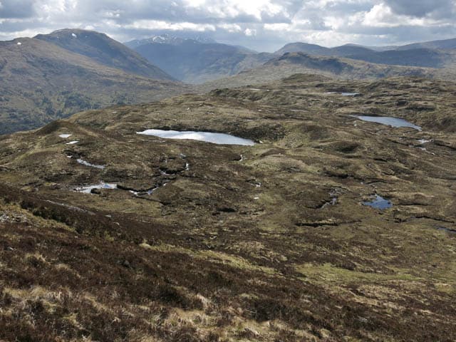
Meall Tairbh (664m) — the bull's hill — sits above Bridge of Orchy in the NN23 square, an outlier of the Beinn Dorain range looking south over Loch Tulla to the Black Mount. The cairn marks the highest point of a broad heathery shoulder that catches the morning sun before the larger peaks behind. A short half-day from the A82.
Quick facts
- Height
- 664.4m/ 2180ft
- Prominence
- 256 m
- Distance
- 13 km
- Ascent
- 544 m
- Time
- 3–6 hrs
- Grid ref
- NN250375
- Parking
- NN208373
- Nearest city
- Fort William· 39km
- Dogs
- Dogs on lead required near livestockDog-friendly guide ↗
Height and prominence cross-checked against the Database of British and Irish Hills (CC BY).
No GPX track yet
Walked this route? Share your track to help other walkers.
Standard route
heather moorland 65% · grass slopes 25% · rocky summit 10%
Park at the Bridge of Orchy hotel and follow the West Highland Way north for a kilometre. Branch off east onto open hillside near the railway and climb the broad south-west spur on quad rut and heather. The summit cairn appears on the flat top after a steady but uneventful pull — the descent reverses the line or extends north to the col with Beinn Dorain for a longer round.
Terrain
West Highland Way at the start, then quad ruts through tussock and heather on the south-west spur. The summit dome is firm short grass with a small cairn at its highest point. Easy walking once on the open hill.
In winter
Bridge of Orchy gets serious west-coast snow and Meall Tairbh holds drifts on its eastern flank toward Beinn Dorain. The col with the Munro behind can build dangerous wind slab. SAIS Glencoe forecasts cover the area and should be checked even for a short outing here.
This hill is in the Glen Coe SAIS forecast area. Check SAIS forecasts in winter (December–April).
Best time of year
Getting there
- Glasgow2h 54m
- Edinburgh3h 32m
OS maps: OS Landranger 50
Mobile signal: Poor. Remote Loch Lochy/Great Glen area; limited coverage.
Current conditions
Daylight Today
- Sunrise
- 04:48
- Sunset
- 22:03
- Civil dawn
- 03:49
- Civil dusk
- 23:01
NOAA Solar Calculator · 13 July 2026
Around Meall Tairbh on the SCOT network
Getting there, basing yourself, and what to do off the hill.
Getting there: Bridge of Orchy station
Black Mount; Beinn Dorain, Beinn an Dothaidh, Beinn Achaladair, Beinn a Chreachain
5km from the hill
tripscot.co.uk
On TripSCOTBase yourself in Fort William
Ben Nevis base, West Highland Line, gateway to Lochaber
39km from the hill
tripscot.co.uk
Meall Tairbh — common questions
- How difficult is Meall Tairbh?
- Meall Tairbh carries a 3/5 (moderately challenging) grade on the OutdoorSCOT scale. Count on about 13km, 544m of ascent and a 3-6 hour day on the standard route. Underfoot: West Highland Way at the start, then quad ruts through tussock and heather on the south-west spur.
- What is Meall Tairbh's prominence?
- 256m of prominence. That's the vertical drop from the summit to the col that links Meall Tairbh to the next higher ground.
- Where do I park for Meall Tairbh?
- Most walkers start from NN208373. Verify the grid reference on an OS map before you set off — space is tight on busy summer weekends.
- When is the best time to climb Meall Tairbh?
- March, April, May, June, July, August, September, October, November give the most reliable conditions on Meall Tairbh. Beyond that window the high ground turns wintry: carry full mountain kit, be confident navigating, and check the SAIS avalanche forecast for the area.
- Is Meall Tairbh dog-friendly?
- Yes, but dogs must be kept on a lead — there is livestock or ground-nesting bird interest on the route.
- Is there mobile signal on Meall Tairbh?
- Poor. Remote Loch Lochy/Great Glen area; limited coverage.
- Is Meall Tairbh safe in winter?
- Bridge of Orchy gets serious west-coast snow and Meall Tairbh holds drifts on its eastern flank toward Beinn Dorain. The col with the Munro behind can build dangerous wind slab. SAIS Glencoe forecasts cover the area and should be checked even for a short outing here.
Get the OutdoorSCOT weekly
One email a week — new route, hill and bothy guides, seasonal conditions and the odd hard-won lesson. No spam, unsubscribe in one click.