Corbett · Glen Orchy
Beinn Bhreac-liath
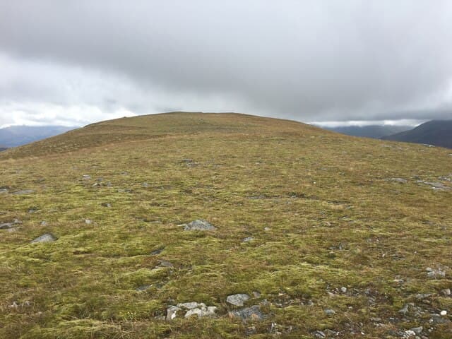
Beinn Bhreac-liath — 'the speckled grey hill' — is the rounded Corbett rising directly above the West Highland Railway and the A82 north of Tyndrum, sitting in the bowl of hills between Beinn Odhar (the well-known Tyndrum cone) and Beinn a' Chuirn. At 802m it gives one of the easier short Corbett ascents in central Scotland, with a clear path most of the way and a broad summit looking across to Ben Lui and the Crianlarich Munros.
Gaelic: “mountain, grey” · Pronunciation: bine bhreac lee-ah
Quick facts
- Height
- 802m/ 2631ft
- Prominence
- 215 m
- Distance
- 11 km
- Ascent
- 620 m
- Time
- 3–5 hrs
- Grid ref
- NN302339
- Parking
- NN329308
- Nearest city
- Oban· 44km
- Dogs
- Dogs on lead required near livestockDog-friendly guide ↗
Height and prominence cross-checked against the Database of British and Irish Hills (CC BY).
No GPX track yet
Walked this route? Share your track to help other walkers.
Standard route
glen track 25% · heather hillside 45% · grassy upper ridge 20% · summit area 10%
Use the same Tyndrum upper-village layby on the A82 that serves Beinn Odhar (NN329308). From the village, walk north over the railway level crossing and pick up a stalkers' track that heads east toward the hill. The track lifts onto open ground and onto Beinn Bhreac-liath's broad south flank; a steady climb leads to the summit cairn. Many parties combine it with Beinn Odhar for a tidy Tyndrum two-summit round. About 4.5–5 hours for Beinn Bhreac-liath on its own.
Terrain
A reasonable estate track covers the lower kilometre. Beyond it, a mix of grass, heather and the occasional small rock step underfoot. The top is broad and stony with a substantial cairn. Wet on the lower flanks; firmer above 600m.
In winter
A friendly winter Corbett — the broad slopes give no avalanche concerns and the route is hard to lose. Snow lies well from January through March. Tyndrum stays reliably accessible by car and the West Highland Line runs through the day. Cold easterly winds can be ferocious on the summit; pair with Beinn Odhar for the natural double winter round.
This hill is in the Glen Coe SAIS forecast area. Check SAIS forecasts in winter (December–April).
Best time of year
Getting there
- Glasgow2h 46m
- Edinburgh2h 24m
OS maps: OS Landranger 50
Mobile signal: Poor signal in upper Glen Orchy area
Current conditions
Daylight Today
- Sunrise
- 04:54
- Sunset
- 21:57
- Civil dawn
- 03:57
- Civil dusk
- 22:54
NOAA Solar Calculator · 17 July 2026
Around Beinn Bhreac-liath on the SCOT network
Getting there, basing yourself, and what to do off the hill.
Beinn Bhreac-liath — common questions
- Is Beinn Bhreac-liath a hard climb?
- Beinn Bhreac-liath is rated 2/5 (moderate) on the OutdoorSCOT scale. The standard route covers about 11km with 620m of ascent and takes most walkers 3-5 hours. Ground conditions: A reasonable estate track covers the lower kilometre.
- How much drop does Beinn Bhreac-liath have?
- The drop is 215m: measured from the summit of Beinn Bhreac-liath down to the saddle joining it to higher terrain.
- Where's the parking for Beinn Bhreac-liath?
- Park at NN329308. Double-check the grid reference on an OS map first; informal laybys here fill early in high season.
- What's the best month to climb Beinn Bhreac-liath?
- Aim for April, May, June, July, August, September, October on Beinn Bhreac-liath. In the remaining months treat it as a winter hill — full kit, solid navigation, and a look at the relevant SAIS avalanche forecast before you go.
- Can dogs go up Beinn Bhreac-liath?
- Dogs are fine on a lead. The route passes livestock or ground-nesting bird habitat, so keep them close throughout.
- Will I get phone signal on Beinn Bhreac-liath?
- Poor signal in upper Glen Orchy area
- Is Beinn Bhreac-liath safe in winter?
- A friendly winter Corbett — the broad slopes give no avalanche concerns and the route is hard to lose. Snow lies well from January through March. Tyndrum stays reliably accessible by car and the West Highland Line runs through the day. Cold easterly winds can be ferocious on the summit; pair with Beinn Odhar for the natural double winter round.
Get the OutdoorSCOT weekly
One email a week — new route, hill and bothy guides, seasonal conditions and the odd hard-won lesson. No spam, unsubscribe in one click.