Corbett · Fife & Perthshire
Beinn a' Chaisteil
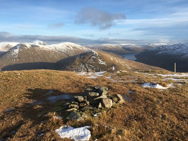
Beinn a' Chaisteil — "the castle hill" — is the southernmost of the Auch group, a rounded grassy Corbett rising directly above the A82 north of Tyndrum. Its 886m summit forms part of a long line of hills walked by anyone heading along the West Highland Way past Auch farm. The hill is named for the small rocky castle-like prominence on its east shoulder. The view south over Strath Fillan to Ben Lui and east into Glen Coe gives one of the best mountain summary panoramas in the southern Highlands.
Gaelic: “mountain, of the, castle” · Pronunciation: bine uh chash-til
Quick facts
- Height
- 886m/ 2907ft
- Prominence
- 467 m
- Distance
- 16 km
- Ascent
- 780 m
- Time
- 5–8 hrs
- Grid ref
- NN347364
- Parking
- NN317355
- Nearest city
- Fort William· 45km
- Dogs
- Dogs on lead required near livestockDog-friendly guide ↗
Height and prominence cross-checked against the Database of British and Irish Hills (CC BY).
No GPX track yet
Walked this route? Share your track to help other walkers.
Standard route
estate track 25% · WHW path 15% · broad grass 50% · summit dome 10%
Start from the lay-by on the A82 just south of Auch viaduct and walk in along the access track to Auch farm. From there, cross the river (footbridge) and follow the West Highland Way path north for a short distance before peeling off west onto the open south slopes of Beinn a' Chaisteil. Climb the broad south-east ridge to the summit. Around 16km with 780m of ascent if extended over the adjacent Corbett Beinn Odhar — most parties combine the two.
Terrain
Approach tracks at Auch are firm. The lower hillside is rough tussocky grass with scattered crag bands — the "castle" itself is a small rocky outcrop on the east flank, easily skirted. The summit ridge is broad and grassy with a gentle gradient. No scrambling required and no exposure. The Auch viaduct path can be busy with West Highland Way walkers in summer.
In winter
A friendlier winter hill than its bigger neighbours — the gentle slopes hold snow well but rarely build cornices. Avalanche risk is minimal on the broad south face. The main consideration is wind exposure and the long return walk if conditions deteriorate. The A82 lay-by is usually clear in winter; check road conditions over Rannoch Moor for the return.
Best time of year
Getting there
- Glasgow2h 47m
- Edinburgh2h 21m
OS maps: OS Landranger 50, OS Explorer 377
Mobile signal: Reasonable signal on the A82 corridor; usable on the summit
Current conditions
Daylight Today
- Sunrise
- 04:47
- Sunset
- 22:02
- Civil dawn
- 03:48
- Civil dusk
- 23:01
NOAA Solar Calculator · 13 July 2026
Pair with
Curated multi-hill combinations from Beinn a' Chaisteil.
Around Beinn a' Chaisteil on the SCOT network
Getting there, basing yourself, and what to do off the hill.
Beinn a' Chaisteil — common questions
- Is Beinn a' Chaisteil a hard climb?
- Beinn a' Chaisteil is rated 3/5 (moderately challenging) on the OutdoorSCOT scale. The standard route covers about 16km with 780m of ascent and takes most walkers 5-8 hours. Terrain: Approach tracks at Auch are firm.
- How prominent is Beinn a' Chaisteil?
- Beinn a' Chaisteil has 467m of topographic prominence — the height of its summit above the highest col connecting it to higher ground.
- Where should I park to climb Beinn a' Chaisteil?
- Standard parking is at NN317355. Check the parking grid reference on an OS map before travel; informal laybys can fill on summer weekends.
- When should I climb Beinn a' Chaisteil?
- The standard good-weather months for Beinn a' Chaisteil are May, June, July, August, September, October. Outside those months, expect winter conditions on the high ground — full mountain kit, navigation skills, and a check of the SAIS avalanche forecast for the relevant region.
- Can I bring my dog up Beinn a' Chaisteil?
- On a lead only — the route crosses ground with livestock or nesting-bird interest.
- What's mobile reception like on Beinn a' Chaisteil?
- Reasonable signal on the A82 corridor; usable on the summit
- Is Beinn a' Chaisteil safe in winter?
- A friendlier winter hill than its bigger neighbours — the gentle slopes hold snow well but rarely build cornices. Avalanche risk is minimal on the broad south face. The main consideration is wind exposure and the long return walk if conditions deteriorate. The A82 lay-by is usually clear in winter; check road conditions over Rannoch Moor for the return.
Get the OutdoorSCOT weekly
One email a week — new route, hill and bothy guides, seasonal conditions and the odd hard-won lesson. No spam, unsubscribe in one click.