Corbett · Fife & Perthshire
Beinn nam Fuaran
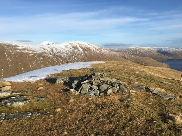
Beinn nam Fuaran — "hill of the springs" — is the fourth and most northerly of the Auch group of Corbetts, sitting above the head of Auch Gleann between Beinn a' Chaisteil and the Munro Beinn Mhanach. At 806m the summit is a small cairn on a broad grassy dome, with the view stretching west to Ben Dorain and north into Auch Gleann's upper reaches. The hill is the quietest of the Auch four, often included only on the longest combination days.
Quick facts
- Height
- 806m/ 2644ft
- Prominence
- 260 m
- Distance
- 15 km
- Ascent
- 709 m
- Time
- 4–7 hrs
- Grid ref
- NN361381
- Parking
- NN317355
- Nearest city
- Fort William· 44km
- Dogs
- Dogs on lead required near livestockDog-friendly guide ↗
Height and prominence cross-checked against the Database of British and Irish Hills (CC BY).
No GPX track yet
Walked this route? Share your track to help other walkers.
Standard route
estate track 35% · open grass 35% · broad ridge 20% · summit dome 10%
Like its Auch neighbours, the hill is reached from Auch on the A82. Walk in past Auch farm and along the West Highland Way before climbing into Auch Gleann via the estate track. Where the glen opens out, push pathless east up grass slopes to gain the broad south ridge of Beinn nam Fuaran. An undemanding pull up the ridge ends at the cairn. About 15km out-and-back with 709m of climbing for the hill alone. Most parties include it on a long Auch round.
Terrain
The Auch farm track and West Highland Way path give a firm approach. The Auch Gleann estate track is rougher but bike-able. Off the track the ground is tussocky grass with patches of bog; the broad ridge above is short grass. No exposure or rocky steps. The summit dome is featureless and demands compass work in mist; the cairn is easy to miss.
In winter
A reliable winter Corbett — gentle gradients, no avalanche risk, no cornicing on the broad ridge. The A82 corridor and Auch farm access are gritted. The Auch Gleann track ices over in cold snaps; bikes become unrideable. Daylight is short but the close approach keeps the day manageable.
Best time of year
Getting there
- Glasgow2h 49m
- Edinburgh2h 21m
OS maps: OS Landranger 50
Mobile signal: Reasonable signal on the A82 corridor; intermittent in Auch Gleann
Current conditions
Daylight Today
- Sunrise
- 04:47
- Sunset
- 22:02
- Civil dawn
- 03:48
- Civil dusk
- 23:01
NOAA Solar Calculator · 13 July 2026
Around Beinn nam Fuaran on the SCOT network
Getting there, basing yourself, and what to do off the hill.
Beinn nam Fuaran — common questions
- Is Beinn nam Fuaran a hard climb?
- Beinn nam Fuaran is rated 3/5 (moderately challenging) on the OutdoorSCOT scale. The standard route covers about 15km with 709m of ascent and takes most walkers 4-7 hours. Ground conditions: The Auch farm track and West Highland Way path give a firm approach.
- How much drop does Beinn nam Fuaran have?
- The drop is 260m: measured from the summit of Beinn nam Fuaran down to the saddle joining it to higher terrain.
- Where's the parking for Beinn nam Fuaran?
- Park at NN317355. Double-check the grid reference on an OS map first; informal laybys here fill early in high season.
- What's the best month to climb Beinn nam Fuaran?
- Aim for April, May, June, July, August, September, October on Beinn nam Fuaran. In the remaining months treat it as a winter hill — full kit, solid navigation, and a look at the relevant SAIS avalanche forecast before you go.
- Can dogs go up Beinn nam Fuaran?
- Dogs are fine on a lead. The route passes livestock or ground-nesting bird habitat, so keep them close throughout.
- Will I get phone signal on Beinn nam Fuaran?
- Reasonable signal on the A82 corridor; intermittent in Auch Gleann
- Is Beinn nam Fuaran safe in winter?
- A reliable winter Corbett — gentle gradients, no avalanche risk, no cornicing on the broad ridge. The A82 corridor and Auch farm access are gritted. The Auch Gleann track ices over in cold snaps; bikes become unrideable. Daylight is short but the close approach keeps the day manageable.
Get the OutdoorSCOT weekly
One email a week — new route, hill and bothy guides, seasonal conditions and the odd hard-won lesson. No spam, unsubscribe in one click.