Corbett · Fife & Perthshire
Beinn Chaorach
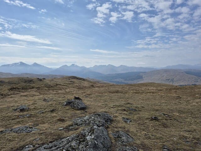
Beinn Chaorach — "hill of the sheep" — is the third hill of the Auch group, sitting north of the A82 between Bridge of Orchy and Tyndrum and continuing the long line of Corbetts that runs from Beinn a' Chaisteil through Cam Chreag. At 818m it is a hill of broad grass slopes and small rocky steps, the summit a flat embedded slab on a wide ridge. The view east across upper Glen Lyon and west to Ben Dorain gives it a central-Highland feel that belies its position close to the busy A82 corridor.
Quick facts
- Height
- 818m/ 2684ft
- Prominence
- 180 m
- Distance
- 15 km
- Ascent
- 720 m
- Time
- 4–7 hrs
- Grid ref
- NN358328
- Parking
- NN317355
- Nearest city
- Fort William· 48km
- Dogs
- Dogs on lead required near livestockDog-friendly guide ↗
Height and prominence cross-checked against the Database of British and Irish Hills (CC BY).
No GPX track yet
Walked this route? Share your track to help other walkers.
Standard route
estate track 25% · WHW path 10% · tussocky grass 45% · summit slab 20%
Park at Auch on the A82 below the viaduct and walk in past Auch farm on the estate track. After roughly 4km of track and a short stretch of West Highland Way path, climb open grass slopes north onto the broad south-east ridge of Beinn Chaorach and follow it to the summit slab. Around 15km return with 720m of ascent if combined with the neighbouring Auch Corbetts. Often tackled as a three-Corbett day with Cam Chreag and Beinn a' Chaisteil from the same start.
Terrain
The Auch farm track is firm and well-graded. Off the track the hillside is tussocky grass with patches of crag — the going is slow but never technical. The broad summit ridge has a series of small rocky steps that can be skirted on the south side. The embedded slab at the highest point is unmistakable. No exposure or scrambling.
In winter
A gentle winter day on the Auch ridge — easy gradients, no avalanche-prone slopes, and no cornicing on the broad crest. The A82 corridor is gritted and reliable in any conditions. The Auch farm track ices in cold snaps; the open hill above gives no shelter from prevailing winds. Daylight is limited in deep midwinter but the short approach keeps a single hill within reach.
Best time of year
Getting there
- Glasgow2h 42m
- Edinburgh2h 17m
OS maps: OS Landranger 50
Mobile signal: Reasonable signal on the A82 corridor; usable on the summit
Current conditions
Daylight Today
- Sunrise
- 04:47
- Sunset
- 22:02
- Civil dawn
- 03:49
- Civil dusk
- 23:00
NOAA Solar Calculator · 13 July 2026
Pair with
Curated multi-hill combinations from Beinn Chaorach.
Around Beinn Chaorach on the SCOT network
Getting there, basing yourself, and what to do off the hill.
Beinn Chaorach — common questions
- What difficulty is Beinn Chaorach?
- On the OutdoorSCOT scale, Beinn Chaorach comes in at 3/5 — moderately challenging. Expect roughly 15km and 720m of ascent on the usual route — 4-7 hours for most parties. Underfoot: The Auch farm track is firm and well-graded.
- What is Beinn Chaorach's prominence?
- 180m of prominence. That's the vertical drop from the summit to the col that links Beinn Chaorach to the next higher ground.
- Where do I park for Beinn Chaorach?
- Most walkers start from NN317355. Verify the grid reference on an OS map before you set off — space is tight on busy summer weekends.
- When is the best time to climb Beinn Chaorach?
- April, May, June, July, August, September, October give the most reliable conditions on Beinn Chaorach. Beyond that window the high ground turns wintry: carry full mountain kit, be confident navigating, and check the SAIS avalanche forecast for the area.
- Is Beinn Chaorach dog-friendly?
- Yes, but dogs must be kept on a lead — there is livestock or ground-nesting bird interest on the route.
- Is there mobile signal on Beinn Chaorach?
- Reasonable signal on the A82 corridor; usable on the summit
- Is Beinn Chaorach safe in winter?
- A gentle winter day on the Auch ridge — easy gradients, no avalanche-prone slopes, and no cornicing on the broad crest. The A82 corridor is gritted and reliable in any conditions. The Auch farm track ices in cold snaps; the open hill above gives no shelter from prevailing winds. Daylight is limited in deep midwinter but the short approach keeps a single hill within reach.
Get the OutdoorSCOT weekly
One email a week — new route, hill and bothy guides, seasonal conditions and the odd hard-won lesson. No spam, unsubscribe in one click.