Munro · Fife & Perthshire
Beinn Challuim (Ben Challum)
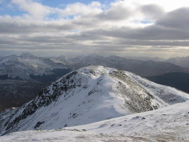
Beinn Challuim (1024m) — anglicised as Ben Challum or "Malcolm's hill" — is the long whaleback Munro that rises north of Strath Fillan, visible to all walkers on the West Highland Way between Tyndrum and Crianlarich. The hill has a deceptive twin-topped summit: the South Top at the end of the long south ridge is the obvious end-point, but the true summit lies 500m further north across a narrow connecting crest. A classic standalone Munro day from Kirkton near Tyndrum.
Quick facts
- Height
- 1024.9m/ 3363ft
- Prominence
- 450 m
- Distance
- 17 km
- Ascent
- 902 m
- Time
- 5–8 hrs
- Grid ref
- NN386322
- Parking
- NN356285
- Nearest
- Fort William· Stirling 56km
- Dogs
- Dogs on lead required near livestockDog-friendly guide ↗
Height and prominence cross-checked against the Database of British and Irish Hills (CC BY).
No GPX track yet
Walked this route? Share your track to help other walkers.
Standard route
Farm track / path 30% · Open hillside 40% · Summit plateau 30%
Park at the Kirkton lay-by on the A82 just south of Tyndrum (small charge possible). Cross the West Highland Line carefully and take the rough path past St Fillan's Priory ruins, then climb the long south ridge of Beinn Challuim. The path picks a line through wet rough ground for the first kilometre, then onto open grassy ridge. Cross the South Top, then traverse the narrow connecting ridge to the true summit. Return the same way. Around 13km with 980m of ascent.
Terrain
The Kirkton railway crossing is unprotected — pause and look both ways. The lower hillside is notoriously boggy with poor drainage and tussocky grass. Higher up the south ridge the going is firm short grass and gravel with a clear path. The narrow connecting ridge between the South Top and the true summit has one section of slim rocky crest — easy but airy in wind. The summit cairn is small and exposed.
In winter
A genuinely mid-grade winter outing for the Southern Highlands. The narrow link between the two tops becomes a small winter traverse with cornice risk on its east side. Westerly storms wind-load the east face above Allt Gleann a' Chlachair. The A82 is well-gritted and Tyndrum is among the better winter staging-points. Avalanche guidance: SAIS Southern Cairngorms is the nearest official forecast area.
Best time of year
Getting there
- Glasgow2h 40m
- Edinburgh2h 14m
OS maps: OS Landranger 50
Mobile signal: Reasonable signal at Tyndrum. Bars drop away above 700m on the Beinn Challum ridge. Line maps up before departing Tyndrum.
Current conditions
Daylight Today
- Sunrise
- 05:03
- Sunset
- 21:47
- Civil dawn
- 04:09
- Civil dusk
- 22:41
NOAA Solar Calculator · 23 July 2026
Pair with
Curated multi-hill combinations from Beinn Challuim (Ben Challum).
Around Beinn Challuim (Ben Challum) on the SCOT network
Getting there, basing yourself, and what to do off the hill.
Beinn Challuim (Ben Challum) — common questions
- Is Beinn Challuim (Ben Challum) a hard climb?
- Beinn Challuim (Ben Challum) is rated 4/5 (challenging) on the OutdoorSCOT scale. The standard route covers about 17km with 902m of ascent and takes most walkers 5-8 hours. Ground conditions: The Kirkton railway crossing is unprotected — pause and look both ways.
- How much drop does Beinn Challuim (Ben Challum) have?
- The drop is 450m: measured from the summit of Beinn Challuim (Ben Challum) down to the saddle joining it to higher terrain.
- Where's the parking for Beinn Challuim (Ben Challum)?
- Park at NN356285 near Fort William. Double-check the grid reference on an OS map first; informal laybys here fill early in high season.
- What's the best month to climb Beinn Challuim (Ben Challum)?
- Aim for May, June, July, August, September, October on Beinn Challuim (Ben Challum). In the remaining months treat it as a winter hill — full kit, solid navigation, and a look at the relevant SAIS avalanche forecast before you go.
- Can dogs go up Beinn Challuim (Ben Challum)?
- Dogs are fine on a lead. The route passes livestock or ground-nesting bird habitat, so keep them close throughout.
- Will I get phone signal on Beinn Challuim (Ben Challum)?
- Reasonable signal at Tyndrum. Bars drop away above 700m on the Beinn Challum ridge. Line maps up before departing Tyndrum.
- Is Beinn Challuim (Ben Challum) safe in winter?
- A genuinely mid-grade winter outing for the Southern Highlands. The narrow link between the two tops becomes a small winter traverse with cornice risk on its east side. Westerly storms wind-load the east face above Allt Gleann a' Chlachair. The A82 is well-gritted and Tyndrum is among the better winter staging-points. Avalanche guidance: SAIS Southern Cairngorms is the nearest official forecast area.
Get the OutdoorSCOT weekly
One email a week — new route, hill and bothy guides, seasonal conditions and the odd hard-won lesson. No spam, unsubscribe in one click.