Munro · Fife & Perthshire
Beinn Sheasgarnaich (Beinn Heasgarnich)
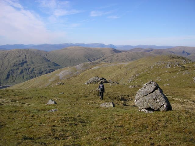
Beinn Heasgarnich (1077m) is one of the great upper Glen Lochay whalebacks — a vast, flat-topped Munro with a steep, broken north face dropping into the Allt Bad a' Mhaim. It sits centrally on the Breadalbane plateau and is almost always paired with Creag Mhòr to the west, with the two summits linked by a notorious peat-hagged bealach. The summit itself is a huge mossy plateau where finding the exact high point in mist requires good navigation.
Quick facts
- Height
- 1077.4m/ 3535ft
- Prominence
- 579 m
- Distance
- 18 km
- Ascent
- 948 m
- Time
- 6–9 hrs
- Grid ref
- NN413383
- Parking
- NN453408
- Nearest city
- Fort William· 47km
- Dogs
- Dogs on lead required near livestockDog-friendly guide ↗
Height and prominence cross-checked against the Database of British and Irish Hills (CC BY).
No GPX track yet
Walked this route? Share your track to help other walkers.
Standard route
Glen track 35% · Open hillside 35% · Summit plateau 30%
The standard approach is from the hairpin bend on the Glen Lochay–Glen Lyon hill road at Batavaime. Take the landrover track up Allt Batavaime, then climb the south-east shoulder onto the broad south ridge and the summit plateau. To traverse with Creag Mhòr, descend the steep west flank to the Bealach na Bidh — wet, peaty and slow — then climb the east ridge of Creag Mhòr. Return via the long south ridge of Creag Mhòr to the road. Roughly 17km in distance with 1100m of accumulated climb for the two-Munro round.
Terrain
The Batavaime landrover track is firm but gates need closing — working hill farm. The Allt Batavaime climb is rough heathery hillside with no clear path. The summit plateau is huge, mossy and almost featureless — a serious navigation challenge in cloud. The Bealach na Bidh between Heasgarnich and Creag Mhòr is among the worst peat-hag wading in the Breadalbane country, particularly after rain.
In winter
A serious winter plateau Munro. The plateau drifts deeply and finding the summit cairn in poor visibility demands precise navigation. The north face holds avalanche-prone snow after south-westerly loading; the Bealach na Bidh fills with deep wet snow that can be unwadable. Cornicing on the north rim is consistent. SAIS Southern Cairngorms is the closest regional indicator.
Best time of year
Getting there
- Glasgow2h 47m
- Edinburgh2h 15m
OS maps: OS Landranger 51
Mobile signal: No reception above 700m in upper Glen Lochay. Killin has 4G. Cache maps ahead of the run up the glen.
Current conditions
Daylight Today
- Sunrise
- 05:03
- Sunset
- 21:47
- Civil dawn
- 04:09
- Civil dusk
- 22:41
NOAA Solar Calculator · 23 July 2026
Got a photo of Beinn Sheasgarnaich (Beinn Heasgarnich)?
30 seconds, helps other walkers.
Submit a photoAround Beinn Sheasgarnaich (Beinn Heasgarnich) on the SCOT network
Getting there, basing yourself, and what to do off the hill.
Beinn Sheasgarnaich (Beinn Heasgarnich) — common questions
- Is Beinn Sheasgarnaich (Beinn Heasgarnich) a hard climb?
- Beinn Sheasgarnaich (Beinn Heasgarnich) is rated 4/5 (challenging) on the OutdoorSCOT scale. The standard route covers about 18km with 948m of ascent and takes most walkers 6-9 hours. Ground conditions: The Batavaime landrover track is firm but gates need closing — working hill farm.
- How much drop does Beinn Sheasgarnaich (Beinn Heasgarnich) have?
- The drop is 579m: measured from the summit of Beinn Sheasgarnaich (Beinn Heasgarnich) down to the saddle joining it to higher terrain.
- Where's the parking for Beinn Sheasgarnaich (Beinn Heasgarnich)?
- Park at NN453408. Double-check the grid reference on an OS map first; informal laybys here fill early in high season.
- What's the best month to climb Beinn Sheasgarnaich (Beinn Heasgarnich)?
- Aim for May, June, July, August, September, October on Beinn Sheasgarnaich (Beinn Heasgarnich). In the remaining months treat it as a winter hill — full kit, solid navigation, and a look at the relevant SAIS avalanche forecast before you go.
- Can dogs go up Beinn Sheasgarnaich (Beinn Heasgarnich)?
- Dogs are fine on a lead. The route passes livestock or ground-nesting bird habitat, so keep them close throughout.
- Will I get phone signal on Beinn Sheasgarnaich (Beinn Heasgarnich)?
- No reception above 700m in upper Glen Lochay. Killin has 4G. Cache maps ahead of the run up the glen.
- Is Beinn Sheasgarnaich (Beinn Heasgarnich) safe in winter?
- A serious winter plateau Munro. The plateau drifts deeply and finding the summit cairn in poor visibility demands precise navigation. The north face holds avalanche-prone snow after south-westerly loading; the Bealach na Bidh fills with deep wet snow that can be unwadable. Cornicing on the north rim is consistent. SAIS Southern Cairngorms is the closest regional indicator.
Get the OutdoorSCOT weekly
One email a week — new route, hill and bothy guides, seasonal conditions and the odd hard-won lesson. No spam, unsubscribe in one click.