Munro · Fife & Perthshire
Creag Mhor
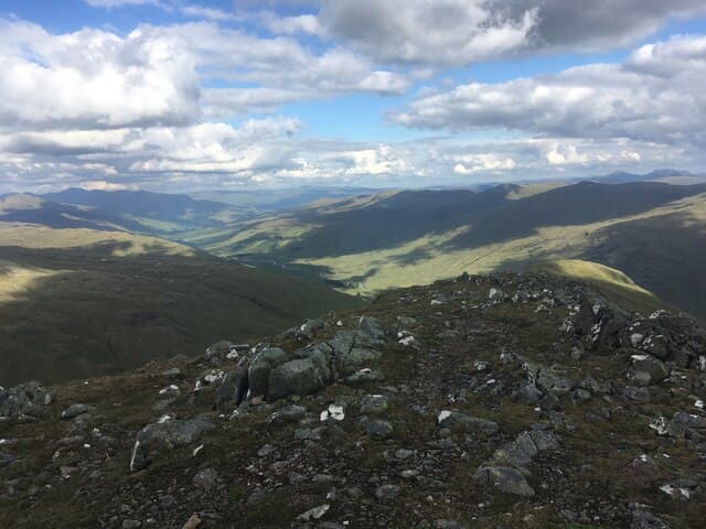
Creag Mhòr (1046m) is the rockier and shapelier neighbour of Beinn Heasgarnich at the head of Glen Lochay in the Breadalbane group. Where Heasgarnich is a vast mossy plateau, Creag Mhòr presents an exposed rocky summit ridge with steep crags falling to the east into Coire Cheathaich, a fine corrie that has given its name to a celebrated Gaelic poem by Duncan Bàn MacIntyre. Always tackled together with Heasgarnich and the two are notoriously linked by the boggy Bealach na Bidh.
Gaelic: “crag, big” · Pronunciation: krayg vore
Quick facts
- Height
- 1046.8m/ 3434ft
- Prominence
- 394 m
- Distance
- 18 km
- Ascent
- 921 m
- Time
- 6–9 hrs
- Grid ref
- NN391361
- Parking
- NN453408
- Nearest city
- Fort William· 47km
- Dogs
- Dogs on lead required near livestockDog-friendly guide ↗
Height and prominence cross-checked against the Database of British and Irish Hills (CC BY).
No GPX track yet
Walked this route? Share your track to help other walkers.
Standard route
Glen track 35% · Open hillside 35% · Rocky summit 30%
At the hairpin on the high road between Glen Lochay and Glen Lyon near Batavaime, follow the same landrover track east towards Heasgarnich for about a kilometre, then strike west on a rough path across the moor and into Coire Cheathaich. Climb the south ridge to the summit cairn. Most parties have started with Beinn Heasgarnich and arrive at Creag Mhòr via the Bealach na Bidh. The full pair is around 17km with 1100m of ascent.
Terrain
The Batavaime landrover track surface is firm; the crossing west into Coire Cheathaich is rough wet moor with no clear path. The south ridge of Creag Mhòr is steep grass and broken rock with a definite path higher up. The summit ridge is narrow rocky crest with sustained exposure on the east side above Coire Cheathaich. The Bealach na Bidh connecting it to Heasgarnich is the famous peat-hag slog — slow and tiring after rain.
In winter
A serious Breadalbane winter Munro with exposure to easterly weather across the plateau. The Coire Cheathaich east face holds avalanche-prone snow after south-westerly storms and gets little sun in midwinter. Cornicing on the east edge of the summit ridge is consistent. The Bealach na Bidh fills with deep wet snow. SAIS Southern Cairngorms is the closest regional reference. Glen Lochay road can be drifted.
Best time of year
Getting there
- Glasgow2h 45m
- Edinburgh2h 16m
OS maps: OS Landranger 50
Mobile signal: Zero signal above 700m in upper Glen Lochay. Killin has 4G. Stash maps before the journey.
Current conditions
Daylight Today
- Sunrise
- 05:03
- Sunset
- 21:47
- Civil dawn
- 04:09
- Civil dusk
- 22:41
NOAA Solar Calculator · 23 July 2026
Pair with
Curated multi-hill combinations from Creag Mhor.
Around Creag Mhor on the SCOT network
Getting there, basing yourself, and what to do off the hill.
Creag Mhor — common questions
- How hard is Creag Mhor?
- We grade Creag Mhor at 3/5, which puts it in moderately challenging territory. The usual route is around 18km with 921m of climbing; allow 6-9 hours. Terrain: The Batavaime landrover track surface is firm; the crossing west into Coire Cheathaich is rough wet moor with no clear path.
- How prominent is Creag Mhor?
- Creag Mhor has 394m of topographic prominence — the height of its summit above the highest col connecting it to higher ground.
- Where should I park to climb Creag Mhor?
- Standard parking is at NN453408. Check the parking grid reference on an OS map before travel; informal laybys can fill on summer weekends.
- When should I climb Creag Mhor?
- The standard good-weather months for Creag Mhor are May, June, July, August, September, October. Outside those months, expect winter conditions on the high ground — full mountain kit, navigation skills, and a check of the SAIS avalanche forecast for the relevant region.
- Can I bring my dog up Creag Mhor?
- On a lead only — the route crosses ground with livestock or nesting-bird interest.
- What's mobile reception like on Creag Mhor?
- Zero signal above 700m in upper Glen Lochay. Killin has 4G. Stash maps before the journey.
- Is Creag Mhor safe in winter?
- A serious Breadalbane winter Munro with exposure to easterly weather across the plateau. The Coire Cheathaich east face holds avalanche-prone snow after south-westerly storms and gets little sun in midwinter. Cornicing on the east edge of the summit ridge is consistent. The Bealach na Bidh fills with deep wet snow. SAIS Southern Cairngorms is the closest regional reference. Glen Lochay road can be drifted.
Get the OutdoorSCOT weekly
One email a week — new route, hill and bothy guides, seasonal conditions and the odd hard-won lesson. No spam, unsubscribe in one click.