Munro · Fife & Perthshire
Beinn Dorain
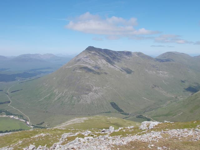
Beinn Dòrain (1076m) is one of the most instantly recognisable mountains in Scotland — the perfect cone seen end-on from the A82 as the road climbs out of Tyndrum. It is the subject of Duncan Bàn MacIntyre's great Gaelic poem "Moladh Beinn Dòbhrain" and a Munroist's rite of passage. The standard ascent from Bridge of Orchy is steep and direct; almost everyone pairs it with neighbouring Beinn an Dòthaidh on the same day.
Quick facts
- Height
- 1076m/ 3530ft
- Prominence
- 332 m
- Distance
- 18 km
- Ascent
- 947 m
- Time
- 6–9 hrs
- Grid ref
- NN325378
- Parking
- NN300394
- Nearest city
- Fort William· 42km
- Dogs
- Dogs on lead required near livestockDog-friendly guide ↗
Height and prominence cross-checked against the Database of British and Irish Hills (CC BY).
No GPX track yet
Walked this route? Share your track to help other walkers.
Standard route
Good path 35% · Steep hillside 45% · Summit cone 20%
Park at Bridge of Orchy station. Take the West Highland Way south briefly, then turn east on the well-engineered path that climbs into Coire an Dòthaidh between Dòrain and Dòthaidh. From the bealach a clear path heads south-east up the north ridge to a false summit, then south to the true cairn. Most parties return to the bealach and add Beinn an Dòthaidh. Around 12km with 1060m of ascent for the pair; Dòrain alone is 9km with 935m up.
Terrain
The path from Bridge of Orchy to the bealach is one of the best-engineered in the country — restored stone pitching for most of its length. Above the bealach the going is steep grass and broken rock, with a false summit cairn that catches out the inattentive in cloud. The true summit is a further 200m south. The drop into Coire an Dòthaidh on the descent is steep grass over slabby rock — slippery in the wet.
In winter
A popular winter Munro. The Coire an Dòthaidh path is sheltered from westerly weather; the bealach to summit ridge is fully exposed. The west face holds wind-loaded snow after westerly storms; cornicing on the east edge of the summit ridge can be substantial. The A82 corridor is reliably gritted and Bridge of Orchy station gives shelter. SAIS Glencoe is the closest report.
Best time of year
Getting there
- Glasgow2h 50m
- Edinburgh2h 24m
OS maps: OS Landranger 50
Mobile signal: Good signal at Bridge of Orchy station and hotel. Bars drop away above 700m. West Highland Way passes the trailhead — popular start point.
Current conditions
Daylight Today
- Sunrise
- 05:03
- Sunset
- 21:48
- Civil dawn
- 04:09
- Civil dusk
- 22:41
NOAA Solar Calculator · 23 July 2026
Pair with
Curated multi-hill combinations from Beinn Dorain.
Around Beinn Dorain on the SCOT network
Getting there, basing yourself, and what to do off the hill.
Getting there: Bridge of Orchy station
Black Mount; Beinn Dorain, Beinn an Dothaidh, Beinn Achaladair, Beinn a Chreachain
3km from the hill
tripscot.co.uk
On TripSCOTBase yourself in Fort William
Ben Nevis base, West Highland Line, gateway to Lochaber
42km from the hill
tripscot.co.uk
Beinn Dorain — common questions
- What difficulty is Beinn Dorain?
- On the OutdoorSCOT scale, Beinn Dorain comes in at 4/5 — challenging. Expect roughly 18km and 947m of ascent on the usual route — 6-9 hours for most parties. Terrain: The path from Bridge of Orchy to the bealach is one of the best-engineered in the country — restored stone pitching for most of its length.
- How prominent is Beinn Dorain?
- Beinn Dorain has 332m of topographic prominence — the height of its summit above the highest col connecting it to higher ground.
- Where should I park to climb Beinn Dorain?
- Standard parking is at NN300394. Check the parking grid reference on an OS map before travel; informal laybys can fill on summer weekends.
- When should I climb Beinn Dorain?
- The standard good-weather months for Beinn Dorain are May, June, July, August, September, October. Outside those months, expect winter conditions on the high ground — full mountain kit, navigation skills, and a check of the SAIS avalanche forecast for the relevant region.
- Can I bring my dog up Beinn Dorain?
- On a lead only — the route crosses ground with livestock or nesting-bird interest.
- What's mobile reception like on Beinn Dorain?
- Good signal at Bridge of Orchy station and hotel. Bars drop away above 700m. West Highland Way passes the trailhead — popular start point.
- Is Beinn Dorain safe in winter?
- A popular winter Munro. The Coire an Dòthaidh path is sheltered from westerly weather; the bealach to summit ridge is fully exposed. The west face holds wind-loaded snow after westerly storms; cornicing on the east edge of the summit ridge can be substantial. The A82 corridor is reliably gritted and Bridge of Orchy station gives shelter. SAIS Glencoe is the closest report.
Get the OutdoorSCOT weekly
One email a week — new route, hill and bothy guides, seasonal conditions and the odd hard-won lesson. No spam, unsubscribe in one click.