Munro · Fife & Perthshire
Beinn a' Chreachain
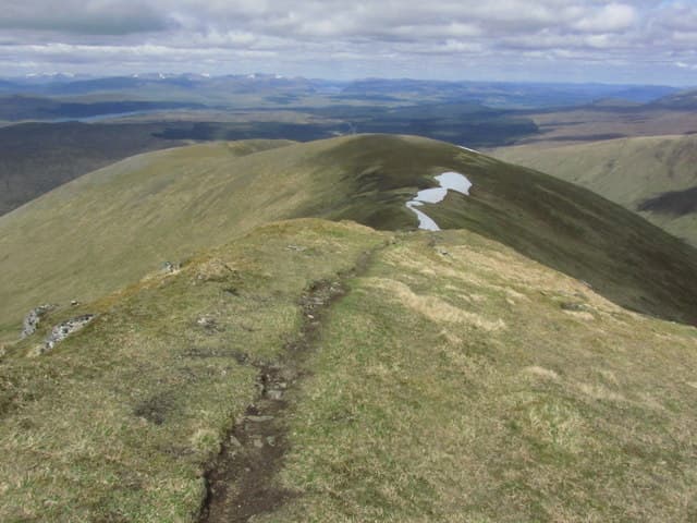
Beinn a' Chreachain (1080m) is the easternmost and highest of the four Bridge of Orchy Munros — the long ridge that walls in the northern edge of Loch Tulla above Rannoch Moor. The summit gives one of the great panoramic views of the Moor itself, a vast watery wilderness stretching east to Schiehallion and Ben Alder. Usually combined with Beinn an Dòthaidh and often with Beinn Achaladair and Beinn Dorain in a single round.
Quick facts
- Height
- 1080.6m/ 3545ft
- Prominence
- 650 m
- Distance
- 18 km
- Ascent
- 951 m
- Time
- 6–9 hrs
- Grid ref
- NN373440
- Parking
- NN322443
- Nearest city
- Fort William· 40km
- Dogs
- Dogs on lead required near livestockDog-friendly guide ↗
Height and prominence cross-checked against the Database of British and Irish Hills (CC BY).
No GPX track yet
Walked this route? Share your track to help other walkers.
Standard route
Farm track / glen path 35% · Open hillside 40% · Summit ridge 25%
Park at Achallader Farm just off the A82. Follow the access track east under the West Highland Line viaduct, then up the Coire Achaladair to the bealach between Beinn Achaladair and Beinn a' Chreachain. Most parties traverse both summits, returning via the Crannach woods and the Water of Tulla. Around 18km with 950m of ascent for the pair; Beinn a' Chreachain alone is 14km with 950m up.
Terrain
The Achallader access track is firm landrover surface for the first 3km. The ancient Crannach Caledonian pinewood is a delight in itself but the path through it is rough, boggy and root-tangled. Above the trees the climb onto Meall Buidhe is steep grass; the broad summit ridge is a mix of mossy turf, gravel and stone. The descent off Beinn Achaladair towards Coire Dhaimh is steep and slippery on wet rock.
In winter
A serious Bridge of Orchy winter ridge. Cornicing along the south-facing crest is consistent through the season. The Coire an Lochain headwall holds avalanche-prone snow after westerly loading. The Achallader approach can be drifted closed in heavy snow. SAIS Glencoe is the closest report, though the hills sit beyond its formal zone. Full winter kit essential.
Best time of year
Getting there
- Glasgow2h 44m
- Edinburgh2h 24m
OS maps: OS Landranger 50
Mobile signal: No bars above 700m on the Rannoch Moor edge. Bridge of Orchy has reasonable 4G. Cache mapping before the drive north from Tyndrum.
Current conditions
Daylight Today
- Sunrise
- 05:03
- Sunset
- 21:48
- Civil dawn
- 04:09
- Civil dusk
- 22:42
NOAA Solar Calculator · 23 July 2026
Pair with
Curated multi-hill combinations from Beinn a' Chreachain.
Around Beinn a' Chreachain on the SCOT network
Getting there, basing yourself, and what to do off the hill.
Getting there: Bridge of Orchy station
Black Mount; Beinn Dorain, Beinn an Dothaidh, Beinn Achaladair, Beinn a Chreachain
9km from the hill
tripscot.co.uk
On TripSCOTBase yourself in Fort William
Ben Nevis base, West Highland Line, gateway to Lochaber
40km from the hill
tripscot.co.uk
Beinn a' Chreachain — common questions
- Is Beinn a' Chreachain a hard climb?
- Beinn a' Chreachain is rated 4/5 (challenging) on the OutdoorSCOT scale. The standard route covers about 18km with 951m of ascent and takes most walkers 6-9 hours. Terrain: The Achallader access track is firm landrover surface for the first 3km.
- How prominent is Beinn a' Chreachain?
- Beinn a' Chreachain has 650m of topographic prominence — the height of its summit above the highest col connecting it to higher ground.
- Where should I park to climb Beinn a' Chreachain?
- Standard parking is at NN322443. Check the parking grid reference on an OS map before travel; informal laybys can fill on summer weekends.
- When should I climb Beinn a' Chreachain?
- The standard good-weather months for Beinn a' Chreachain are May, June, July, August, September, October. Outside those months, expect winter conditions on the high ground — full mountain kit, navigation skills, and a check of the SAIS avalanche forecast for the relevant region.
- Can I bring my dog up Beinn a' Chreachain?
- On a lead only — the route crosses ground with livestock or nesting-bird interest.
- What's mobile reception like on Beinn a' Chreachain?
- No bars above 700m on the Rannoch Moor edge. Bridge of Orchy has reasonable 4G. Cache mapping before the drive north from Tyndrum.
- Is Beinn a' Chreachain safe in winter?
- A serious Bridge of Orchy winter ridge. Cornicing along the south-facing crest is consistent through the season. The Coire an Lochain headwall holds avalanche-prone snow after westerly loading. The Achallader approach can be drifted closed in heavy snow. SAIS Glencoe is the closest report, though the hills sit beyond its formal zone. Full winter kit essential.
Get the OutdoorSCOT weekly
One email a week — new route, hill and bothy guides, seasonal conditions and the odd hard-won lesson. No spam, unsubscribe in one click.