Corbett · Fife & Perthshire
Meall Buidhe
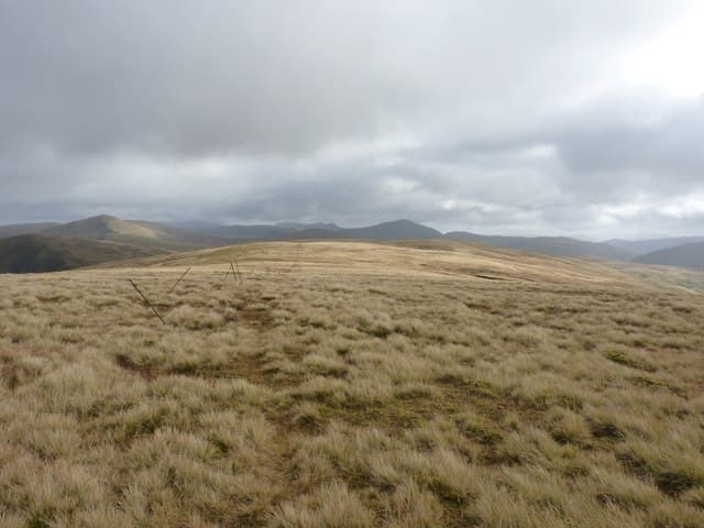
This is the Glen Lochay Meall Buidhe — one of several hills of the same name across the Highlands — a 908m grassy dome on the north side of upper Glen Lochay between Kenknock and the Lairig nan Lunn. The hill links naturally to the Munros Creag Mhor and Beinn Heasgarnich to its north, but stands far enough apart for a satisfying single day. Its yellow tussocky flanks (Meall Buidhe means "yellow hill") give wide views down Glen Lochay to Loch Tay and across the Lawers range.
Gaelic: “rounded hill, yellow” · Pronunciation: myowl boo-yeh
Quick facts
- Height
- 908.4m/ 2980ft
- Prominence
- 259 m
- Distance
- 16 km
- Ascent
- 799 m
- Time
- 5–8 hrs
- Grid ref
- NN426449
- Parking
- NN457368
- Nearest city
- Fort William· 43km
- Dogs
- Dogs on lead required near livestockDog-friendly guide ↗
Height and prominence cross-checked against the Database of British and Irish Hills (CC BY).
No GPX track yet
Walked this route? Share your track to help other walkers.
Standard route
hydro track 30% · open grass 40% · grassy ridge 25% · summit dome 5%
Drive up Glen Lochay from Killin to Kenknock and continue west toward the Lairig nan Lunn track. From the parking area at the south end of the hydro road, follow the track north over the Lairig pass into the upper glen of the Allt a Chobhair. Quit the track and pull up rough grass eastwards to gain the south-west ridge of Meall Buidhe, then follow the ridge to the summit. Around 16km with 799m of ascent. Return by the same line or extend over Creag Mhor.
Terrain
The Lairig nan Lunn hydro track is a well-graded surface for the climb out of Glen Lochay. Off the track the ground is a mix of short grass and bog — slow in wet conditions but with no path-finding difficulty. The summit is broad and rounded, with no exposure or rocky steps. Under cloud a steady compass bearing is essential to leave the top in the right direction; the surrounding ground all looks similar.
In winter
A relatively safe winter hill — no steep avalanche slopes and the gradients are gentle throughout. The Lairig nan Lunn is one of the highest road passes around the Lawers area and the road can drift up. Once on the hill the main concerns are wind exposure on the open dome and finding the correct line off in poor visibility. The Glen Lochay road is single-track and not gritted in its upper sections.
Best time of year
Getting there
- Glasgow2h 44m
- Edinburgh2h 19m
OS maps: OS Landranger 51
Mobile signal: Poor signal in upper Glen Lochay; intermittent at the dam
Current conditions
Daylight Today
- Sunrise
- 04:46
- Sunset
- 22:02
- Civil dawn
- 03:47
- Civil dusk
- 23:01
NOAA Solar Calculator · 13 July 2026
Around Meall Buidhe on the SCOT network
Getting there, basing yourself, and what to do off the hill.
Meall Buidhe — common questions
- Is Meall Buidhe a hard climb?
- Meall Buidhe is rated 3/5 (moderately challenging) on the OutdoorSCOT scale. The standard route covers about 16km with 799m of ascent and takes most walkers 5-8 hours. Terrain: The Lairig nan Lunn hydro track is a well-graded surface for the climb out of Glen Lochay.
- How prominent is Meall Buidhe?
- Meall Buidhe has 259m of topographic prominence — the height of its summit above the highest col connecting it to higher ground.
- Where should I park to climb Meall Buidhe?
- Standard parking is at NN457368. Check the parking grid reference on an OS map before travel; informal laybys can fill on summer weekends.
- When should I climb Meall Buidhe?
- The standard good-weather months for Meall Buidhe are May, June, July, August, September, October. Outside those months, expect winter conditions on the high ground — full mountain kit, navigation skills, and a check of the SAIS avalanche forecast for the relevant region.
- Can I bring my dog up Meall Buidhe?
- On a lead only — the route crosses ground with livestock or nesting-bird interest.
- What's mobile reception like on Meall Buidhe?
- Poor signal in upper Glen Lochay; intermittent at the dam
- Is Meall Buidhe safe in winter?
- A relatively safe winter hill — no steep avalanche slopes and the gradients are gentle throughout. The Lairig nan Lunn is one of the highest road passes around the Lawers area and the road can drift up. Once on the hill the main concerns are wind exposure on the open dome and finding the correct line off in poor visibility. The Glen Lochay road is single-track and not gritted in its upper sections.
Get the OutdoorSCOT weekly
One email a week — new route, hill and bothy guides, seasonal conditions and the odd hard-won lesson. No spam, unsubscribe in one click.