Corbett · Fife & Perthshire
Cam Chreag
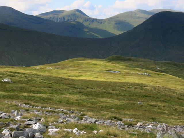
This Cam Chreag — "crooked crag" — is the northern Corbett of the Auch group, immediately east of Beinn a' Chaisteil and north of the A82 between Tyndrum and Bridge of Orchy. At 883m it is a hill of grass and broken crags, its name reflecting the band of small rocky outcrops on its south-east face. The summit is broad and rounded with views west across to Ben Dorain and east into the upper Glen Lyon hills. Like its neighbours it sees little traffic outside the bagging community.
Quick facts
- Height
- 883.6m/ 2899ft
- Prominence
- 158 m
- Distance
- 16 km
- Ascent
- 777 m
- Time
- 5–8 hrs
- Grid ref
- NN375346
- Parking
- NN317355
- Nearest city
- Fort William· 48km
- Dogs
- Dogs on lead required near livestockDog-friendly guide ↗
Height and prominence cross-checked against the Database of British and Irish Hills (CC BY).
No GPX track yet
Walked this route? Share your track to help other walkers.
Standard route
estate track 25% · broad south ridge 55% · grassy upper slopes 15% · summit cairn 5%
Most parties combine Cam Chreag with Beinn a' Chaisteil from a single start at Auch on the A82. Walk in along the Auch estate track, then leave the West Highland Way and climb the long broad south ridge directly to the summit dome. The traverse north over to Beinn Mhanach (a Munro) adds another full day. Around 16km with 777m of ascent for the pair. Estate ground; check stalking season activity before going.
Terrain
The estate track approach is good and the lower hillside is grassy with patches of crag — the small rocky steps on the south-east face are easily skirted on the right. Above, the going turns to short grass and crowberry with no path. The summit dome itself is featureless apart from the small cairn. No exposure, no scrambling, no significant route-finding difficulties in clear weather.
In winter
A relatively safe winter Corbett — no avalanche-prone slopes, gentle gradients and a manageable distance from the road. The south-east crag band catches sun and rarely holds verglas. The principal winter concerns are gusty exposure on the open dome and the cold sweep of the A82 corridor. Pairing with Beinn a' Chaisteil for a double makes a substantial winter day.
Best time of year
Getting there
- Glasgow2h 44m
- Edinburgh2h 16m
OS maps: OS Landranger 50, OS Explorer 377
Mobile signal: Reasonable signal on the A82 corridor; usable on the summit
Current conditions
Daylight Today
- Sunrise
- 04:53
- Sunset
- 21:56
- Civil dawn
- 03:56
- Civil dusk
- 22:53
NOAA Solar Calculator · 17 July 2026
Pair with
Curated multi-hill combinations from Cam Chreag.
Around Cam Chreag on the SCOT network
Getting there, basing yourself, and what to do off the hill.
Cam Chreag — common questions
- How difficult is Cam Chreag?
- Cam Chreag carries a 3/5 (moderately challenging) grade on the OutdoorSCOT scale. Count on about 16km, 777m of ascent and a 5-8 hour day on the standard route. Underfoot: The estate track approach is good and the lower hillside is grassy with patches of crag — the small rocky steps on the south-east face are easily skirted on the right.
- What is Cam Chreag's prominence?
- 158m of prominence. That's the vertical drop from the summit to the col that links Cam Chreag to the next higher ground.
- Where do I park for Cam Chreag?
- Most walkers start from NN317355. Verify the grid reference on an OS map before you set off — space is tight on busy summer weekends.
- When is the best time to climb Cam Chreag?
- May, June, July, August, September, October give the most reliable conditions on Cam Chreag. Beyond that window the high ground turns wintry: carry full mountain kit, be confident navigating, and check the SAIS avalanche forecast for the area.
- Is Cam Chreag dog-friendly?
- Yes, but dogs must be kept on a lead — there is livestock or ground-nesting bird interest on the route.
- Is there mobile signal on Cam Chreag?
- Reasonable signal on the A82 corridor; usable on the summit
- Is Cam Chreag safe in winter?
- A relatively safe winter Corbett — no avalanche-prone slopes, gentle gradients and a manageable distance from the road. The south-east crag band catches sun and rarely holds verglas. The principal winter concerns are gusty exposure on the open dome and the cold sweep of the A82 corridor. Pairing with Beinn a' Chaisteil for a double makes a substantial winter day.
Get the OutdoorSCOT weekly
One email a week — new route, hill and bothy guides, seasonal conditions and the odd hard-won lesson. No spam, unsubscribe in one click.