Corbett · Fife & Perthshire
Beinn Odhar
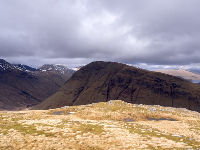
Beinn Odhar is the shapely cone rising directly above Tyndrum on the A82 — every driver heading north to Glen Coe or Fort William sees it, and many a hillwalker has bagged it on a quick stop on the way home from somewhere further west. The 901m summit gives a panoramic view across Strath Fillan to Ben More and Stob Binnein, north to Beinn Dorain's flanks, and west into Glen Lochy. The walk is short, sharp, and almost cartoonishly simple in shape: a steady climb up a grass cone with no route-finding required.
Quick facts
- Height
- 900.8m/ 2955ft
- Prominence
- 457 m
- Distance
- 8 km
- Ascent
- 730 m
- Time
- 2–4 hrs
- Grid ref
- NN337338
- Parking
- NN329308
- Nearest city
- Fort William· 46km
- Dogs
- Dogs on lead required near livestockDog-friendly guide ↗
Height and prominence cross-checked against the Database of British and Irish Hills (CC BY).
No GPX track yet
Walked this route? Share your track to help other walkers.
Standard route
roadside grass 20% · heather slope 40% · grassy ridge 30% · summit area 10%
Park in the lay-by just north of Tyndrum at Auchertyre or use the village car park. From either, cross the railway and pick up the path heading north onto Beinn Odhar's south ridge. The route climbs steadily and almost continuously over grass and heather to the summit. There are no false tops to speak of; the hill is the climb. The descent reverses the line, or for a longer day continue north over the saddle to Beinn Chaorach. Allow 3.5–4.5 hours.
Terrain
Grass and heather throughout — wet on the lower flanks, drier on the upper cone. A clear path of sorts, made by feet rather than estate work, runs most of the way. The summit area is broad and grassy with a modest cairn. Easier underfoot than most western Corbetts.
In winter
An excellent winter introduction Corbett — the cone shape gives no avalanche-prone steep ground, the route is hard to lose, and access from Tyndrum is reliable in all but the worst weather. Snow holds well on the north-east aspect. Crampons rarely essential; axe helpful for confidence on the upper grass. Great early-season fitness day.
Best time of year
Getting there
- Glasgow2h 44m
- Edinburgh2h 20m
OS maps: OS Landranger 50
Mobile signal: Reasonable EE/Vodafone in Tyndrum village; intermittent on the upper south ridge; usable on the summit in direct view of the A82
Current conditions
Daylight Today
- Sunrise
- 04:47
- Sunset
- 22:02
- Civil dawn
- 03:49
- Civil dusk
- 23:01
NOAA Solar Calculator · 13 July 2026
Around Beinn Odhar on the SCOT network
Getting there, basing yourself, and what to do off the hill.
Beinn Odhar — common questions
- How hard is Beinn Odhar?
- We grade Beinn Odhar at 2/5, which puts it in moderate territory. The usual route is around 8km with 730m of climbing; allow 2-4 hours. Ground conditions: Grass and heather throughout — wet on the lower flanks, drier on the upper cone.
- How much drop does Beinn Odhar have?
- The drop is 457m: measured from the summit of Beinn Odhar down to the saddle joining it to higher terrain.
- Where's the parking for Beinn Odhar?
- Park at NN329308. Double-check the grid reference on an OS map first; informal laybys here fill early in high season.
- What's the best month to climb Beinn Odhar?
- Aim for May, June, July, August, September, October on Beinn Odhar. In the remaining months treat it as a winter hill — full kit, solid navigation, and a look at the relevant SAIS avalanche forecast before you go.
- Can dogs go up Beinn Odhar?
- Dogs are fine on a lead. The route passes livestock or ground-nesting bird habitat, so keep them close throughout.
- Will I get phone signal on Beinn Odhar?
- Reasonable EE/Vodafone in Tyndrum village; intermittent on the upper south ridge; usable on the summit in direct view of the A82
- Is Beinn Odhar safe in winter?
- An excellent winter introduction Corbett — the cone shape gives no avalanche-prone steep ground, the route is hard to lose, and access from Tyndrum is reliable in all but the worst weather. Snow holds well on the north-east aspect. Crampons rarely essential; axe helpful for confidence on the upper grass. Great early-season fitness day.
Get the OutdoorSCOT weekly
One email a week — new route, hill and bothy guides, seasonal conditions and the odd hard-won lesson. No spam, unsubscribe in one click.