Corbett · Fife & Perthshire
Beinn nan Oighreag
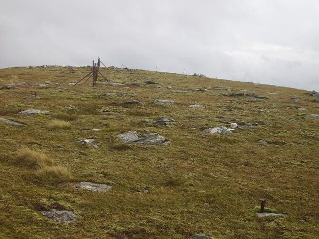
Beinn nan Oighreag is a quiet grassy Corbett on the watershed between Glen Lochay and Glen Lyon, sandwiched between the busier Munros of the Lawers and Mamlorn groups. At 909m it is a hill of broad horizons rather than dramatic features — short heather and bilberry slopes leading to a wide green summit dome with a single boulder marking the top. The view eastward along Glen Lyon to Schiehallion is the highlight, and on a clear day Ben More and Stob Binnein dominate the southern skyline.
Gaelic: “mountain, of the, cloudberry” · Pronunciation: bine nan oighreag
Quick facts
- Height
- 909.6m/ 2984ft
- Prominence
- 272 m
- Distance
- 16 km
- Ascent
- 800 m
- Time
- 5–8 hrs
- Grid ref
- NN541412
- Parking
- NN465360
- Nearest city
- Stirling· 54km
- Dogs
- Dogs on lead required near livestockDog-friendly guide ↗
Height and prominence cross-checked against the Database of British and Irish Hills (CC BY).
No GPX track yet
Walked this route? Share your track to help other walkers.
Standard route
hydro track 40% · short grass 35% · grassy ridge 20% · summit dome 5%
Park beside the dam at the head of Loch Lyon or at Kenknock in Glen Lochay and take an Argocat track up the south flank of the hill. The track peters out around 600m and grassy ridge walking leads to the summit. Around 16km return with 800m of ascent on the longer Glen Lochay approach; shorter from Loch Lyon dam if road access is available. The hill is often paired with Meall nan Subh or the Lawers outliers for a double day.
Terrain
The hydro and estate tracks in Glen Lochay are firm and well drained, giving an easy approach. Once off the track the surface becomes short turf and crowberry — pleasant walking with no path but generally firm footing. The summit dome is featureless and can be confusing in mist; the cairn lies a short distance from the highest point. There is no exposure or scrambling at any point on the hill.
In winter
A relatively benign winter hill by Central Highland standards — gentle gradients, no cornices and no avalanche slopes of consequence. The chief winter dangers here are weather exposure on the bare summit dome and disorientation in whiteout. The Glen Lochay road becomes single-track and slippery after snowfall. Daylight hours in late December limit the day; an early start helps.
Best time of year
Getting there
- Glasgow2h 48m
- Edinburgh2h 5m
OS maps: OS Landranger 51
Mobile signal: Poor signal on this remote Rannoch plateau hill
Current conditions
Daylight Today
- Sunrise
- 04:45
- Sunset
- 22:01
- Civil dawn
- 03:46
- Civil dusk
- 23:00
NOAA Solar Calculator · 13 July 2026
Pair with
Curated multi-hill combinations from Beinn nan Oighreag.
Around Beinn nan Oighreag on the SCOT network
Getting there, basing yourself, and what to do off the hill.
Beinn nan Oighreag — common questions
- Is Beinn nan Oighreag a hard climb?
- Beinn nan Oighreag is rated 3/5 (moderately challenging) on the OutdoorSCOT scale. The standard route covers about 16km with 800m of ascent and takes most walkers 5-8 hours. Ground conditions: The hydro and estate tracks in Glen Lochay are firm and well drained, giving an easy approach.
- How much drop does Beinn nan Oighreag have?
- The drop is 272m: measured from the summit of Beinn nan Oighreag down to the saddle joining it to higher terrain.
- Where's the parking for Beinn nan Oighreag?
- Park at NN465360. Double-check the grid reference on an OS map first; informal laybys here fill early in high season.
- What's the best month to climb Beinn nan Oighreag?
- Aim for May, June, July, August, September, October on Beinn nan Oighreag. In the remaining months treat it as a winter hill — full kit, solid navigation, and a look at the relevant SAIS avalanche forecast before you go.
- Can dogs go up Beinn nan Oighreag?
- Dogs are fine on a lead. The route passes livestock or ground-nesting bird habitat, so keep them close throughout.
- Will I get phone signal on Beinn nan Oighreag?
- Poor signal on this remote Rannoch plateau hill
- Is Beinn nan Oighreag safe in winter?
- A relatively benign winter hill by Central Highland standards — gentle gradients, no cornices and no avalanche slopes of consequence. The chief winter dangers here are weather exposure on the bare summit dome and disorientation in whiteout. The Glen Lochay road becomes single-track and slippery after snowfall. Daylight hours in late December limit the day; an early start helps.
Get the OutdoorSCOT weekly
One email a week — new route, hill and bothy guides, seasonal conditions and the odd hard-won lesson. No spam, unsubscribe in one click.