Corbett · Fife & Perthshire
Meall nam Maigheach
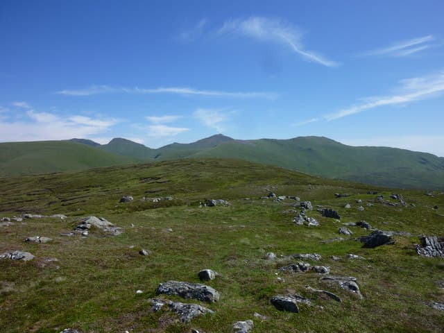
Meall nam Maigheach — "hill of the hares" — is a quiet 778m Corbett above Loch an Daimh in upper Glen Lyon, on the watershed between Glen Lyon and Glen Lochay. The summit is a small rocky cairn on a wide turfy dome with a fine outlook east toward Schiehallion and west into the empty country of the Loch Lyon hills. It is often combined with the Munros Stuchd an Lochain or Meall Buidhe for a more substantial day.
Quick facts
- Height
- 778.9m/ 2555ft
- Prominence
- 176 m
- Distance
- 14 km
- Ascent
- 638 m
- Time
- 4–7 hrs
- Grid ref
- NN585436
- Parking
- NN509464
- Nearest city
- Stirling· 54km
- Dogs
- Dogs on lead required near livestockDog-friendly guide ↗
Height and prominence cross-checked against the Database of British and Irish Hills (CC BY).
No GPX track yet
Walked this route? Share your track to help other walkers.
Standard route
dam-side path 25% · open grass 35% · broad ridge 30% · rock cairn 10%
Start from the small lay-by at the Giorra dam below Loch an Daimh in upper Glen Lyon. Cross the dam and follow the southern shore of the loch westward for a short distance, then climb open grass slopes north onto the broad east ridge of Meall nam Maigheach. An undemanding climb on the ridge ends at the cairn. About 14km out-and-back with 638m of climbing.
Terrain
The dam-side path is firm. Off the path the ground is short heather and grass with no path — easy walking but slow over patches of bog. The summit area is broad short turf with a small rock cairn at the high point. No exposure or scrambling. Stalking activity in season; check estate notices.
In winter
A gentle winter Corbett — gentle gradients, no avalanche concerns, broad summit dome that picks up snow but holds no cornices. The Glen Lyon road in is single-track and rarely gritted past Bridge of Balgie; access can be slow after heavy snowfall. Daylight is short midwinter.
Best time of year
Getting there
- Glasgow2h 52m
- Edinburgh2h 3m
OS maps: OS Landranger 51
Mobile signal: Zero signal in upper Glen Lyon; nothing on the hill
Current conditions
Daylight Today
- Sunrise
- 04:45
- Sunset
- 22:01
- Civil dawn
- 03:46
- Civil dusk
- 23:00
NOAA Solar Calculator · 13 July 2026
Pair with
Curated multi-hill combinations from Meall nam Maigheach.
Around Meall nam Maigheach on the SCOT network
Getting there, basing yourself, and what to do off the hill.
Getting there: Rannoch station
Rannoch Moor — remote West Highland Line stop; Schiehallion approach via bus
22km from the hill
tripscot.co.uk
On TripSCOTBase yourself in Aberfeldy
Loch Tay base — Ben Lawers, Tarmachan ridge, Birks of Aberfeldy
28km from the hill
tripscot.co.uk
On TasteSCOTAfter the hill: Aberfeldy
Aberfeldy — heart of Dewar's blends; honey-and-heather Highland style
28km from the hill
tastescot.co.uk
Meall nam Maigheach — common questions
- How difficult is Meall nam Maigheach?
- Meall nam Maigheach carries a 2/5 (moderate) grade on the OutdoorSCOT scale. Count on about 14km, 638m of ascent and a 4-7 hour day on the standard route. Ground conditions: The dam-side path is firm.
- How much drop does Meall nam Maigheach have?
- The drop is 176m: measured from the summit of Meall nam Maigheach down to the saddle joining it to higher terrain.
- Where's the parking for Meall nam Maigheach?
- Park at NN509464. Double-check the grid reference on an OS map first; informal laybys here fill early in high season.
- What's the best month to climb Meall nam Maigheach?
- Aim for April, May, June, July, August, September, October on Meall nam Maigheach. In the remaining months treat it as a winter hill — full kit, solid navigation, and a look at the relevant SAIS avalanche forecast before you go.
- Can dogs go up Meall nam Maigheach?
- Dogs are fine on a lead. The route passes livestock or ground-nesting bird habitat, so keep them close throughout.
- Will I get phone signal on Meall nam Maigheach?
- Zero signal in upper Glen Lyon; nothing on the hill
- Is Meall nam Maigheach safe in winter?
- A gentle winter Corbett — gentle gradients, no avalanche concerns, broad summit dome that picks up snow but holds no cornices. The Glen Lyon road in is single-track and rarely gritted past Bridge of Balgie; access can be slow after heavy snowfall. Daylight is short midwinter.
Get the OutdoorSCOT weekly
One email a week — new route, hill and bothy guides, seasonal conditions and the odd hard-won lesson. No spam, unsubscribe in one click.