Munro · Fife & Perthshire
Meall nan Tarmachan
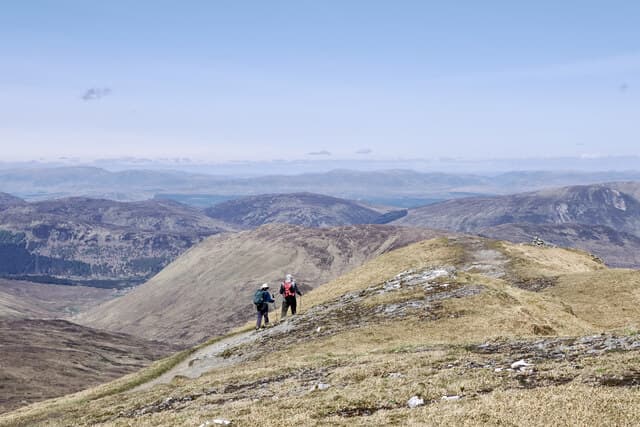
Meall nan Tarmachan (1043m) — "hill of the ptarmigan" — is the highest summit of the Tarmachan Ridge, the rocky knobbly chain of tops immediately west of the Ben Lawers range. Although only one of the four tops is a Munro, the full traverse is one of the finest short ridge walks in Scotland — a series of grassy and rocky humps, mild scrambling, and continuous views over Loch Tay and across to the Ben Lawers wall. Ptarmigan, true to the name, are commonly seen above 900m.
Quick facts
- Height
- 1043.6m/ 3424ft
- Prominence
- 494 m
- Distance
- 12.5 km
- Ascent
- 900 m
- Time
- 5–7 hrs
- Grid ref
- NN585390
- Parking
- NN608379
- Nearest city
- Stirling· 50km
- Dogs
- Dogs on lead required near livestockDog-friendly guide ↗
Height and prominence cross-checked against the Database of British and Irish Hills (CC BY).
No GPX track yet
Walked this route? Share your track to help other walkers.
Standard route
Good path 35% · Rocky ridge 45% · Return moorland 20%
Start from the National Trust car park on the Ben Lawers high road below the Visitor Centre. Walk west along the contouring path, then climb north onto the south-east ridge of Meall nan Tarmachan. Continue west along the Tarmachan Ridge over Meall Garbh, Beinn nan Eachan and Creag na Caillich, then descend south-east on rough hillside back to the car park. Around 12.5km with 900m of ascent — a relatively short but classic ridge day.
Terrain
The NTS approach path is well-maintained pitching for the first kilometre. Above the path the climb to Meall nan Tarmachan summit is steep but easy grass. The connecting ridge between the four tops is the technical interest — narrow rocky crest with several short scrambly steps, including the awkward "bad step" rocky downclimb west of Meall Garbh. Bypasses on the north side exist for nervous walkers. The Creag na Caillich descent is steep and slippery on wet grass.
In winter
A serious short winter day. The bad step and rocky scrambling sections become genuine winter mountaineering moves in snow and ice. Cornicing on the north sides of the ridges is consistent through the season. The NTS high road approach can drift closed in heavy snow — check road status before driving. SAIS Southern Cairngorms is the closest formal forecast. Phone signal weakens above 800m.
Best time of year
Getting there
- Glasgow2h 45m
- Edinburgh2h 59m
OS maps: OS Landranger 51
Mobile signal: Good signal at the Ben Lawers (NTS) car park area. Bars drop away above 800m.
Current conditions
Daylight Today
- Sunrise
- 05:01
- Sunset
- 21:46
- Civil dawn
- 04:07
- Civil dusk
- 22:40
NOAA Solar Calculator · 23 July 2026
Around Meall nan Tarmachan on the SCOT network
Getting there, basing yourself, and what to do off the hill.
Getting there: Crianlarich station
Crianlarich Munros — Ben More, Stob Binnein, Ben Lui, Cruach Ardrain
24km from the hill
tripscot.co.uk
On TripSCOTBase yourself in Aberfeldy
Loch Tay base — Ben Lawers, Tarmachan ridge, Birks of Aberfeldy
29km from the hill
tripscot.co.uk
On TasteSCOTAfter the hill: Aberfeldy
Aberfeldy — heart of Dewar's blends; honey-and-heather Highland style
29km from the hill
tastescot.co.uk
Meall nan Tarmachan — common questions
- How hard is Meall nan Tarmachan?
- We grade Meall nan Tarmachan at 4/5, which puts it in challenging territory. The usual route is around 12.5km with 900m of climbing; allow 5-7 hours. Terrain: The NTS approach path is well-maintained pitching for the first kilometre.
- How prominent is Meall nan Tarmachan?
- Meall nan Tarmachan has 494m of topographic prominence — the height of its summit above the highest col connecting it to higher ground.
- Where should I park to climb Meall nan Tarmachan?
- Standard parking is at NN608379. Check the parking grid reference on an OS map before travel; informal laybys can fill on summer weekends.
- When should I climb Meall nan Tarmachan?
- The standard good-weather months for Meall nan Tarmachan are May, June, July, August, September, October. Outside those months, expect winter conditions on the high ground — full mountain kit, navigation skills, and a check of the SAIS avalanche forecast for the relevant region.
- Can I bring my dog up Meall nan Tarmachan?
- On a lead only — the route crosses ground with livestock or nesting-bird interest.
- What's mobile reception like on Meall nan Tarmachan?
- Good signal at the Ben Lawers (NTS) car park area. Bars drop away above 800m.
- Is Meall nan Tarmachan safe in winter?
- A serious short winter day. The bad step and rocky scrambling sections become genuine winter mountaineering moves in snow and ice. Cornicing on the north sides of the ridges is consistent through the season. The NTS high road approach can drift closed in heavy snow — check road status before driving. SAIS Southern Cairngorms is the closest formal forecast. Phone signal weakens above 800m.
Get the OutdoorSCOT weekly
One email a week — new route, hill and bothy guides, seasonal conditions and the odd hard-won lesson. No spam, unsubscribe in one click.