Munro · Fife & Perthshire
Ben Lawers
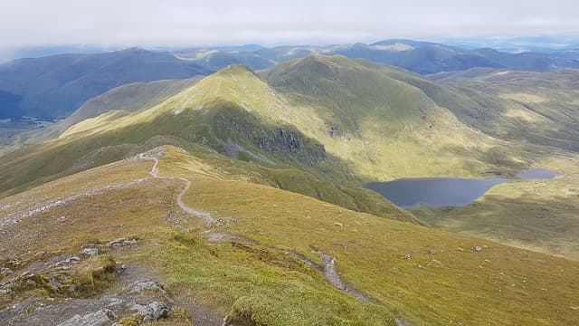
Ben Lawers is the highest Munro south of Strath Tay at 1214m, towering above Loch Tay and the village of Killin. With 914m of prominence it dominates Perthshire and gives a 360-degree view from the Cairngorms to the Arrochar Alps. The hill is owned by the National Trust for Scotland as a National Nature Reserve, protecting the largest expanse of arctic-alpine flora in southern Scotland — alpine forget-me-not and rare gentians grow on the schist outcrops here. The summit is a trig point on a small rocky platform at the head of a long undulating ridge of seven Munros.
Quick facts
- Height
- 1214.3m/ 3984ft
- Prominence
- 914 m
- Distance
- 19 km
- Ascent
- 1069 m
- Time
- 6–9 hrs
- Grid ref
- NN635414
- Parking
- NN608378
- Nearest city
- Stirling· 51km
- Dogs
- Dogs on lead required near livestockDog-friendly guide ↗
Height and prominence cross-checked against the Database of British and Irish Hills (CC BY).
No GPX track yet
Walked this route? Share your track to help other walkers.
Standard route
Good path 50% · Mountain path 30% · Short scramble 20%
The standard line starts from the NTS visitor centre at Ben Lawers, climbing the well-built path north over Beinn Ghlas and on to Ben Lawers itself. Around 11km return with 950m of ascent for the two Munros. Strong walkers extend the day north over Meall Garbh and An Stuc, then on to Meall Greigh and Meall a' Choire Leith for a seven-Munro ridge — around 19km and 1069m of cumulative ascent, the figures in the database. The full ridge needs careful weather planning and decent ground speed.
Terrain
The NTS path from the visitor centre is one of the best-built in the country — gravel and stone-pitch for most of the way. The ridge between the Lawers Munros is short grass and rocky outcrops, easy underfoot with no scrambling. The summit area is a small rocky platform with the trig pillar prominent. The north face above Lochan nan Cat is steep and crag-broken; keep east on the ridge.
In winter
A serious winter mountain by Perthshire standards. The east face of Ben Lawers holds Grade I-III winter climbs; cornicing forms on the north-east edges above Lochan nan Cat. The full ridge is an exposed traverse with several steep sections (An Stuc has a recognised winter crux). The Lawers visitor centre car park is gritted; check SAIS Southern Cairngorms.
Best time of year
Getting there
- Glasgow2h 49m
- Edinburgh2h 57m
OS maps: OS Landranger 51
Mobile signal: Good EE signal at the Ben Lawers NTS car park (NN608378) on the A827. Signal fades above 900m but usually present on the summit. One of the better-connected high Munros for mobile coverage.
Current conditions
Daylight Today
- Sunrise
- 05:01
- Sunset
- 21:46
- Civil dawn
- 04:07
- Civil dusk
- 22:40
NOAA Solar Calculator · 23 July 2026
Pair with
Curated multi-hill combinations from Ben Lawers.
Around Ben Lawers on the SCOT network
Getting there, basing yourself, and what to do off the hill.
Getting there: Rannoch station
Rannoch Moor — remote West Highland Line stop; Schiehallion approach via bus
27km from the hill
tripscot.co.uk
On TripSCOTBase yourself in Aberfeldy
Loch Tay base — Ben Lawers, Tarmachan ridge, Birks of Aberfeldy
23km from the hill
tripscot.co.uk
On TasteSCOTAfter the hill: Aberfeldy
Aberfeldy — heart of Dewar's blends; honey-and-heather Highland style
24km from the hill
tastescot.co.uk
Ben Lawers — common questions
- What difficulty is Ben Lawers?
- On the OutdoorSCOT scale, Ben Lawers comes in at 3/5 — moderately challenging. Expect roughly 19km and 1069m of ascent on the usual route — 6-9 hours for most parties. Terrain: The NTS path from the visitor centre is one of the best-built in the country — gravel and stone-pitch for most of the way.
- How prominent is Ben Lawers?
- Ben Lawers has 914m of topographic prominence — the height of its summit above the highest col connecting it to higher ground.
- Where should I park to climb Ben Lawers?
- Standard parking is at NN608378. Check the parking grid reference on an OS map before travel; informal laybys can fill on summer weekends.
- When should I climb Ben Lawers?
- The standard good-weather months for Ben Lawers are May, June, July, August, September, October. Outside those months, expect winter conditions on the high ground — full mountain kit, navigation skills, and a check of the SAIS avalanche forecast for the relevant region.
- Can I bring my dog up Ben Lawers?
- On a lead only — the route crosses ground with livestock or nesting-bird interest.
- What's mobile reception like on Ben Lawers?
- Good EE signal at the Ben Lawers NTS car park (NN608378) on the A827. Signal fades above 900m but usually present on the summit. One of the better-connected high Munros for mobile coverage.
- Is Ben Lawers safe in winter?
- A serious winter mountain by Perthshire standards. The east face of Ben Lawers holds Grade I-III winter climbs; cornicing forms on the north-east edges above Lochan nan Cat. The full ridge is an exposed traverse with several steep sections (An Stuc has a recognised winter crux). The Lawers visitor centre car park is gritted; check SAIS Southern Cairngorms.
Get the OutdoorSCOT weekly
One email a week — new route, hill and bothy guides, seasonal conditions and the odd hard-won lesson. No spam, unsubscribe in one click.