Munro · Fife & Perthshire
Meall Garbh
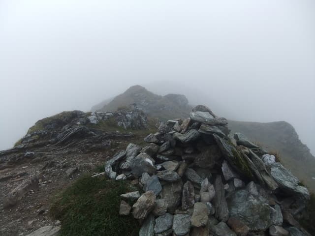
This Meall Garbh — "rough hill", one of several so named — is the 1123m Munro in the Ben Lawers group, the second peak going east from Ben Lawers itself along the great Loch Tay ridge. The summit is a small cairn on a rounded grassy top, with the steeper north face dropping to Lochan nan Cat. Almost always climbed in tandem with An Stuc and the other Lawers Munros as part of a long ridge traverse rather than as a single hill.
Gaelic: “rounded hill, rough” · Pronunciation: myowl garrav
Quick facts
- Height
- 1123.1m/ 3685ft
- Prominence
- 198 m
- Distance
- 18 km
- Ascent
- 988 m
- Time
- 6–9 hrs
- Grid ref
- NN644437
- Parking
- NN608378
- Nearest city
- Perth· 51km
- Dogs
- Dogs on lead required near livestockDog-friendly guide ↗
Height and prominence cross-checked against the Database of British and Irish Hills (CC BY).
No GPX track yet
Walked this route? Share your track to help other walkers.
Standard route
Lawers path 30% · Open hillside 40% · Summit ridge 30%
Most parties tackle the Lawers Group from the NTS visitor centre, traversing south to north over Beinn Ghlas, Ben Lawers, An Stuc, Meall Garbh and Meall Greigh — around 17km with 1700m of cumulative ascent. The 18km/988m figures are for a shorter four-Munro round. The Lawers village approach gives a more direct ascent of Meall Garbh alone via the north ridge from Loch Tay.
Terrain
The NTS Lawers path is well-built gravel through the nature reserve. The ridge between Lawers and Meall Garbh is short grass and rocky outcrops with one short steep section onto An Stuc that needs care. The Meall Garbh summit dome itself is rounded grass with no exposure. The north face drops steeply into Lochan nan Cat — stay clear of the rim in mist.
In winter
A serious winter ridge despite the modest grades — An Stuc has a recognised winter crux that catches walkers out, and cornicing on the north sides of Meall Garbh is consistent. The Lawers visitor centre car park is gritted. SAIS Southern Cairngorms applies. Plan the ridge in good visibility only; navigation between tops in mist is awkward.
Best time of year
Getting there
- Glasgow2h 52m
- Edinburgh2h 58m
OS maps: OS Landranger 51
Mobile signal: Good signal on the lower slopes near Lawers village. The Ben Lawers NTS car park has reliable 4G. Signal becomes patchy above 900m on the northern flanks.
Current conditions
Daylight Today
- Sunrise
- 05:01
- Sunset
- 21:46
- Civil dawn
- 04:07
- Civil dusk
- 22:40
NOAA Solar Calculator · 23 July 2026
Pair with
Curated multi-hill combinations from Meall Garbh.
Around Meall Garbh on the SCOT network
Getting there, basing yourself, and what to do off the hill.
Getting there: Rannoch station
Rannoch Moor — remote West Highland Line stop; Schiehallion approach via bus
27km from the hill
tripscot.co.uk
On TripSCOTBase yourself in Aberfeldy
Loch Tay base — Ben Lawers, Tarmachan ridge, Birks of Aberfeldy
22km from the hill
tripscot.co.uk
On TasteSCOTAfter the hill: Aberfeldy
Aberfeldy — heart of Dewar's blends; honey-and-heather Highland style
22km from the hill
tastescot.co.uk
Meall Garbh — common questions
- What difficulty is Meall Garbh?
- On the OutdoorSCOT scale, Meall Garbh comes in at 3/5 — moderately challenging. Expect roughly 18km and 988m of ascent on the usual route — 6-9 hours for most parties. Ground conditions: The NTS Lawers path is well-built gravel through the nature reserve.
- How much drop does Meall Garbh have?
- The drop is 198m: measured from the summit of Meall Garbh down to the saddle joining it to higher terrain.
- Where's the parking for Meall Garbh?
- Park at NN608378. Double-check the grid reference on an OS map first; informal laybys here fill early in high season.
- What's the best month to climb Meall Garbh?
- Aim for May, June, July, August, September, October on Meall Garbh. In the remaining months treat it as a winter hill — full kit, solid navigation, and a look at the relevant SAIS avalanche forecast before you go.
- Can dogs go up Meall Garbh?
- Dogs are fine on a lead. The route passes livestock or ground-nesting bird habitat, so keep them close throughout.
- Will I get phone signal on Meall Garbh?
- Good signal on the lower slopes near Lawers village. The Ben Lawers NTS car park has reliable 4G. Signal becomes patchy above 900m on the northern flanks.
- Is Meall Garbh safe in winter?
- A serious winter ridge despite the modest grades — An Stuc has a recognised winter crux that catches walkers out, and cornicing on the north sides of Meall Garbh is consistent. The Lawers visitor centre car park is gritted. SAIS Southern Cairngorms applies. Plan the ridge in good visibility only; navigation between tops in mist is awkward.
Get the OutdoorSCOT weekly
One email a week — new route, hill and bothy guides, seasonal conditions and the odd hard-won lesson. No spam, unsubscribe in one click.