Graham · Fife & Perthshire
Meall a' Mhuic
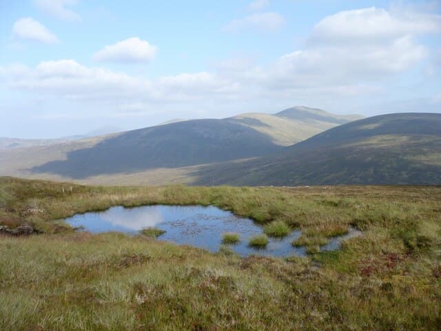
A heather-and-grass moorland Graham above the south side of Loch Rannoch, near the Bridge of Gaur. Its name, the hill of the pig, hints at the rooted-up peaty ground; the position commands a fine cross-loch view of Schiehallion.
Quick facts
- Height
- 745.9m/ 2447ft
- Prominence
- 236 m
- Distance
- 14 km
- Ascent
- 611 m
- Time
- 4–7 hrs
- Grid ref
- NN579508
- Parking
- NN556566
- Nearest
- Fort William· Glasgow 85km
- Dogs
- Dogs on lead required near livestockDog-friendly guide ↗
Height and prominence cross-checked against the Database of British and Irish Hills (CC BY).
No GPX track yet
Walked this route? Share your track to help other walkers.
Standard route
estate track 35% · heather hillside 40% · grassy upper slopes 15% · summit area 10%
Park near the bridge over the Allt Camghouran on the south Loch Rannoch road and walk south on the estate vehicle track. Branch east onto a grassy spur and follow the broad ridge to the highest point.
Terrain
Forestry road in, then a rough track and finally pathless peat and tussock. Wet boots almost certain in any season.
In winter
A low-altitude hill where winter conditions arrive late and depart fast. Frost-hardened bog is a delight to walk on but rapid freeze-thaw makes burn crossings dicey when the loch level rises.
Best time of year
Getting there
- Glasgow2h 49m
- Edinburgh2h 11m
OS maps: OS Landranger 42, OS Landranger 51
Mobile signal: Faint signal in upper Glen Lyon area
Current conditions
Daylight Today
- Sunrise
- 04:51
- Sunset
- 21:56
- Civil dawn
- 03:53
- Civil dusk
- 22:53
NOAA Solar Calculator · 17 July 2026
Pair with
Curated multi-hill combinations from Meall a' Mhuic.
Around Meall a' Mhuic on the SCOT network
Getting there, basing yourself, and what to do off the hill.
Getting there: Rannoch station
Rannoch Moor — remote West Highland Line stop; Schiehallion approach via bus
18km from the hill
tripscot.co.uk
On TripSCOTBase yourself in Aberfeldy
Loch Tay base — Ben Lawers, Tarmachan ridge, Birks of Aberfeldy
28km from the hill
tripscot.co.uk
On TasteSCOTAfter the hill: Aberfeldy
Aberfeldy — heart of Dewar's blends; honey-and-heather Highland style
28km from the hill
tastescot.co.uk
Meall a' Mhuic — common questions
- How difficult is Meall a' Mhuic?
- Meall a' Mhuic carries a 4/5 (challenging) grade on the OutdoorSCOT scale. Count on about 14km, 611m of ascent and a 4-7 hour day on the standard route. Underfoot: Forestry road in, then a rough track and finally pathless peat and tussock.
- What is Meall a' Mhuic's prominence?
- 236m of prominence. That's the vertical drop from the summit to the col that links Meall a' Mhuic to the next higher ground.
- Where do I park for Meall a' Mhuic?
- Most walkers start from NN556566 near Fort William. Verify the grid reference on an OS map before you set off — space is tight on busy summer weekends.
- When is the best time to climb Meall a' Mhuic?
- April, May, June, July, August, September, October give the most reliable conditions on Meall a' Mhuic. Beyond that window the high ground turns wintry: carry full mountain kit, be confident navigating, and check the SAIS avalanche forecast for the area.
- Is Meall a' Mhuic dog-friendly?
- Yes, but dogs must be kept on a lead — there is livestock or ground-nesting bird interest on the route.
- Is there mobile signal on Meall a' Mhuic?
- Faint signal in upper Glen Lyon area
- Is Meall a' Mhuic safe in winter?
- A low-altitude hill where winter conditions arrive late and depart fast. Frost-hardened bog is a delight to walk on but rapid freeze-thaw makes burn crossings dicey when the loch level rises.
Get the OutdoorSCOT weekly
One email a week — new route, hill and bothy guides, seasonal conditions and the odd hard-won lesson. No spam, unsubscribe in one click.