Graham · Fife & Perthshire
Creag Gharbh
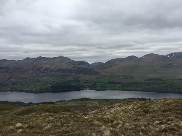
Creag Gharbh (637m) — the rough crag — is a south-side Loch Tay hill in the NN63 square between Killin and Ardeonaig. A rocky knoll marks the high point of a heathery ridge with views across Loch Tay to Ben Lawers and east along the loch toward Kenmore.
Gaelic: “crag, rough” · Pronunciation: krayg yarrav
Quick facts
- Height
- 637.4m/ 2091ft
- Prominence
- 151 m
- Distance
- 12 km
- Ascent
- 478 m
- Time
- 3–5 hrs
- Grid ref
- NN632327
- Parking
- NN663355
- Nearest city
- Stirling· 43km
- Dogs
- Dogs on lead required near livestockDog-friendly guide ↗
Height and prominence cross-checked against the Database of British and Irish Hills (CC BY).
No GPX track yet
Walked this route? Share your track to help other walkers.
Standard route
heather moorland 50% · rocky hillside 35% · grass and sedge 15%
Park at Ardeonaig village hall on the south Loch Tay road. Take the minor road south past the cottages, then follow the estate track climbing west into Glen Lochay. Leave the track on a quad rut north-west onto the ridge crest and follow it pathlessly to the rocky knoll at the summit.
Terrain
Public road and estate track for two thirds of the climb, then trackless heather and outcrop on the crest. The summit knoll is small but unmistakable on the gently rolling ridge — false tops are infrequent.
In winter
South Loch Tay catches eastern continental cold spells and Creag Gharbh holds snow longer than its height suggests. The summit knoll is exposed to easterly wind that can be biting; the estate track stays walkable for descent. A short half-day fits between dawn and dusk in January.
Best time of year
Getting there
- Glasgow2h 36m
- Edinburgh2h 49m
OS maps: OS Landranger 51
Mobile signal: Moderate. EE intermittent along the south Loch Tay road; weaker on the ridge crest.
Current conditions
Daylight Today
- Sunrise
- 04:45
- Sunset
- 22:00
- Civil dawn
- 03:47
- Civil dusk
- 22:59
NOAA Solar Calculator · 13 July 2026
Around Creag Gharbh on the SCOT network
Getting there, basing yourself, and what to do off the hill.
Getting there: Crianlarich station
Crianlarich Munros — Ben More, Stob Binnein, Ben Lui, Cruach Ardrain
26km from the hill
tripscot.co.uk
On TripSCOTBase yourself in Callander
Trossachs gateway — Ben Ledi, Stuc a Chroin, Rob Roy Way
24km from the hill
tripscot.co.uk
On TasteSCOTAfter the hill: The Glenturret
Crieff — Scotland's oldest working distillery; Famous Grouse Experience
23km from the hill
tastescot.co.uk
Creag Gharbh — common questions
- How hard is Creag Gharbh?
- We grade Creag Gharbh at 3/5, which puts it in moderately challenging territory. The usual route is around 12km with 478m of climbing; allow 3-5 hours. Underfoot: Public road and estate track for two thirds of the climb, then trackless heather and outcrop on the crest.
- What is Creag Gharbh's prominence?
- 151m of prominence. That's the vertical drop from the summit to the col that links Creag Gharbh to the next higher ground.
- Where do I park for Creag Gharbh?
- Most walkers start from NN663355. Verify the grid reference on an OS map before you set off — space is tight on busy summer weekends.
- When is the best time to climb Creag Gharbh?
- March, April, May, June, July, August, September, October, November give the most reliable conditions on Creag Gharbh. Beyond that window the high ground turns wintry: carry full mountain kit, be confident navigating, and check the SAIS avalanche forecast for the area.
- Is Creag Gharbh dog-friendly?
- Yes, but dogs must be kept on a lead — there is livestock or ground-nesting bird interest on the route.
- Is there mobile signal on Creag Gharbh?
- Moderate. EE intermittent along the south Loch Tay road; weaker on the ridge crest.
- Is Creag Gharbh safe in winter?
- South Loch Tay catches eastern continental cold spells and Creag Gharbh holds snow longer than its height suggests. The summit knoll is exposed to easterly wind that can be biting; the estate track stays walkable for descent. A short half-day fits between dawn and dusk in January.
Get the OutdoorSCOT weekly
One email a week — new route, hill and bothy guides, seasonal conditions and the odd hard-won lesson. No spam, unsubscribe in one click.