Graham · Fife & Perthshire
Creag Ruadh
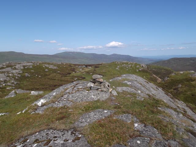
Creag Ruadh (712m) — the red crag — sits at NN67 on the south side of Glen Lyon near Fortingall, the village famous for its ancient yew. A reddish schist scarp gives the hill its name; the small cairn on top looks down the longest glen in Scotland and across to the Ben Lawers Munros. The hill hides behind the more obvious Stuc an Lochain — much of its appeal lies in that quiet shoulder away from popular routes.
Gaelic: “crag, red” · Pronunciation: krayg roo-ah
Quick facts
- Height
- 712.3m/ 2337ft
- Prominence
- 199 m
- Distance
- 13 km
- Ascent
- 584 m
- Time
- 3–6 hrs
- Grid ref
- NN673292
- Nearest city
- Stirling· 38km
- Dogs
- Dogs on lead required near livestockDog-friendly guide ↗
Height and prominence cross-checked against the Database of British and Irish Hills (CC BY).
No GPX track yet
Walked this route? Share your track to help other walkers.
Standard route
estate track 30% · heather hillside 40% · grassy ridge 20% · summit area 10%
Start from the Glen Lyon road parking near Bridge of Balgie or further east along the public road. A hydro-board track climbs steeply north into Coire a' Mhuic, then the route swings west onto the heathery shoulder. 13km return for a circuit, 584m climbed. Best done as an out-and-back on the same ridge unless the river crossings in the corrie are passable.
Terrain
Hydro tracks and quad lines reach surprisingly high before giving way to mat-grass and reddish schist scree. Watch for fence wire across the upper ridge — much of it is collapsed and easy to trip on. The summit cairn is on a small grassy platform above a steep northeast face.
In winter
Glen Lyon's east-facing scarps hold drift snow well into April. The southern Cairngorms SAIS area covers the nearest equivalents; locally, the steep northeast face above Coire a' Mhuic accumulates windslab in westerly storms. Daylight is decent for this latitude — around eight hours in midwinter — but the deep glen casts long shadow by mid-afternoon.
Best time of year
Getting there
- Glasgow2h 32m
- Edinburgh2h 42m
OS maps: OS Landranger 51, OS Explorer 365
Mobile signal: Patchy in Glen Lyon — occasional signal on the upper shoulder toward Loch Tay
Current conditions
Daylight Today
- Sunrise
- 04:45
- Sunset
- 21:59
- Civil dawn
- 03:47
- Civil dusk
- 22:58
NOAA Solar Calculator · 13 July 2026
Around Creag Ruadh on the SCOT network
Getting there, basing yourself, and what to do off the hill.
Getting there: Crianlarich station
Crianlarich Munros — Ben More, Stob Binnein, Ben Lui, Cruach Ardrain
29km from the hill
tripscot.co.uk
On TripSCOTBase yourself in Callander
Trossachs gateway — Ben Ledi, Stuc a Chroin, Rob Roy Way
21km from the hill
tripscot.co.uk
On TasteSCOTAfter the hill: The Glenturret
Crieff — Scotland's oldest working distillery; Famous Grouse Experience
18km from the hill
tastescot.co.uk
Creag Ruadh — common questions
- How hard is Creag Ruadh?
- We grade Creag Ruadh at 3/5, which puts it in moderately challenging territory. The usual route is around 13km with 584m of climbing; allow 3-6 hours. Ground conditions: Hydro tracks and quad lines reach surprisingly high before giving way to mat-grass and reddish schist scree.
- How much drop does Creag Ruadh have?
- The drop is 199m: measured from the summit of Creag Ruadh down to the saddle joining it to higher terrain.
- What's the best month to climb Creag Ruadh?
- Aim for April, May, June, July, August, September, October on Creag Ruadh. In the remaining months treat it as a winter hill — full kit, solid navigation, and a look at the relevant SAIS avalanche forecast before you go.
- Can dogs go up Creag Ruadh?
- Dogs are fine on a lead. The route passes livestock or ground-nesting bird habitat, so keep them close throughout.
- Will I get phone signal on Creag Ruadh?
- Patchy in Glen Lyon — occasional signal on the upper shoulder toward Loch Tay
- Is Creag Ruadh safe in winter?
- Glen Lyon's east-facing scarps hold drift snow well into April. The southern Cairngorms SAIS area covers the nearest equivalents; locally, the steep northeast face above Coire a' Mhuic accumulates windslab in westerly storms. Daylight is decent for this latitude — around eight hours in midwinter — but the deep glen casts long shadow by mid-afternoon.
Get the OutdoorSCOT weekly
One email a week — new route, hill and bothy guides, seasonal conditions and the odd hard-won lesson. No spam, unsubscribe in one click.