Corbett · Fife & Perthshire
Creag Uchdag
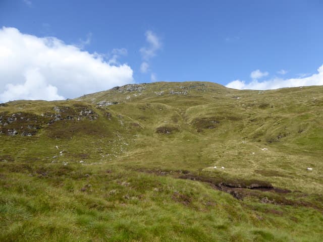
Creag Uchdag — 'the crag of the brow' — is the 878m Corbett standing north of Loch Earn at the head of Glen Lednock, between Comrie and Loch Tay. The mountain has steep crags on its north-west face dropping into the upper Lednock glen, giving its name; the south side is gentler and provides the walking line of ascent. The summit gives a panoramic view down Loch Earn and across to Ben Vorlich and Stuc a' Chroin, with the Lawers range stretching north.
Quick facts
- Height
- 878.8m/ 2883ft
- Prominence
- 276 m
- Distance
- 13 km
- Ascent
- 700 m
- Time
- 3–5 hrs
- Grid ref
- NN708323
- Parking
- NN744275
- Nearest city
- Stirling· 40km
- Dogs
- Dogs on lead required near livestockDog-friendly guide ↗
Height and prominence cross-checked against the Database of British and Irish Hills (CC BY).
No GPX track yet
Walked this route? Share your track to help other walkers.
Standard route
glen track 20% · stalkers path 40% · heather moorland 30% · summit area 10%
From Comrie, drive up Glen Lednock to the parking near Invergeldie Farm (NN744275). Walk north on the estate track up Glen Lednock for around 4km, then strike off the track and climb onto Creag Uchdag's broad south-east shoulder. A steady pull leads to the summit trig point. Allow 5–6 hours.
Terrain
An estate Land Rover track covers the lower approach. Once on the open hill, the going turns to heather and grass on a broad ridge with no rocky difficulties on the standard line. The north-west face is the day's exception — steep crags dropping into the upper Lednock that gave the hill its name. Keep clear of the rim in cloud.
In winter
An accessible winter Corbett — Glen Lednock holds snow well from January through March. The estate track ices up but stays driveable. Cornices form on the north-west rim above the crags; pre-plan the descent line to avoid them. Cold continental easterlies funneling down Loch Earn can be brutal.
Best time of year
Getting there
- Glasgow2h 37m
- Edinburgh2h 42m
OS maps: OS Landranger 51, OS Landranger 52
Mobile signal: Poor signal in Glen Lednock; brief coverage near Comrie
Current conditions
Daylight Today
- Sunrise
- 04:51
- Sunset
- 21:54
- Civil dawn
- 03:54
- Civil dusk
- 22:51
NOAA Solar Calculator · 17 July 2026
Around Creag Uchdag on the SCOT network
Getting there, basing yourself, and what to do off the hill.
Getting there: Gleneagles station
Glen Devon; Ochil ridges; Auchterarder; PGA Centenary course access
29km from the hill
tripscot.co.uk
On TripSCOTBase yourself in Aberfeldy
Loch Tay base — Ben Lawers, Tarmachan ridge, Birks of Aberfeldy
22km from the hill
tripscot.co.uk
On TasteSCOTAfter the hill: The Glenturret
Crieff — Scotland's oldest working distillery; Famous Grouse Experience
16km from the hill
tastescot.co.uk
Creag Uchdag — common questions
- How hard is Creag Uchdag?
- We grade Creag Uchdag at 2/5, which puts it in moderate territory. The usual route is around 13km with 700m of climbing; allow 3-5 hours. Underfoot: An estate Land Rover track covers the lower approach.
- What is Creag Uchdag's prominence?
- 276m of prominence. That's the vertical drop from the summit to the col that links Creag Uchdag to the next higher ground.
- Where do I park for Creag Uchdag?
- Most walkers start from NN744275. Verify the grid reference on an OS map before you set off — space is tight on busy summer weekends.
- When is the best time to climb Creag Uchdag?
- May, June, July, August, September, October give the most reliable conditions on Creag Uchdag. Beyond that window the high ground turns wintry: carry full mountain kit, be confident navigating, and check the SAIS avalanche forecast for the area.
- Is Creag Uchdag dog-friendly?
- Yes, but dogs must be kept on a lead — there is livestock or ground-nesting bird interest on the route.
- Is there mobile signal on Creag Uchdag?
- Poor signal in Glen Lednock; brief coverage near Comrie
- Is Creag Uchdag safe in winter?
- An accessible winter Corbett — Glen Lednock holds snow well from January through March. The estate track ices up but stays driveable. Cornices form on the north-west rim above the crags; pre-plan the descent line to avoid them. Cold continental easterlies funneling down Loch Earn can be brutal.
Get the OutdoorSCOT weekly
One email a week — new route, hill and bothy guides, seasonal conditions and the odd hard-won lesson. No spam, unsubscribe in one click.