Corbett · Fife & Perthshire
Creagan na Beinne
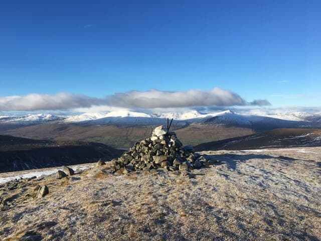
Creagan na Beinne is a quiet grassy Corbett in the rolling country between Loch Tay and the headwaters of the River Almond, south of Aberfeldy. With 460m of prominence it stands clearly apart from its neighbours, though most maps miss it among the busier Lawers and Glen Lyon hills to the north. The 889m summit is a broad flattened dome with one significant crag dropping east — the rocky face that gives the hill its name. Views stretch south to the Ochils and Stirling carse.
Quick facts
- Height
- 889.1m/ 2917ft
- Prominence
- 461 m
- Distance
- 16 km
- Ascent
- 782 m
- Time
- 5–8 hrs
- Grid ref
- NN744368
- Parking
- NN701395
- Nearest city
- Perth· 40km
- Dogs
- Dogs on lead required near livestockDog-friendly guide ↗
Height and prominence cross-checked against the Database of British and Irish Hills (CC BY).
No GPX track yet
Walked this route? Share your track to help other walkers.
Standard route
hill track 35% · open grass 30% · broad ridge 25% · summit dome 10%
Park at Ardtalnaig on the south Loch Tay road and follow the public hill track south up Gleann a Chilleine. After around 4km, branch off the track and head up easy grass to gain the broad south ridge of Creagan na Beinne, then follow it gently north to the summit. Around 16km return with 782m of ascent. The hill pairs naturally with the adjacent Corbett Creag Uchdag across the bealach to the west — most parties do both in a single day from the same start.
Terrain
The Gleann a Chilleine track is firm and well drained, frequently used by stalkers and quad bikes. Beyond the track the surface is short heather and grass with damp patches near the small burns. The summit dome itself is featureless and the small east-facing crag is easily missed in poor light — keep west of the marked top in mist. No technical ground anywhere on the hill.
In winter
A relatively benign winter Corbett — gentle slopes, no avalanche concerns of consequence, and a reliable approach track. Snow cover can be patchy in the south Loch Tay area compared to the Lawers range across the loch. The chief winter difficulties are wind exposure on the bare top and finding the descent line in whiteout. The south Loch Tay road is single-track and refreezes overnight.
Best time of year
Getting there
- Glasgow2h 44m
- Edinburgh2h 44m
OS maps: OS Landranger 51, OS Landranger 52
Mobile signal: Poor signal in Glen Lyon; very brief coverage on high ground with southern views
Current conditions
Daylight Today
- Sunrise
- 04:44
- Sunset
- 21:59
- Civil dawn
- 03:45
- Civil dusk
- 22:58
NOAA Solar Calculator · 13 July 2026
On a long-distance route
Creagan na Beinne sits within 5km of these named long-distance walks — useful for trail-pack rest days or section extensions.
Around Creagan na Beinne on the SCOT network
Getting there, basing yourself, and what to do off the hill.
Getting there: Dunkeld & Birnam station
Birnam Hill, Hermitage walks, southern Perthshire gateway
29km from the hill
tripscot.co.uk
On TripSCOTBase yourself in Aberfeldy
Loch Tay base — Ben Lawers, Tarmachan ridge, Birks of Aberfeldy
17km from the hill
tripscot.co.uk
On TasteSCOTAfter the hill: Aberfeldy
Aberfeldy — heart of Dewar's blends; honey-and-heather Highland style
17km from the hill
tastescot.co.uk
Creagan na Beinne — common questions
- How hard is Creagan na Beinne?
- We grade Creagan na Beinne at 3/5, which puts it in moderately challenging territory. The usual route is around 16km with 782m of climbing; allow 5-8 hours. Terrain: The Gleann a Chilleine track is firm and well drained, frequently used by stalkers and quad bikes.
- How prominent is Creagan na Beinne?
- Creagan na Beinne has 461m of topographic prominence — the height of its summit above the highest col connecting it to higher ground.
- Where should I park to climb Creagan na Beinne?
- Standard parking is at NN701395. Check the parking grid reference on an OS map before travel; informal laybys can fill on summer weekends.
- When should I climb Creagan na Beinne?
- The standard good-weather months for Creagan na Beinne are May, June, July, August, September, October. Outside those months, expect winter conditions on the high ground — full mountain kit, navigation skills, and a check of the SAIS avalanche forecast for the relevant region.
- Can I bring my dog up Creagan na Beinne?
- On a lead only — the route crosses ground with livestock or nesting-bird interest.
- What's mobile reception like on Creagan na Beinne?
- Poor signal in Glen Lyon; very brief coverage on high ground with southern views
- Is Creagan na Beinne safe in winter?
- A relatively benign winter Corbett — gentle slopes, no avalanche concerns of consequence, and a reliable approach track. Snow cover can be patchy in the south Loch Tay area compared to the Lawers range across the loch. The chief winter difficulties are wind exposure on the bare top and finding the descent line in whiteout. The south Loch Tay road is single-track and refreezes overnight.
Get the OutdoorSCOT weekly
One email a week — new route, hill and bothy guides, seasonal conditions and the odd hard-won lesson. No spam, unsubscribe in one click.