Graham · Fife & Perthshire
Beinn na Gainimh
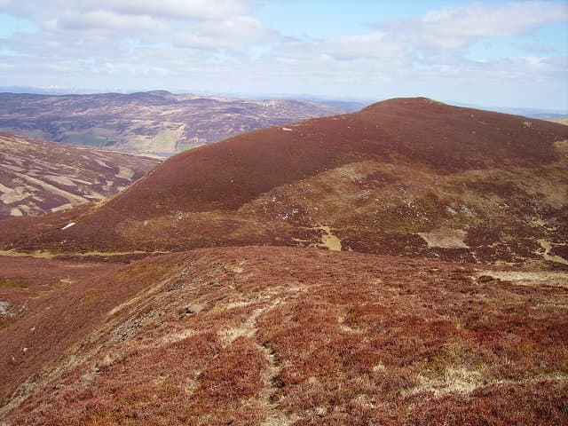
A rolling Perthshire Graham on the watershed between Glen Almond and Glen Quaich. Open sheep grazing country — easy walking in clear weather, demanding to navigate in cloud. The 729 m top sits in the fife perthshire; reckon on 13 km and 598 m of ascent for the round trip.
Quick facts
- Height
- 729.3m/ 2393ft
- Prominence
- 287 m
- Distance
- 13 km
- Ascent
- 598 m
- Time
- 3–6 hrs
- Grid ref
- NN837344
- Parking
- NN828349
- Nearest city
- Perth· 30km
- Dogs
- Dogs on lead required near livestockDog-friendly guide ↗
Height and prominence cross-checked against the Database of British and Irish Hills (CC BY).
No GPX track yet
Walked this route? Share your track to help other walkers.
Standard route
moorland path 20% · bog and heather 50% · grassy upper slopes 20% · summit area 10%
Park at the Newton Bridge car park in the Sma' Glen. Follow the General Wade military road north up Glen Almond, then break left on the estate track toward Auchnafree and climb the south-east shoulder. Wide grassy slopes lead to the trig.
Terrain
Wade road and estate tracks for two-thirds of the route. The upper hill is short-cropped sheep grass with occasional peat hags. Easy walking but featureless.
In winter
Eastern Highlands snow patterns — cold, dry powder rather than wet maritime snow. The plateau in cloud is genuinely disorienting; navigation is the main difficulty rather than steep ground.
Best time of year
Getting there
- Glasgow2h 45m
- Edinburgh2h 45m
OS maps: OS Landranger 52
Mobile signal: Reception at Newton Bridge; intermittent in upper Glen Almond
Current conditions
Daylight Today
- Sunrise
- 04:44
- Sunset
- 21:59
- Civil dawn
- 03:45
- Civil dusk
- 22:58
NOAA Solar Calculator · 13 July 2026
Around Beinn na Gainimh on the SCOT network
Getting there, basing yourself, and what to do off the hill.
Getting there: Dunkeld & Birnam station
Birnam Hill, Hermitage walks, southern Perthshire gateway
21km from the hill
tripscot.co.uk
On TripSCOTBase yourself in Aberfeldy
Loch Tay base — Ben Lawers, Tarmachan ridge, Birks of Aberfeldy
15km from the hill
tripscot.co.uk
On TasteSCOTAfter the hill: The Glenturret
Crieff — Scotland's oldest working distillery; Famous Grouse Experience
11km from the hill
tastescot.co.uk
Beinn na Gainimh — common questions
- What difficulty is Beinn na Gainimh?
- On the OutdoorSCOT scale, Beinn na Gainimh comes in at 3/5 — moderately challenging. Expect roughly 13km and 598m of ascent on the usual route — 3-6 hours for most parties. Underfoot: Wade road and estate tracks for two-thirds of the route.
- What is Beinn na Gainimh's prominence?
- 287m of prominence. That's the vertical drop from the summit to the col that links Beinn na Gainimh to the next higher ground.
- Where do I park for Beinn na Gainimh?
- Most walkers start from NN828349. Verify the grid reference on an OS map before you set off — space is tight on busy summer weekends.
- When is the best time to climb Beinn na Gainimh?
- April, May, June, July, August, September, October give the most reliable conditions on Beinn na Gainimh. Beyond that window the high ground turns wintry: carry full mountain kit, be confident navigating, and check the SAIS avalanche forecast for the area.
- Is Beinn na Gainimh dog-friendly?
- Yes, but dogs must be kept on a lead — there is livestock or ground-nesting bird interest on the route.
- Is there mobile signal on Beinn na Gainimh?
- Reception at Newton Bridge; intermittent in upper Glen Almond
- Is Beinn na Gainimh safe in winter?
- Eastern Highlands snow patterns — cold, dry powder rather than wet maritime snow. The plateau in cloud is genuinely disorienting; navigation is the main difficulty rather than steep ground.
Get the OutdoorSCOT weekly
One email a week — new route, hill and bothy guides, seasonal conditions and the odd hard-won lesson. No spam, unsubscribe in one click.