Graham · Fife & Perthshire
Meall Reamhar
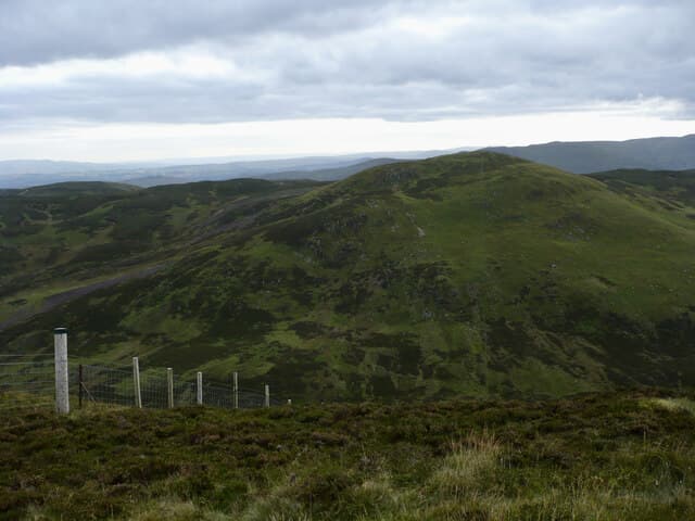
Meall Reamhar (617m), the broad lump, sits beside Meall nan Caorach above Glen Quaich in the NN93 square, the pair forming a natural Perthshire double. The summit cairn crowns a wide grass plateau looking south over the Sma' Glen and the Tay valley. A second hill of the same name lies up by Glen Tilt — this is the southern one and is much the more accessible of the pair.
Quick facts
- Height
- 617.8m/ 2027ft
- Prominence
- 154 m
- Distance
- 12 km
- Ascent
- 463 m
- Time
- 3–5 hrs
- Grid ref
- NN922332
- Parking
- NN925335
- Nearest city
- Perth· 22km
- Dogs
- Dogs on lead required near livestockDog-friendly guide ↗
Height and prominence cross-checked against the Database of British and Irish Hills (CC BY).
No GPX track yet
Walked this route? Share your track to help other walkers.
Standard route
heather moorland 65% · grass slopes 25% · rocky summit 10%
Park at NN925335 on the Glen Quaich road and pick up the estate track climbing west onto the broad ridge between the two Grahams. The ground is firm grass and short heather. From the col swing south-east onto Meall Reamhar in about twenty minutes. The combined round of both Grahams takes around five hours; on its own this hill is closer to three.
Terrain
Firm grass cropped by sheep and red deer makes for easy walking once on the ridge. The track is the cleanest way onto the plateau; off it the heather is short and well-managed. The west flank steepens above a small reservoir — keep east of it on the descent.
In winter
Glen Quaich often holds a cold inversion and Meall Reamhar's open plateau ices up readily when the freezing level falls. The estate track gives the safest descent line in poor weather. With the road over the glen high and exposed, check the Aberfeldy weather before setting out.
Best time of year
Getting there
- Glasgow2h 48m
- Edinburgh2h 37m
OS maps: OS Landranger 52
Mobile signal: Variable. EE intermittent on the plateau; better on south-facing slopes.
Current conditions
Daylight Today
- Sunrise
- 04:43
- Sunset
- 21:58
- Civil dawn
- 03:45
- Civil dusk
- 22:57
NOAA Solar Calculator · 13 July 2026
Around Meall Reamhar on the SCOT network
Getting there, basing yourself, and what to do off the hill.
Getting there: Dunkeld & Birnam station
Birnam Hill, Hermitage walks, southern Perthshire gateway
14km from the hill
tripscot.co.uk
On TripSCOTBase yourself in Dunkeld
Southern Cairngorms gateway — Hermitage, Loch of the Lowes
14km from the hill
tripscot.co.uk
On TasteSCOTAfter the hill: The Glenturret
Crieff — Scotland's oldest working distillery; Famous Grouse Experience
13km from the hill
tastescot.co.uk
Meall Reamhar — common questions
- What difficulty is Meall Reamhar?
- On the OutdoorSCOT scale, Meall Reamhar comes in at 3/5 — moderately challenging. Expect roughly 12km and 463m of ascent on the usual route — 3-5 hours for most parties. Terrain: Firm grass cropped by sheep and red deer makes for easy walking once on the ridge.
- How prominent is Meall Reamhar?
- Meall Reamhar has 154m of topographic prominence — the height of its summit above the highest col connecting it to higher ground.
- Where should I park to climb Meall Reamhar?
- Standard parking is at NN925335. Check the parking grid reference on an OS map before travel; informal laybys can fill on summer weekends.
- When should I climb Meall Reamhar?
- The standard good-weather months for Meall Reamhar are March, April, May, June, July, August, September, October, November. Outside those months, expect winter conditions on the high ground — full mountain kit, navigation skills, and a check of the SAIS avalanche forecast for the relevant region.
- Can I bring my dog up Meall Reamhar?
- On a lead only — the route crosses ground with livestock or nesting-bird interest.
- What's mobile reception like on Meall Reamhar?
- Variable. EE intermittent on the plateau; better on south-facing slopes.
- Is Meall Reamhar safe in winter?
- Glen Quaich often holds a cold inversion and Meall Reamhar's open plateau ices up readily when the freezing level falls. The estate track gives the safest descent line in poor weather. With the road over the glen high and exposed, check the Aberfeldy weather before setting out.
Get the OutdoorSCOT weekly
One email a week — new route, hill and bothy guides, seasonal conditions and the odd hard-won lesson. No spam, unsubscribe in one click.