Graham · Fife & Perthshire
Meall nan Caorach
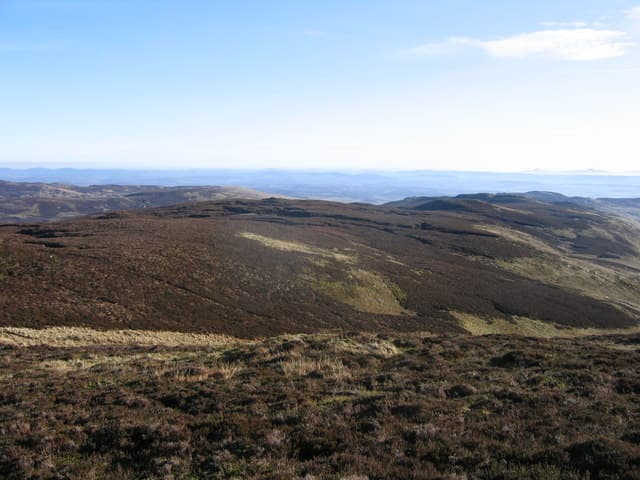
Meall nan Caorach (623m), the hill of the sheep, rises north of the Sma' Glen in the NN93 square, between Glen Almond and Glen Quaich. The collapsed shelter cairn at the top sits on a broad grass plateau with a view that takes in Ben Chonzie, Schiehallion and the Lowther line of the Ochils away to the south-east. The hill is regularly paired with neighbouring Meall Reamhar for a short Perthshire round.
Quick facts
- Height
- 623.7m/ 2046ft
- Prominence
- 322 m
- Distance
- 12 km
- Ascent
- 467 m
- Time
- 3–5 hrs
- Grid ref
- NN928338
- Parking
- NN895332
- Nearest city
- Perth· 21km
- Dogs
- Dogs on lead required near livestockDog-friendly guide ↗
Height and prominence cross-checked against the Database of British and Irish Hills (CC BY).
No GPX track yet
Walked this route? Share your track to help other walkers.
Standard route
heather moorland 65% · grass slopes 25% · rocky summit 10%
From the verge parking at NN895332 on the Glen Quaich road, take the stalkers' path up Glen Lochan before climbing onto the south-west shoulder. Grass and short heather dominate the upper hill. Continue across the broad summit to the shelter — there is no separate cairn, just a low collar of stones. Allow about three and a half hours to the top and back; pairing with Meall Reamhar adds an hour.
Terrain
Short cropped grass and heather give fast walking on the lower hill, with a stalkers' path of variable quality up Glen Lochan. The plateau is firm underfoot but featureless — visiting the shelter cairn in cloud needs a bearing. Burns flowing south toward the Sma' Glen can swell after rain.
In winter
Eastern Perthshire winters bring crisp, settled spells punctuated by easterly snowfall that drifts on the broad plateau. The hill is gentle but the shelter cairn is the only landmark in deep snow, making compass work important. Glen Quaich road is high and can be impassable in winter, so check before setting out.
Best time of year
Getting there
- Glasgow2h 49m
- Edinburgh2h 38m
OS maps: OS Landranger 52
Mobile signal: Variable. EE patchy on the summit; better on south-facing slopes toward Crieff.
Current conditions
Daylight Today
- Sunrise
- 04:43
- Sunset
- 21:58
- Civil dawn
- 03:45
- Civil dusk
- 22:57
NOAA Solar Calculator · 13 July 2026
Around Meall nan Caorach on the SCOT network
Getting there, basing yourself, and what to do off the hill.
Getting there: Dunkeld & Birnam station
Birnam Hill, Hermitage walks, southern Perthshire gateway
13km from the hill
tripscot.co.uk
On TripSCOTBase yourself in Dunkeld
Southern Cairngorms gateway — Hermitage, Loch of the Lowes
13km from the hill
tripscot.co.uk
On TasteSCOTAfter the hill: The Glenturret
Crieff — Scotland's oldest working distillery; Famous Grouse Experience
14km from the hill
tastescot.co.uk
Meall nan Caorach — common questions
- How hard is Meall nan Caorach?
- We grade Meall nan Caorach at 3/5, which puts it in moderately challenging territory. The usual route is around 12km with 467m of climbing; allow 3-5 hours. Underfoot: Short cropped grass and heather give fast walking on the lower hill, with a stalkers' path of variable quality up Glen Lochan.
- What is Meall nan Caorach's prominence?
- 322m of prominence. That's the vertical drop from the summit to the col that links Meall nan Caorach to the next higher ground.
- Where do I park for Meall nan Caorach?
- Most walkers start from NN895332. Verify the grid reference on an OS map before you set off — space is tight on busy summer weekends.
- When is the best time to climb Meall nan Caorach?
- March, April, May, June, July, August, September, October, November give the most reliable conditions on Meall nan Caorach. Beyond that window the high ground turns wintry: carry full mountain kit, be confident navigating, and check the SAIS avalanche forecast for the area.
- Is Meall nan Caorach dog-friendly?
- Yes, but dogs must be kept on a lead — there is livestock or ground-nesting bird interest on the route.
- Is there mobile signal on Meall nan Caorach?
- Variable. EE patchy on the summit; better on south-facing slopes toward Crieff.
- Is Meall nan Caorach safe in winter?
- Eastern Perthshire winters bring crisp, settled spells punctuated by easterly snowfall that drifts on the broad plateau. The hill is gentle but the shelter cairn is the only landmark in deep snow, making compass work important. Glen Quaich road is high and can be impassable in winter, so check before setting out.
Get the OutdoorSCOT weekly
One email a week — new route, hill and bothy guides, seasonal conditions and the odd hard-won lesson. No spam, unsubscribe in one click.